Address

Abisko Scientific Research Station
Vetenskapens Väg 38
SE 981 07 Abisko
Sweden

Station manager

Margareta Johansosn
E-mail: margareta.johansson@polar.se

Contact Station

Phone: +46 (0) 980400 21
E-mail: ans@polar.se

www.polar.se/abisko

Station Features

Opening year: 1913 Status: Open
  • Type of station: Station
  • Operational period – year-round or Month A to Month B: Year-round
  • Name of station owner: Swedish Polar Research Secretariat
  • Type of owner: Government
  • Name of managing institution: Swedish Polar Research Secretariat
  • Managing Institution Country: Sweden
  • Station owner country: Sweden
  • Partner institution: No
  • Station latitude: 68,35440556
  • Station longitude: 18,81590833
  • Country (station location): Sweden
  • Altitude of station: 380 m a.s.l
  • Min. altitude within study area: 345 m a.s.l
  • Max. altitude within study area: 1800 m a.s.l
  • Nearest town/settlement: Abisko (~150 inhabitants)
  • Distance to nearest town/settlement: 1 km
  • Number of residents in nearest town: 150
  • Distance to nearest public transport facility (Airport, Ferry terminal, Train station, Bus station): 1 km
  • Distance to nearest research station: 1 km
  • Maps available at station: Vegetation maps (1:100 000), Geomorphological maps (1:250 000), Mountain maps (1:50 000)
  • Type of surface facility is built on: Rock
  • Climate zone: Sub-Arctic
  • Period of measurments for climate data below [year to year]: 1913-2021
  • Mean annual temperature: -0,4 °C
  • Mean temperature in February: -11 °C
  • Mean temperature in July: 11 °C
  • Min. Temp. (absolute) - date: Thursday, 01 March 2001
  • Min. Temp. (absolute): -39 °C
  • Max. Temp. (absolute): 32,8 °C
  • Precipitation type: Snow, Rain
  • Snow free period (month to month): June to August/September
  • Sea ice break up: January
  • Lake ice break up: June, July
  • River ice break up: June
  • Dominant wind direction: West
  • Mean annual wind speed: 3,9 m/s
  • Maximum wind speed (absolute): 51,5 m/s
  • Landscape features Mountains, Plateaus, Moraines, Valleys, Lake, River, Beach, Rocky shores
  • Permafrost zone Sporadic, Palsa mires
  • Snow and ice on land Glaciers, Permanent snow patches
  • Vegetation zone Tree line, Shrub tundra, Gramminoid tundra, Forest tundra, Peatlands, Wetlands, Peatlands/mires, Deciduous forest, Evergreen forest, Alpine heath, Heath
  • Wildlife Terrestrial carnivores, Ungulates, Hares, Rodents, Bird colonies, Fish
  • Human use Settlement, Fishing, Hunting, Tourism, Animal husbandry, Leisure activities

Facilities

  • Area under roof: 5000 m²
  • Max. number of visitors at a time : 80
  • Showers: Yes
  • Laundry facilities: Yes
  • Power supply – period (from ‘hour’ to ‘hour’ or 24 hours): 24 h
  • Power supply - plug type C, F
  • Power sources at station Municipal grid, Solar, Water, Geothermal
  • Logistics area: 500 m²
  • Conference room capacity: 30
  • Workshops Electrical and IT technologies, Metal, Plexiglas, Wood
  • Means of transportation to/from station Car, Bus, Train, Scheduled flight
  • Air transport landing facilities at station Helipad
  • Airstrip (Length × Width) :
  • Transport on land - at station Snowmobile, Car, Ski, Snow shoes
  • Transport on water - at station Closed boat
  • Water landing facilities Warf/pier, Beach
  • Number of staff peak season/summer: 12
  • Number of staff off season/winter: 12
  • Staff able to assist (fieldwork): Yes - if time allows
  • Staff able to assist (workshops): Yes - if time allows
  • Laboratory area: 600 m²
  • Laboratory equipment Freezer < -80, Freezer -40 - -10, Fridge, Microscopes, Basic laboratory equipment, Basic chemical reagents, Analytical instrumentation
  • Field to station Mobile phone
  • Station to outside world Mobile phone, Internet
  • IT Infrastructure Wifi, Printer
  • Staff with medical training/doctor No
  • Distance to hospital (estimated time – hours): 1
  • Recommended safety equipment Satellite phone, Mobile phone, GPS, First aid kit, Glacier rescue kit, Avalanche rescue kit, Overnight equipment
  • Safety equipment available at station First aid kit, Satellite phone
  • Field power supply available at station: No
  • Field instruments available at station: Please contact us for details

Science

  • Transnational Access: Yes
  • Remote Access: Yes
  • INTERACT Virtual Access: Yes
  • Permitting issues categories
    • Permits required for access to the station
    • Permits required for studies
  • Partner institutions (involved in the operation of the station)
    • Partner institution
  • Climate
    • Snow
    • Rain
    • Hail
  • Housing and accomodation
    • Showers
    • Laundry facilities
    • A
    • B
    • C
    • D
    • E
    • F
    • G
    • H
    • I
    • J
    • K
    • L
    • M
    • N
    • Municipal grid
    • O
    • Diesel/oil/gas
    • Wood
    • Solar
    • Wind
    • Water
    • Geothermal
    • Biofuel
    • Other
  • Logistics
    • Electrical and IT technologies
    • Mechanical
    • Metal
    • Wood
    • Plexiglas
    • Other
    • Walk
    • None
    • Tracked vehicle
    • Truck
    • SUV (4x4)
    • Car
    • Zodiac
    • ATV
    • Snowmobile
    • Open boat/Dhinghy
    • Closed boat
    • Bicycles
    • Ski
    • Amphibie vehicle
    • Snow shoes
    • Other
    • KickSledges
    • Other
    • Ski
    • Snowmobile
    • Boat
    • Car
    • Tracked vehicle
    • Truck
    • SUV (4x4)
    • Bus
    • Train
    • Scheduled flight
    • Airstrip
    • Chartered plane/helicopter
    • Helipad
    • None
    • Other
    • Harbour/port
    • Warf/pier
    • Pontoon/float bridge
    • Barges
    • Beach
  • Aircraft landing facilities
    • Helipad
  • Features in the facility area
    • Permanent snowpatches
    • Mountain
    • Valley
    • Lake
    • River
    • Shoreline
    • Tree line
    • Polar deserts/semi-deserts
    • Shrub tundra
    • Gramminoid tundra
    • Forest tundra
    • Peatlands
    • Wetlands
    • Palsa mires
    • Deciduous forest
    • Evergreen forest
    • Human settlements or resource use in the area
    • Arable land
    • Other
  • Main science disciplines
    • Astronomy
    • Atmospheric sciences
    • Cryology
    • Geology
    • Hydrology
    • Limnic biology
    • Marine biology
    • Terrestrial biology
    • Human biology
    • Anthropology
    • Archaeology
    • Sociology
    • Climate change
    • Environmental science (incl. pollution)
    • Oceanography
    • Agriculture
    • Animal husbandry
    • Fisheries
    • Forestry
    • Hunting
    • Tourism
  • Workshop facilities
    • Metal workshop
    • Wood workshop
    • Plexiglas workshop
    • Staff available to assist with constructions
  • Communication
    • Telephone
    • Satellite phone
    • VHF
    • E-mail
    • Internet
    • Computer
    • Printer
    • Scanner
    • Fax
  • Meteorology
    • Air temperature
    • Air humidity
    • Air pressure
    • Wind velocity
    • Wind direction
    • Precipitation
  • Energy balance and radiation
    • Energy balance
    • Short wave incoming
    • Short wave outgoing
    • Long wave incoming
    • Long wave outgoing
    • Net radiation
    • UV-B
    • Multi-spectral
    • Cloud cover/hours of sunshine
  • Sub-surface characteristics
    • Ground surface temperature
    • Soil temperature
    • Soil moisture
    • Ground water table
    • Soil water chemistry
    • Active layer depth
    • Permafrost distribution
    • Permafrost thickness
    • Permafrost temperature
  • Snow characteristics
    • Snow depth
    • Snow cover
    • Snow density
    • Snow temperature
  • Atmospheric composition
    • CO<sub>2</sub> concentration
    • CH<sub>4</sub> concentration
  • Greenhouse gas exchange
    • CO<sub>2</sub> exchange
    • CH<sub>4</sub> exchange
    • N<sub>2</sub>O exchange
  • Energy budget
    • Net radiation
    • Sensible heat flux
    • Latent heat flux
    • Soil heat flux
  • Hydrology/Limnology
    • River water discharge/water level
    • Lake water level
    • Water balance
    • Water temperature
    • Lake ice cover (formation/breakup/thickness)
    • Suspended sediment discharge
    • Organic matter discharge
    • PAR (Photosyntetically Active Radiation)/secchi depth
    • Water chemistry
  • Vegetation
    • Flowering phenology
    • Amount of flowering
    • NDVI (plot/transect)
    • Landscape NDVI (from satellite images)
    • Vascular plant community composition
    • Bryophyte community composition
    • Lichen community composition
    • Fungi community composition
    • Berry production
    • Aerobiological monitoring (pollen, spores, etc.)
    • Species list (community composition)
  • Arthropods
    • Abundance
    • Emergence phenology
    • Insect herbivory
    • Species list (community composition)
  • Lake ecology
    • Phytoplankton (including chlorophyll)
    • Zooplankton
    • Vegetation
    • Fish
    • Invertebrates
    • Species list (community composition)
  • Genetics
    • Collection of genetic material
  • Landscape and environment
    • Mountains
    • Nunataks
    • Volcano/crater
    • Lava fields
    • Plateaus
    • Moraines
    • Valleys
    • Homothermic Springs
    • Lake
    • Thermokarst lake
    • River
    • Delta/estuarie
    • Fjord
    • Continuous
    • Sea
    • Beach
    • Discontinuous
    • Sporadic
    • Rocky shores
    • Pingos/ice lenses
    • Sea cliffs
    • Palsa mires
    • Other (text)
    • Ice Caps
    • None
    • Glaciers
    • Permanent snow patches
    • None
    • Tree line
    • Polar desert/Semi-desert
    • Gramminoid tundra
    • Shrub tundra
    • Forest tundra
    • Wetlands
    • Peatlands/mires
    • Salt marshes/lagoons
    • Heath
    • Grassland
    • Deciduous forest
    • Evergreen forest
    • Terrestrial carnivores
    • Alpine heath
    • Ungulates
    • Hares
    • Other (text)
    • Rodents
    • Bird colonies
    • Polar bear
    • Whales
    • Seals
    • Fish
    • Settlement
    • Fishing
    • Hunting
    • Forestry
    • Agriculture
    • Tourism
    • Animal husbandry
    • Leisure activities
  • Laboratory
    • Freezer < -80
    • Freezer -40 - -10
    • Fridge
    • Microscopes
    • Basic laboratory equipment
    • Advanced laboratory equipment
    • Basic chemical reagents
    • Analytical instrumentation
    • Other
    • Laboratory available in nearby town/settlement
  • Communication and IT
    • Mobile phone
    • VHF
    • Satellite phone
    • Other
    • Satellite phone
    • Mobile phone
    • Internet
    • Other
    • Wireless transfer of data from field site to station
    • Wifi
    • Computers
    • Printer
    • Data storage
    • Statistical tools
    • GIS tools
    • Other
  • Medical facilities
    • Medical facilities
    • Basic
    • Medium
    • Extensive
    • Dental
    • Surgery
    • Other
    • No
    • In peak season
    • When open
  • Field equipment
    • PLB
    • VHF
    • HF
    • Satellite phone
    • Mobile phone
    • GPS
    • Weapon/rifle
    • Flare gun
    • Bearspray
    • PLB
    • First aid kit
    • Glacier rescue kit
    • VHF
    • Avalanche rescue kit
    • HF
    • Satellite phone
    • Overnight equipment
    • Mobile phone
    • Other
    • GPS
    • Weapon/rifle
    • Flare gun
    • Bearspray
    • First aid kit
    • PLB
    • Glacier rescue kit
    • VHF
    • Avalanche rescue kit
    • HF
    • Overnight equipment
    • Satellite phone
    • Other
    • Mobile phone
    • GPS
    • Weapon/rifle
    • Flare gun
    • Bearspray
    • First aid kit
    • Tent
    • Glacier rescue kit
    • Sleeping matress
    • Avalanche rescue kit
    • Sleeping bag
    • Cooking equipment and utensils
    • Overnight equipment
    • Other
    • Gas/alcohol for cooking
    • Field power supply available at station

Station name and owner

The Abisko Scientific Research Station is run by the Swedish Polar Research Secretariat.

Location

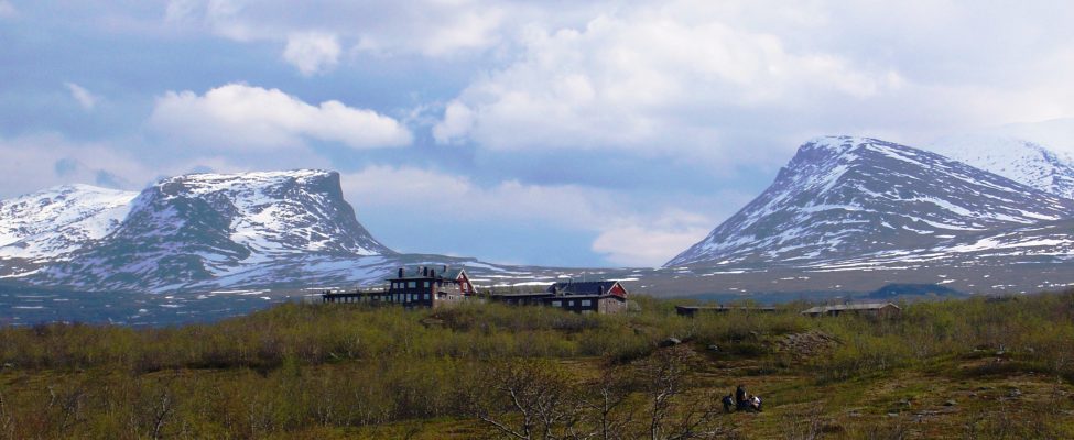
The station is located about 200 km north of the Arctic Circle and approximately 380 m.a.s.l., on the south shore of Lake Torne­träsk. The station is situated in a 46 hectare nature reserve bordering the Abisko National Park, which covers 75 km2. The station is located in mountain birch forest and surrounded my mountains. The village of Abisko (year-round population approx. 150 people) is located nearby. The surrounding area offers a great variety in topo­graphy, geomorphology, geology, and climate, as well as flora and fauna. The highest mountain in the area reaches 1991 m.a.s.l.

Climate data

Grey colours are WMO Climate Normals including maximum and minimum values. Blue colours are individual years.

Climate data for the stations where extracted via Copernicus Climate Data Store, from the global gridded reanalysis product: ERA5 monthly averaged data on single levels from 1940 to present. Description and source code: Roemer J.K. 2023. https://doi.org/10.5281/zenodo.10214922 Data Source: Hersbach et al. 2023. Copernicus Climate Change Service (C3S) Climate Data Store (CDS), https://doi.org/10.24381/cds.f17050d7

Biodiversity and natural environment

The average annual air temperature is approximately 0°C. Annual precipitation along Lake Torneträsk varies greatly over an west-east gradient with 1000 mm in the west to 300 mm in the east. Mean annual air temperature and growing season length have exhibited an increasing trend over the last decades. Vegetation composition is varied, ranging from simple plant communities following retreating glaciers to complex mountain birch forest, heath and meadow tundra ecosystems. About 40% of the surrounding landscape is above the tree line. Ecosystems comprise mountain birch forest, lakes, rivers, streams, mires, wetlands, tundra heath, alpine meadow, high alpine environment, rocky outcrops, and glaciers. The area is underlain by sporadic permafrost, which is located primarily in mire areas. Fauna includes birds, fish, reindeer, moose, snowshoe hare, rodents, red fox, mink, otter, brown bear, wolverine, lynx, aquatic and terrestrial insects. The area is sparsely populated and land use is minimal, dominated by reindeer husbandry, hunting, fishing, tourism, and research.

History and facilities

The Abisko Scientific Research Station was established in 1913. The station can accommodate approx. 75 visitors. Accommodation is available in shared rooms in the main building (2-3 person rooms) and dorm style accommodation in separate buildings (2-4 person rooms). Fully equipped kitchens are available for visitors to prepare their own meals according to a self-catering principle. The station offers laboratory facilities, workshops, storage space (short-term storage only), a library, office space, a lecture theatre, classroom facilities, meeting rooms and logistical support. The village of Abisko is located within a 15-minute walk from the research station, where you will find a well-equipped grocery store, gas station, and train station. Postal service is available at the research station and local grocery store. During tourist seasons (winter and summer), restaurants are available at tourist facilities. Abisko Scientific Research Station also offers access to four off-grid, remote field huts in the surrounding area: two locations west of the station (Latnjajaure (alpine) and Kärkevagge (glacial stream valley)) and two locations on the north shore of Lake Torneträsk (Jieprenkiedde and Lullehatjårro).

General research and databases

Research focuses on natural sciences, including e.g. ecology, biogeochemistry, geomorphology, meteorology, hydrology, and climate science. Ecological studies investigate the dynamics of plant community change, biogeochemical patterns, understanding ecosystem structure and function, and predicting ecosystem responses to climate and environmental change. Ecological studies span a wide range of research fields including plant ecology, botany, biogeochemistry, soil biology, entomology, ornithology, wildlife biology, fish biology, terrestrial and aquatic sciences. Meteorological projects investigate weather patterns, climate change and variations in microclimate. Geomorphological research focuses on permafrost thaw, mass-wasting, sediment transport, glacial retreat. The research station contributes to a research database including an up-to-date bibliography of publications stemming from research in Abisko. The Abisko Scientific Research Station also runs a long-term environmental monitoring programme, dating back to 1913. Included in this programme are a number of meteorological and environmental parameters as well as phenological observations. Furthermore, Abisko Scientitic Research Station is a partner in the long-term monitoring programmes of Swedish Infrastructure for Ecosystem Science (SITES) and Integrated Carbon Observation System (ICOS). All data collected via the monitoring programmes are publicly available.

Link to data: https://dataportal.eu-interact.org/stations

Station Monitoring

Human dimension

The village of Abisko is located approximately 1 km east of the research station. Year-round population is approx. 150 people. The village offers a grocery store, gas station, elementary school (kindergarten to grade 9), and day care. A community interest group organises a series of annual events and activities. Main occupations include tourism, transport, education and research. A number of tourist facilities provide a basis for both summer and winter tourism. The village of Abisko and the Abisko Scientific Research Station are located on the traditional territory of Sápmi, and local Sámi communities use the area for traditional reindeer herding and husbandry.

Access

The Abisko Scientific Research Station is easily accessible by train, car, bus, and airplane. Two passenger trains pass through Abisko per day, from Stockholm, Sweden, and from Narvik, Norway. A road connects Kiruna, Sweden (~90 km), and Narvik, Norway (~75 km). Airports in Kiruna, Sweden (~100 km) and Evenes, Norway (~120 km) offer daily flights to Stockholm and Oslo, respectively. During the summer season, there is also a bus from Kiruna airport to Abisko.

Member of: