Address

Station manager

Mikko Jokinen
E-mail: mikko.jokinen@luke.fi

Contact Station


www.luke.fi/en

Station Features

Opening year: 1964 Status: Open
  • Type of station: Station
  • Operational period – year-round or Month A to Month B: Year-round
  • Name of station owner: Natural Resources Institute Finland
  • Type of owner: Government
  • Name of managing institution: Natural Resources Institute Finland
  • Managing Institution Country: Finland
  • Station owner country:
  • Partner institution: No
  • Station latitude: 67,35269444
  • Station longitude: 23,82706389
  • Country (station location): Finland
  • Altitude of station: 221 m a.s.l
  • Min. altitude within study area: 200 m a.s.l
  • Max. altitude within study area: 800 m a.s.l
  • Nearest town/settlement: Kolari (1500 inhabitants)
  • Distance to nearest town/settlement: 4 km
  • Number of residents in nearest town: 1500
  • Distance to nearest research station: 70 km
  • Maps available at station: Several maps, aerial images, satellite images, open access to digital maps of Finland
  • Climate zone: Sub-Arctic
  • Period of measurments for climate data below [year to year]: Since 2010
  • Mean annual temperature: 0,8 °C
  • Mean temperature in February: -18,4 °C
  • Mean temperature in July: 15,4 °C
  • Precipitation type: Snow, Rain, Hail
  • Lake ice break up: June
  • River ice break up: June
  • Dominant wind direction: South
  • Mean annual wind speed: 2 m/s
  • Maximum wind speed (absolute): 10,1 m/s
  • Landscape features Mountains, Valleys, Lake, River
  • Permafrost zone None
  • Vegetation zone Tree line, Shrub tundra, Forest tundra, Peatlands, Wetlands, Deciduous forest, Evergreen forest
  • Human use Settlement

Facilities

  • Area under roof: 550 m²
  • Max. number of visitors at a time : 10
  • Showers: Yes
  • Laundry facilities: Yes
  • Power supply – period (from ‘hour’ to ‘hour’ or 24 hours): 24 h
  • Power supply - plug type C, F
  • Logistics area: 120 m²
  • Means of transportation to/from station Boat, Car, Train
  • Airstrip (Length × Width) :
  • Transport on land - at station ATV, Snowmobile, Car
  • Number of staff peak season/summer: 6
  • Number of staff off season/winter: 6
  • Staff able to assist (workshops): Yes - if time allows
  • Laboratory area: 36 m²
  • Field to station Mobile phone, Satellite phone
  • Station to outside world Mobile phone, Internet
  • IT Infrastructure Computers, Printer
  • Medical facilities: Yes
  • Medical capability Basic
  • Staff with medical training/doctor When open
  • Distance to hospital (estimated time – hours): 5

Science

  • Transnational Access: No
  • Remote Access: No
  • INTERACT Virtual Access: No
  • Permitting issues categories
    • Permits required for access to the station
    • Permits required for studies
  • Partner institutions (involved in the operation of the station)
    • Partner institution
  • Climate
    • Snow
    • Rain
    • Hail
  • Housing and accomodation
    • Showers
    • Laundry facilities
    • A
    • B
    • C
    • D
    • E
    • F
    • G
    • H
    • I
    • J
    • K
    • L
    • M
    • N
    • O
    • Municipal grid
    • Diesel/oil/gas
    • Wood
    • Solar
    • Wind
    • Water
    • Geothermal
    • Biofuel
    • Other
  • Logistics
    • Electrical and IT technologies
    • Mechanical
    • Metal
    • Wood
    • Plexiglas
    • Other
    • Walk
    • None
    • Tracked vehicle
    • Truck
    • SUV (4x4)
    • Car
    • ATV
    • Zodiac
    • Snowmobile
    • Open boat/Dhinghy
    • Closed boat
    • Bicycles
    • Amphibie vehicle
    • Ski
    • Other
    • Snow shoes
    • KickSledges
    • Other
    • Ski
    • Snowmobile
    • Boat
    • Car
    • Tracked vehicle
    • Truck
    • SUV (4x4)
    • Bus
    • Train
    • Airstrip
    • Scheduled flight
    • Chartered plane/helicopter
    • Helipad
    • Other
    • None
    • Harbour/port
    • Warf/pier
    • Pontoon/float bridge
    • Barges
    • Beach
  • Aircraft landing facilities
    • Helipad
  • Features in the facility area
    • Permanent snowpatches
    • Mountain
    • Valley
    • Lake
    • River
    • Shoreline
    • Tree line
    • Polar deserts/semi-deserts
    • Shrub tundra
    • Gramminoid tundra
    • Forest tundra
    • Peatlands
    • Wetlands
    • Palsa mires
    • Deciduous forest
    • Evergreen forest
    • Human settlements or resource use in the area
    • Arable land
    • Other
  • Main science disciplines
    • Astronomy
    • Atmospheric sciences
    • Cryology
    • Geology
    • Hydrology
    • Limnic biology
    • Marine biology
    • Terrestrial biology
    • Human biology
    • Anthropology
    • Archaeology
    • Sociology
    • Climate change
    • Environmental science (incl. pollution)
    • Oceanography
    • Agriculture
    • Animal husbandry
    • Fisheries
    • Forestry
    • Hunting
    • Tourism
  • Workshop facilities
    • Metal workshop
    • Wood workshop
    • Plexiglas workshop
    • Staff available to assist with constructions
  • Communication
    • Telephone
    • Satellite phone
    • VHF
    • E-mail
    • Internet
    • Computer
    • Printer
    • Scanner
    • Fax
  • Landscape and environment
    • Mountains
    • Nunataks
    • Volcano/crater
    • Lava fields
    • Plateaus
    • Moraines
    • Valleys
    • Homothermic Springs
    • Lake
    • Thermokarst lake
    • River
    • Delta/estuarie
    • Fjord
    • Continuous
    • Sea
    • Discontinuous
    • Beach
    • Sporadic
    • Rocky shores
    • Pingos/ice lenses
    • Sea cliffs
    • Other (text)
    • Palsa mires
    • None
    • Ice Caps
    • Glaciers
    • Permanent snow patches
    • None
    • Tree line
    • Polar desert/Semi-desert
    • Gramminoid tundra
    • Shrub tundra
    • Forest tundra
    • Wetlands
    • Peatlands/mires
    • Salt marshes/lagoons
    • Heath
    • Grassland
    • Deciduous forest
    • Evergreen forest
    • Terrestrial carnivores
    • Alpine heath
    • Ungulates
    • Hares
    • Other (text)
    • Rodents
    • Bird colonies
    • Polar bear
    • Whales
    • Seals
    • Fish
    • Settlement
    • Fishing
    • Hunting
    • Forestry
    • Agriculture
    • Tourism
    • Animal husbandry
    • Leisure activities
  • Laboratory
    • Freezer < -80
    • Freezer -40 - -10
    • Fridge
    • Microscopes
    • Basic laboratory equipment
    • Advanced laboratory equipment
    • Basic chemical reagents
    • Analytical instrumentation
    • Other
    • Laboratory available in nearby town/settlement
  • Communication and IT
    • Mobile phone
    • VHF
    • Satellite phone
    • Other
    • Satellite phone
    • Mobile phone
    • Internet
    • Other
    • Wireless transfer of data from field site to station
    • Wifi
    • Computers
    • Printer
    • Data storage
    • Statistical tools
    • GIS tools
    • Other
  • Medical facilities
    • Medical facilities
    • Basic
    • Medium
    • Extensive
    • Dental
    • Surgery
    • Other
    • No
    • In peak season
    • When open

Station name and owner

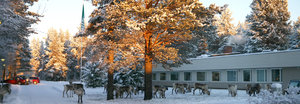
The Kolari Research Unit belongs to the Natural Resources ­Institute Finland.
Location

The Kolari Reseach Unit is located in northwest Finland at 67° N, close to the Swedish border. The surrounding area consists of northern boreal taiga forests and swamps, as well as mountains up to 700 m a.s.l. Kolari village is approximately 4 km, and the Muonio River is approximately 300 meters away from the station. The Pallas-Ylläs National Park is located 30 km from station. With almost half a million annual visitors, it is Finland’s best known national park.

Climate data

Grey colours are WMO Climate Normals including maximum and minimum values. Blue colours are individual years.

Climate data for the stations where extracted via Copernicus Climate Data Store, from the global gridded reanalysis product: ERA5 monthly averaged data on single levels from 1940 to present. Description and source code: Roemer J.K. 2023. https://doi.org/10.5281/zenodo.10214922 Data Source: Hersbach et al. 2023. Copernicus Climate Change Service (C3S) Climate Data Store (CDS), https://doi.org/10.24381/cds.f17050d7

Biodiversity and natural environment

Geographically, the Kolari area is located between Northern Finland, Forest Lapland and Fell Lapland, making it a very varied and interesting habitat. Kolari is situated at the western limit of the Russian taiga. The area is characterised as a mixture zone of eastern and western species of flora and fauna and includes old pine forest, wetlands, lakes, and rivers. Bears, moose, and reindeer are found in the area, the latter both as wild game and domesticated. Snow covers the landscape from November to May.

History and facilities

The Kolari Research Unit was established in 1964 for the study of peat lands. Today we focus on sustainable use of northern timberline forests and integration of different nature-based livelihoods also with respect to rapidly growing mining activities in this area. The station has 15 offices, high speed internet, and guestrooms for visitors. Kolari village offers various services, and a broad range of outdoor activities is possible in the nearby Ylläs National Park.

General research and databases

The research at Kolari focuses on the integration of different nature-based livelihoods at the timberline (tourism, reindeer herding, and forestry), ecologically sustainable forestry, nature protection, and plant ecology. The main objectives of the ecological projects are to study the dynamics of natural forests and disturbance dynamics of forest fires. Existing databases include a bibliography of publications arising from research at the station, as well as long term ecological data concerning timberline regeneration, rodents, seed yield, and phenology.

Station Monitoring

Human dimension

The nearest community is Kolari village (five km away) with approximately 1500 inhabitants. A bit larger is the Swedish Pajala (c. 6200 inhabitants) which is located 30 km from the Kolari Research Unit. Most of the local people are of Finnish origin with long and strong ties to the area and also to the Sami people. The border to the Finnish Sami region is 100 km to the north but it is only two km away from the Swedish Sami region. Tourism and public services are nowadays the main economic factors, but reindeer herding still plays an important role in the area as well as other land uses like forestry and agriculture. Fishing, hunting, and recreational use of the nature are all essential parts of the local culture and provide great opportunities for various outdoor activities.

Access

You can reach Kolari Research Unit easily by car, train or airplane. We are located along Highway 21 from Tornio to Kilpisjärvi. The railway station is less than one km away. Nearest airport is Kittilä Airport 75 km from the station.

Member of: