Address

Alpine Forschungsstation (ALPFOR),
Furka Passhöhe,
CH-6491 Realp,
Switzerland

Station manager

Christian Körner
E-mail: sekretariat-botschoen@unibas.ch

Contact Station

E-mail: sekretariat-botschoen@unibas.ch

http://www.alpfor.ch/general.shtml

Station Features

Opening year: 2009 Status: Open
  • Type of station: Station
  • Operational period – year-round or Month A to Month B: June-September
  • Name of station owner: ALPFOR
  • Type of owner: Government
  • Name of managing institution: ALPFOR
  • Managing Institution Country: Switzerland
  • Station owner country: Switzerland
  • Partner institution: No
  • Station latitude: 46,57666667
  • Station longitude: 8,42138889
  • Country (station location): Switzerland
  • Altitude of station: 2435 m a.s.l
  • Min. altitude within study area: 1500 m a.s.l
  • Max. altitude within study area: 3400 m a.s.l
  • Nearest town/settlement: Andermatt (1300 inhabitants)
  • Distance to nearest town/settlement: 12 km
  • Number of residents in nearest town: 1300
  • Distance to nearest research station: 180 km
  • Maps available at station: 1:25 000
  • Climate zone: Alpine
  • Climate zone: Boreal
  • Period of measurments for climate data below [year to year]:
  • Mean annual temperature: -1,3 °C
  • Mean temperature in February: -8,7 °C
  • Mean temperature in July: 6,4 °C
  • Precipitation type: Snow, Rain
  • Lake ice break up: July
  • Dominant wind direction: West
  • Mean annual wind speed: 8 m/s
  • Maximum wind speed (absolute): 35 m/s
  • Landscape features Mountains, Valleys
  • Permafrost zone Continuous
  • Snow and ice on land Ice Caps, Glaciers, Permanent snow patches
  • Vegetation zone Tree line

Facilities

  • Area under roof: 350 m²
  • Max. number of visitors at a time : 100
  • Showers: Yes
  • Laundry facilities: Yes
  • Power supply – period (from ‘hour’ to ‘hour’ or 24 hours): 24 h
  • Power supply - plug type C, J
  • Logistics area: 80 m²
  • Workshops Wood
  • Means of transportation to/from station Car
  • Airstrip (Length × Width) :
  • Transport on land - at station Car
  • Number of staff peak season/summer: 10
  • Number of staff off season/winter: 0
  • Field to station Mobile phone, Satellite phone
  • Station to outside world Mobile phone, Internet
  • IT Infrastructure Computers, Printer
  • Distance to hospital (estimated time – hours): 12
  • Laboratory area: 80 m²

Science

  • Transnational Access: No
  • Remote Access: No
  • INTERACT Virtual Access: No
  • Permitting issues categories
    • Permits required for access to the station
    • Permits required for studies
  • Partner institutions (involved in the operation of the station)
    • Partner institution
  • Climate
    • Snow
    • Rain
    • Hail
  • Housing and accomodation
    • Showers
    • Laundry facilities
    • A
    • B
    • C
    • D
    • E
    • F
    • G
    • H
    • I
    • J
    • K
    • L
    • M
    • N
    • O
    • Municipal grid
    • Diesel/oil/gas
    • Wood
    • Solar
    • Wind
    • Water
    • Geothermal
    • Biofuel
    • Other
  • Logistics
    • Electrical and IT technologies
    • Mechanical
    • Metal
    • Wood
    • Plexiglas
    • Other
    • Walk
    • None
    • Tracked vehicle
    • Truck
    • SUV (4x4)
    • Car
    • ATV
    • Zodiac
    • Snowmobile
    • Open boat/Dhinghy
    • Closed boat
    • Bicycles
    • Amphibie vehicle
    • Ski
    • Other
    • Snow shoes
    • KickSledges
    • Other
    • Ski
    • Snowmobile
    • Boat
    • Car
    • Tracked vehicle
    • Truck
    • SUV (4x4)
    • Bus
    • Train
    • Airstrip
    • Scheduled flight
    • Chartered plane/helicopter
    • Helipad
    • Other
    • None
    • Harbour/port
    • Warf/pier
    • Pontoon/float bridge
    • Barges
    • Beach
  • Aircraft landing facilities
    • Helipad
  • Features in the facility area
    • Permanent snowpatches
    • Mountain
    • Valley
    • Lake
    • River
    • Shoreline
    • Tree line
    • Polar deserts/semi-deserts
    • Shrub tundra
    • Gramminoid tundra
    • Forest tundra
    • Peatlands
    • Wetlands
    • Palsa mires
    • Deciduous forest
    • Evergreen forest
    • Human settlements or resource use in the area
    • Arable land
    • Other
  • Main science disciplines
    • Astronomy
    • Atmospheric sciences
    • Cryology
    • Geology
    • Hydrology
    • Limnic biology
    • Marine biology
    • Terrestrial biology
    • Human biology
    • Anthropology
    • Archaeology
    • Sociology
    • Climate change
    • Environmental science (incl. pollution)
    • Oceanography
    • Agriculture
    • Animal husbandry
    • Fisheries
    • Forestry
    • Hunting
    • Tourism
  • Workshop facilities
    • Metal workshop
    • Wood workshop
    • Plexiglas workshop
    • Staff available to assist with constructions
  • Communication
    • Telephone
    • Satellite phone
    • VHF
    • E-mail
    • Internet
    • Computer
    • Printer
    • Scanner
    • Fax
  • Landscape and environment
    • Mountains
    • Nunataks
    • Volcano/crater
    • Lava fields
    • Plateaus
    • Moraines
    • Valleys
    • Homothermic Springs
    • Lake
    • Thermokarst lake
    • River
    • Delta/estuarie
    • Fjord
    • Continuous
    • Sea
    • Discontinuous
    • Beach
    • Sporadic
    • Rocky shores
    • Pingos/ice lenses
    • Sea cliffs
    • Other (text)
    • Palsa mires
    • Ice Caps
    • None
    • Glaciers
    • Permanent snow patches
    • None
    • Tree line
    • Polar desert/Semi-desert
    • Gramminoid tundra
    • Shrub tundra
    • Forest tundra
    • Wetlands
    • Peatlands/mires
    • Salt marshes/lagoons
    • Heath
    • Grassland
    • Deciduous forest
    • Evergreen forest
    • Terrestrial carnivores
    • Alpine heath
    • Ungulates
    • Hares
    • Other (text)
    • Rodents
    • Bird colonies
    • Polar bear
    • Whales
    • Seals
    • Fish
    • Settlement
    • Fishing
    • Hunting
    • Forestry
    • Agriculture
    • Tourism
    • Animal husbandry
    • Leisure activities
  • Communication and IT
    • Mobile phone
    • VHF
    • Satellite phone
    • Other
    • Satellite phone
    • Mobile phone
    • Internet
    • Other
    • Wireless transfer of data from field site to station
    • Wifi
    • Computers
    • Printer
    • Data storage
    • Statistical tools
    • GIS tools
    • Other
  • Medical facilities
    • Medical facilities
    • Basic
    • Medium
    • Extensive
    • Dental
    • Surgery
    • Other
    • No
    • In peak season
    • When open
  • Laboratory
    • Freezer < -80
    • Freezer -40 - -10
    • Fridge
    • Microscopes
    • Basic laboratory equipment
    • Advanced laboratory equipment
    • Basic chemical reagents
    • Analytical instrumentation
    • Other
    • Laboratory available in nearby town/settlement

Station name and owner

The ‘Alpine Research and Education Station Furka’ (ALPFOR) is managed by the non-profit association ALPFOR, which is related to the University of Basel.

Location

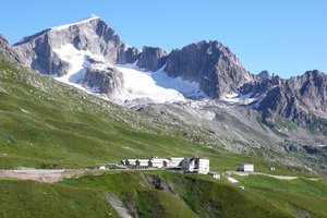
ALPFOR is situated close to the summit of the Furka Pass at an elevation of 2435 m a.s.l. in the Swiss Central Alps, canton Uri (46°34’ N, 8°25’ E). The nearest larger community is Andermatt at the Gotthard Pass Road to Italy with approximately 1300 inhabitants. Land owner is the Korporation Ursern (a regional authority).

Climate data

Grey colours are WMO Climate Normals including maximum and minimum values. Blue colours are individual years.

Climate data for the stations where extracted via Copernicus Climate Data Store, from the global gridded reanalysis product: ERA5 monthly averaged data on single levels from 1940 to present. Description and source code: Roemer J.K. 2023. https://doi.org/10.5281/zenodo.10214922 Data Source: Hersbach et al. 2023. Copernicus Climate Change Service (C3S) Climate Data Store (CDS), https://doi.org/10.24381/cds.f17050d7

Biodiversity and natural environment

ALPFOR is placed in a small zone of mesozoic calcareous layers (‘Ursernzone’) within the granitic, gneissic, and phyllitic (mica schist) core of the central Alps. The pass itself and the summits around, with elevations above 3500 m a.s.l., form the watershed of three major European river systems (Rhone, Rhine, and Po). All glaciers around the Furka Pass are at a rapid retreat, accompanied by permafrost thawing, rock glacier melting, and the release of new terrain from ice. Floristically, the Furka Pass is one of the richest parts of the Alps, i.e. within 1 km around the ALPFOR station, the alpine flora comprises close to 300 species of flowering plants, which is more than half of the total Swiss alpine flora. This biological richness is explained by the local geology and the topographic diversity. By area, the two largest habitats are alpine grassland dominated by Carex curvula and open fell field/rock vegetation. There are wet and very dry microhabitats (cotton grass - Eriophorum sp, and succulents – Sempervivum sp).

History and facilities

ALPFOR adopted three buildings from the former military station in 2008-2011. House Carex (a former health station) is mainly used by permanent staff. It offers beds for 12 people in two storeys. House Rumex (also two-storey) has a small lecture room for 25 people, a ‘Flora galery’ and a little tea-kitchen in the basement, and a 10-bed dormitory in the upper floor. House Ibex (former canteen and accommodation for officers) is a three-storey building with a large kitchen, a dining hall/lecture room for up to 100 people, and eight rooms with 2-4 beds. Several working rooms and modern sanitary facilities are offered in all three houses. ALPFOR can host up to 30 visitors at a time.

General research and databases

The Furka Pass is an ideal region for alpine research. Since 1991, diverse studies have strongly shaped our understanding of the alpine ecosystem, which contributed to ‘Alpine Plant Life’ (Ch. Körner, Springer Publishers, 2003). Major research projects at ALPFOR deal with the influence of elevated CO2 concentration on growth, productivity, and water relations of alpine grassland and glacier forefield vegetation; the impact of nitrogen deposition, climatic warming, and sheep trampling on alpine grassland; microclimatology of alpine vegetation; population biology and reproductive ecology of alpine plants; molecular genetics of alpine plant populations (gene-ecology); hydrological consequences of land use change. For an overview on these research projects see: http://pages.unibas.ch/botschoen/alpfor/research.shtml. We offer alpine ecology summer courses to undergraduate and graduate students. Our students prepare for the summer school through a web-based teaching tool (English and Spanish version) that is freely offered to all users (www.alpandino.org).

Station Monitoring

Human dimension

The major human influence in this area is pastoralism, which have existed here for more than a thousand years and is currently in rapid decline at lower elevations (with massive Alnus shrub encroachment). Higher elevations are facing uncontrolled increases in the number of sheep, leading to an intensification of grazing on the remaining, easily accessible parcels. The Alnus problem is the most immediate threat, because it leads to soil acidification, nitrogen eutrophication, plant diversity decline and it prevents natural reforestation by indigenous species (pristine forest was cleared already in the 11th century).

Access

The Furka Pass Road is open from May to October. The station is open from the 1st of June to the 30th September. There is a postbus service from Andermatt and Oberwald twice a day from each side of the pass. Andermatt and Oberwald have train stations less than 15 km away from the Furka pass. The link to the main Swiss rail system is at Göschenen. A trip from Basel or Zurich takes approximately three hours.

Member of: