Address

Endowment Fund Adygine
Znojemska 78
586 01 Jihlava
Czech Republic

Station manager

Sergey Alaksandrovich Yerokhin
E-mail: s.yerokhin@adygine.com

Station Features

Opening year: 2008 Status: Open
  • Type of station: Station
  • Operational period – year-round or Month A to Month B: Year-round
  • Name of station owner: Institute of water problems and Hydropower
  • Type of owner: NGO
  • Name of managing institution: Institute of water problems and Hydropower
  • Managing Institution Country: Kyrgyz Republic (Kyrgyzstan)
  • Station owner country: Czech Republic
  • Partner institution: No
  • Station latitude: 42,51262778
  • Station longitude: 74,43831389
  • Country (station location): Kyrgyz Republic (Kyrgyzstan)
  • Altitude of station: 3600 m a.s.l
  • Min. altitude within study area: 3200 m a.s.l
  • Max. altitude within study area: 4200 m a.s.l
  • Nearest town/settlement: Kashka-Suu
  • Distance to nearest town/settlement: 40 km
  • Number of residents in nearest town: 1000
  • Distance to nearest research station: 1330 km
  • Maps available at station: Map (1:50 000), aerial image, satellite image, Google Earth
  • Climate zone: Alpine
  • Period of measurments for climate data below [year to year]: Since 2008
  • Mean annual temperature: -1 °C
  • Mean temperature in February: -15 °C
  • Mean temperature in July: 9 °C
  • Precipitation type: Rain, snow
  • Dominant wind direction: North
  • Mean annual wind speed: 5 m/s
  • Maximum wind speed (absolute): 40 m/s
  • Landscape features Mountains, Moraines, Valleys, Lake, River
  • Permafrost zone None
  • Snow and ice on land Glaciers
  • Human use Settlement

Facilities

  • Area under roof: 49 m²
  • Max. number of visitors at a time : 16
  • Showers: Yes
  • Laundry facilities: No
  • Power supply – period (from ‘hour’ to ‘hour’ or 24 hours): 24 Hours
  • Power supply - plug type C, F
  • Power sources at station Wind, Other
  • Airstrip (Length × Width) :
  • Number of staff peak season/summer: 2
  • Number of staff off season/winter: 2
  • Laboratory area: 49 m²
  • Field to station Mobile phone
  • Station to outside world Mobile phone
  • IT Infrastructure Computers
  • Medical capability Basic
  • Distance to hospital (estimated time – hours): 10

Science

  • Transnational Access: No
  • Remote Access: No
  • INTERACT Virtual Access: No
  • Permitting issues categories
    • Permits required for access to the station
    • Permits required for studies
  • Partner institutions (involved in the operation of the station)
    • Partner institution
  • Climate
    • Snow
    • Rain
    • Hail
  • Housing and accomodation
    • Showers
    • Laundry facilities
    • A
    • B
    • C
    • D
    • E
    • F
    • G
    • H
    • I
    • J
    • K
    • L
    • M
    • N
    • O
    • Municipal grid
    • Diesel/oil/gas
    • Wood
    • Solar
    • Wind
    • Water
    • Geothermal
    • Biofuel
    • Other
  • Logistics
    • Electrical and IT technologies
    • Mechanical
    • Metal
    • Wood
    • Plexiglas
    • Other
    • Walk
    • None
    • Tracked vehicle
    • Truck
    • SUV (4x4)
    • Car
    • ATV
    • Zodiac
    • Snowmobile
    • Open boat/Dhinghy
    • Closed boat
    • Bicycles
    • Amphibie vehicle
    • Ski
    • Other
    • Snow shoes
    • KickSledges
    • Other
    • Ski
    • Snowmobile
    • Boat
    • Car
    • Tracked vehicle
    • Truck
    • SUV (4x4)
    • Bus
    • Train
    • Airstrip
    • Scheduled flight
    • Chartered plane/helicopter
    • Helipad
    • Other
    • None
    • Harbour/port
    • Warf/pier
    • Pontoon/float bridge
    • Barges
    • Beach
  • Aircraft landing facilities
    • Helipad
  • Features in the facility area
    • Permanent snowpatches
    • Mountain
    • Valley
    • Lake
    • River
    • Shoreline
    • Tree line
    • Polar deserts/semi-deserts
    • Shrub tundra
    • Gramminoid tundra
    • Forest tundra
    • Peatlands
    • Wetlands
    • Palsa mires
    • Deciduous forest
    • Evergreen forest
    • Human settlements or resource use in the area
    • Arable land
    • Other
  • Main science disciplines
    • Astronomy
    • Atmospheric sciences
    • Cryology
    • Geology
    • Hydrology
    • Limnic biology
    • Marine biology
    • Terrestrial biology
    • Human biology
    • Anthropology
    • Archaeology
    • Sociology
    • Climate change
    • Environmental science (incl. pollution)
    • Oceanography
    • Agriculture
    • Animal husbandry
    • Fisheries
    • Forestry
    • Hunting
    • Tourism
  • Workshop facilities
    • Metal workshop
    • Wood workshop
    • Plexiglas workshop
    • Staff available to assist with constructions
  • Communication
    • Telephone
    • Satellite phone
    • VHF
    • E-mail
    • Internet
    • Computer
    • Printer
    • Scanner
    • Fax
  • Landscape and environment
    • Mountains
    • Nunataks
    • Volcano/crater
    • Lava fields
    • Plateaus
    • Moraines
    • Valleys
    • Homothermic Springs
    • Lake
    • Thermokarst lake
    • River
    • Delta/estuarie
    • Fjord
    • Continuous
    • Sea
    • Discontinuous
    • Beach
    • Sporadic
    • Rocky shores
    • Pingos/ice lenses
    • Sea cliffs
    • Other (text)
    • Palsa mires
    • None
    • Ice Caps
    • Glaciers
    • Permanent snow patches
    • None
    • Tree line
    • Polar desert/Semi-desert
    • Gramminoid tundra
    • Shrub tundra
    • Forest tundra
    • Wetlands
    • Peatlands/mires
    • Salt marshes/lagoons
    • Heath
    • Grassland
    • Deciduous forest
    • Evergreen forest
    • Terrestrial carnivores
    • Alpine heath
    • Ungulates
    • Hares
    • Other (text)
    • Rodents
    • Bird colonies
    • Polar bear
    • Whales
    • Seals
    • Fish
    • Settlement
    • Fishing
    • Hunting
    • Forestry
    • Agriculture
    • Tourism
    • Animal husbandry
    • Leisure activities
  • Laboratory
    • Freezer < -80
    • Freezer -40 - -10
    • Fridge
    • Microscopes
    • Basic laboratory equipment
    • Advanced laboratory equipment
    • Basic chemical reagents
    • Analytical instrumentation
    • Other
    • Laboratory available in nearby town/settlement
  • Communication and IT
    • Mobile phone
    • VHF
    • Satellite phone
    • Other
    • Satellite phone
    • Mobile phone
    • Internet
    • Other
    • Wireless transfer of data from field site to station
    • Wifi
    • Computers
    • Printer
    • Data storage
    • Statistical tools
    • GIS tools
    • Other
  • Medical facilities
    • Medical facilities
    • Basic
    • Medium
    • Extensive
    • Dental
    • Surgery
    • Other
    • No
    • In peak season
    • When open

Station name and owner

Adygine Research Station belongs to Institute of Water Problem and Hydropower, Kyrgyz National Academy of Science in Kyrgyz Republic.

Location

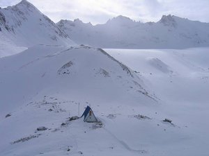
Adygine Research Station is situated in Northern Tchein-Shan on the northern slope of the Kyrgyz mountain range and in the &shy;National Nature Park Ala-Aracha. The study area is a glacier-&shy;moraine complex lying at an altitude of 3400 &ndash; 4200 m a.s.l.

Climate data

Grey colours are WMO Climate Normals including maximum and minimum values. Blue colours are individual years.

Climate data for the stations where extracted via Copernicus Climate Data Store, from the global gridded reanalysis product: ERA5 monthly averaged data on single levels from 1940 to present. Description and source code: Roemer J.K. 2023. https://doi.org/10.5281/zenodo.10214922 Data Source: Hersbach et al. 2023. Copernicus Climate Change Service (C3S) Climate Data Store (CDS), https://doi.org/10.24381/cds.f17050d7

Biodiversity and natural environment

The climate near the station area is polar to sub-polar. The area consists of tundra with mosses, lichens, and unique flowers, even red listed species. The fauna consists of e.g. wild goats, yaks, and snow leopard (irbis).

History and facilities

The station was built in 2008. The building of the station has been designed as the letter ‘A’ and has the dimensions 6.5 × 7 m. The station can accommodate six-eight persons. All energy for running the station is mostly generated by a wind turbine unit and solar panels.

General research and databases

Monitoring of lakes: Changes in lake size, shape, and water level are monitored. All changes in morphology of moraine dams are also monitored. Meteorological observations: Two weather stations are installed in the study area. One is situated near the building at lake level and the other above the glacier at an elevation of 3830 m a.s.l. Glaciological studies: Monitoring of glacier retreat and changes in its volume. Hydrological studies: Hydrological research is an integral part of the monitoring of the development of lakes and their inflows and outflows. Other investigations: In addition to studies carried out by station staff, the station is also open to Kyrgyz and foreign scientists as a platform for different types of research.

Station Monitoring

Human dimension

The station is located only 40 km from the capital of Kyrgyzstan, Bishkek city.

Access

Bishkek airport can be reached by air in 40 minutes. From Bishkek, the research station can be reached by car through the main Ala-Archa valley (40 km). The last nine km to the station is by trail either on foot or on horseback.

Member of: