Canadian High Arctic Research Station campus
Address
Canadian High Arctic Research Station campusPolar Knowledge Canada
PO 2150, Cambridge Bay, Nunavut, Canada
X0B 0C0
Station manager
Scott JohnsonContact Station
https://www.canada.ca/en/polar-knowledge.htmlStation Features
Opening year: 2019 Status: OpenFacilities
Station name and owner
<p class="MsoNormal" style="margin-bottom: .0001pt; line-height: normal;"><span style="font-size: 10.5pt; font-family: 'Helvetica',sans-serif; mso-fareast-font-family: 'Times New Roman'; color: #333333; background: white;">The Canadian High Arctic Research Station (CHARS) campus is owned and managed by POLAR Knowledge Canada, a federal Canadian agency.</span></p>
Location
The Canadian High Arctic Research Station (CHARS) campus is located in Cambridge Bay, Kitikmeot Region, Nunavut. The Kitikmeot hamlet’s central northern location provides good access to all parts of the Canadian Arctic. The main CHARS campus is located on the Plateau site in Cambridge Bay, on a slope overlooking the community and the bay. The site is close to other major infrastructure, including the community core.
Climate data
Grey colours are WMO Climate Normals including maximum and minimum values. Blue colours are individual years.
Climate data for the stations where extracted via Copernicus Climate Data Store, from the global gridded reanalysis product:
ERA5 monthly averaged data on single levels from 1940 to present.
Description and source code: Roemer J.K. 2023. https://doi.org/10.5281/zenodo.10214922
Data Source: Hersbach et al. 2023. Copernicus Climate Change Service (C3S) Climate Data Store (CDS), https://doi.org/10.24381/cds.f17050d7
Biodiversity and natural environment
The climate in the Cambridge Bay area is characterised by a high degree of continentality, demonstrated by a large mean annual temperature range (range of ~45°C) and some of the lowest annual precipitation amounts (100–150 mm) encountered in the Canadian Arctic Islands. The annual mean temperature in Cambridge Bay increased by 1.1°C (1961-2010), with most of the warming occurring during the winter months. The bedrock in the Cambridge Bay region and southeastern Victoria Island is Cambrian limestone, and the region hosts a wide range of peri­glacial landforms, e.g. patterned grounds, solifluction lobes, and thermokarst lakes. Permafrost is nearly continuous, with active layers during summer being <1 m. Bioclimatically, the region is part of the Low Arctic, characterised by a moist tundra with low shrubs, forbs, grasses, and cryptogams. The vascular flora consists of c. 150 plant species. The arthropod fauna around Cambridge Bay is relatively diverse and consists of hundreds of insect and spider species. Cambridge Bay is an important fishing area for arctic char and lake trout, and has a small commercial fishery. Southern Victoria Island is an important staging and nesting area for many migratory birds, particularly waders (shorebirds). It also has sizeable populations of caribou, muskox, arctic hare, arctic fox, and arctic wolf.
History and facilities
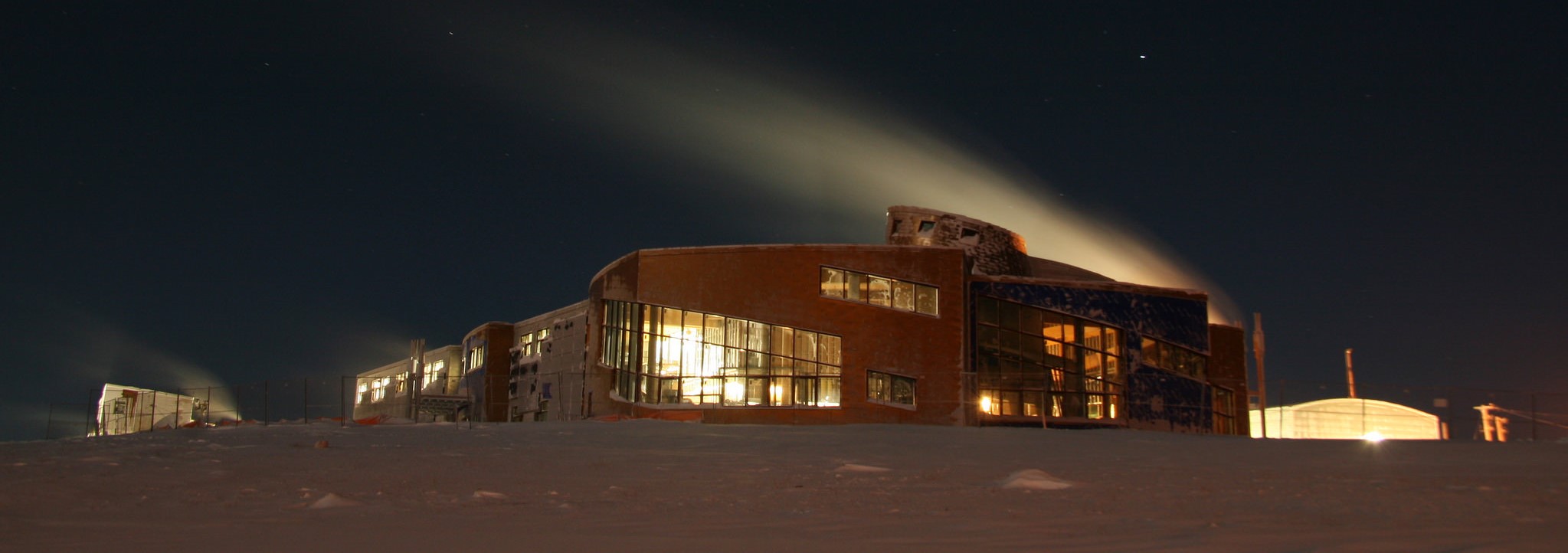
<p class="MsoNormal" style="margin-bottom: .0001pt; line-height: normal;"><span style="font-size: 10.5pt; font-family: 'Helvetica',sans-serif; mso-fareast-font-family: 'Times New Roman'; color: #333333; background: white;">The Canadian High Arctic Research Station (CHARS) campus was first announced in 2007. Construction of the infrastructure began in 2014 and the station officially opened to the public in 2019. It will establish a world-class hub for science and technology in Canada’s North that connects a network of regional facilities. The station will provide a suite of services for Science and Technology (S&T) in Canada’s North, including a technology development centre, knowledge sharing centre, and advanced laboratories. The S&T Program will ensure the new infrastructure supports the current S&T Framework for 2020-2025, a five-year planning cycle, developed for guiding the S&T Program to concrete, measurable results, and to address national priorities.</span></p>
General research and databases
<p class="MsoNormal" style="margin-bottom: .0001pt; line-height: normal;"><span style="font-size: 10.5pt; font-family: 'Helvetica',sans-serif; mso-fareast-font-family: 'Times New Roman'; color: #333333; background: white;">POLAR’s latest S&T Framework – 2020-2025 – sets the context for an implementation plan that will be co-developed by POLAR and its partners. This Framework outlines the following goals: (i) Improving knowledge of dynamic northern terrestrial, freshwater and marine ecosystems in the context of rapid change; (ii) Increasing understanding of the connections between northern community wellness and environmental health; and (iii) Advancing sustainable energy, technology and infrastructure solutions for the unique environmental, social and cultural conditions in the North.</span></p>
Link to data: https://dataportal.eu-interact.org/stations
Station Monitoring
Human dimension
Cambridge Bay (Iqaluktuttiaq in Inuinnaqtun, meaning “good fishing place”) is a hamlet located on Victoria Island in the Kitikmeot Region of Nunavut, Canada. The hamlet has a population of c. 1600 people of which about 80% are Inuit. The community is the largest stop for passenger and research vessels traversing the Arctic Ocean’s Northwest Passage. Situated between Dease Strait and Queen Maud Gulf on the southeast coast of Victoria Island, part of the Canadian Arctic Archipelago, Cambridge Bay is a transportation and administrative centre for the Kitikmeot Region. The area was a traditional hunting and fishing location and archaeological sites are often found. Barrenground caribou, muskox, arctic char, lake trout, and ringed seal were and remain important primary food sources.
Access
The only passenger services are through the Cambridge Bay Airport with daily air service to Yellowknife, and to the other Kitikmeot Region communities. Although Cambridge Bay lies on the Northwest Passage there are no passenger ships other than tourist cruises and annual sealift to the community. Charter and MEDIVAC (air ambulance) services are available.