Address

The Mars Society
11111 W 8th Ave.,
Suite A, Lakewood,
CO 80215,USA

Station manager

Susan Holden Martin
E-mail: susanm@marssociety.org

Contact Station


www.fmars.marssociety.org

Station Features

Opening year: 2001 Status: Open
  • Type of station: Station
  • Operational period – year-round or Month A to Month B: Arctic summer; proposed year-round
  • Name of station owner: The Mars Society, Inc.
  • Type of owner: NGO
  • Name of managing institution: The Mars Society, Inc.
  • Managing Institution Country: United States
  • Station owner country: United States
  • Partner institution: No
  • Station latitude: 75,43131944
  • Station longitude: -89,82338611
  • Country (station location): Canada
  • Altitude of station: 60 m a.s.l
  • Min. altitude within study area: 0 m a.s.l
  • Max. altitude within study area: 400 m a.s.l
  • Nearest town/settlement: Resolute Bay
  • Distance to nearest town/settlement: 145 km
  • Number of residents in nearest town: 300
  • Distance to nearest research station: 390 km
  • Maps available at station: Please contact the station manager for additional resources
  • Climate zone: High Arctic
  • Period of measurments for climate data below [year to year]:
  • Mean annual temperature: -16 °C
  • Mean temperature in February: 0 °C
  • Mean temperature in July: 5 °C
  • Precipitation type: Snow, Rain
  • Mean annual wind speed: 0 m/s
  • Maximum wind speed (absolute): 0 m/s
  • Landscape features Mountains
  • Permafrost zone Continuous
  • Snow and ice on land Permanent snow patches
  • Vegetation zone Polar desert/Semi-desert

Facilities

  • Area under roof: 60 m²
  • Max. number of visitors at a time : 7
  • Showers: Yes
  • Laundry facilities: No
  • Power supply – period (from ‘hour’ to ‘hour’ or 24 hours): 24 hours
  • Power supply - plug type A, B
  • Power sources at station Diesel/oil/gas
  • Logistics area: 160 m²
  • Means of transportation to/from station Chartered plane/helicopter
  • Air transport landing facilities at station Airstrip
  • Airstrip (Length × Width) : 370 × 18 m
  • Airstrip surface : Gravel/Sand
  • Transport on land - at station ATV, Snowmobile
  • Number of staff peak season/summer: 0
  • Number of staff off season/winter: 0
  • Staff able to assist (fieldwork): No
  • Staff able to assist (workshops): No
  • Compulsory safety equipment Satellite phone, GPS
  • Recommended safety equipment Satellite phone, Weapon/rifle
  • Laboratory area: 60 m²
  • Field to station Satellite phone
  • Station to outside world Internet
  • IT Infrastructure Wifi, Computers, Printer
  • Medical facilities: Yes
  • Medical capability Basic
  • Staff with medical training/doctor When open
  • Distance to hospital (estimated time – hours): 145

Science

  • Transnational Access: No
  • Remote Access: No
  • INTERACT Virtual Access: No
  • Permitting issues categories
    • Permits required for access to the station
    • Permits required for studies
  • Partner institutions (involved in the operation of the station)
    • Partner institution
  • Climate
    • Snow
    • Rain
    • Hail
  • Housing and accomodation
    • Showers
    • Laundry facilities
    • A
    • B
    • C
    • D
    • E
    • F
    • G
    • H
    • I
    • J
    • K
    • L
    • M
    • N
    • O
    • Municipal grid
    • Diesel/oil/gas
    • Wood
    • Solar
    • Wind
    • Water
    • Geothermal
    • Biofuel
    • Other
  • Logistics
    • Electrical and IT technologies
    • Mechanical
    • Metal
    • Wood
    • Plexiglas
    • Other
    • Walk
    • None
    • Tracked vehicle
    • Truck
    • SUV (4x4)
    • Car
    • ATV
    • Zodiac
    • Snowmobile
    • Open boat/Dhinghy
    • Closed boat
    • Bicycles
    • Amphibie vehicle
    • Ski
    • Other
    • Snow shoes
    • KickSledges
    • Other
    • Ski
    • Snowmobile
    • Boat
    • Car
    • Tracked vehicle
    • Truck
    • SUV (4x4)
    • Bus
    • Train
    • Airstrip
    • Scheduled flight
    • Chartered plane/helicopter
    • Helipad
    • Other
    • None
    • Harbour/port
    • Warf/pier
    • Pontoon/float bridge
    • Barges
    • Beach
  • Aircraft landing facilities
    • Helipad
  • Features in the facility area
    • Permanent snowpatches
    • Mountain
    • Valley
    • Lake
    • River
    • Shoreline
    • Tree line
    • Polar deserts/semi-deserts
    • Shrub tundra
    • Gramminoid tundra
    • Forest tundra
    • Peatlands
    • Wetlands
    • Palsa mires
    • Deciduous forest
    • Evergreen forest
    • Human settlements or resource use in the area
    • Arable land
    • Other
  • Main science disciplines
    • Astronomy
    • Atmospheric sciences
    • Cryology
    • Geology
    • Hydrology
    • Limnic biology
    • Marine biology
    • Terrestrial biology
    • Human biology
    • Anthropology
    • Archaeology
    • Sociology
    • Climate change
    • Environmental science (incl. pollution)
    • Oceanography
    • Agriculture
    • Animal husbandry
    • Fisheries
    • Forestry
    • Hunting
    • Tourism
  • Workshop facilities
    • Metal workshop
    • Wood workshop
    • Plexiglas workshop
    • Staff available to assist with constructions
  • Communication
    • Telephone
    • Satellite phone
    • VHF
    • E-mail
    • Internet
    • Computer
    • Printer
    • Scanner
    • Fax
  • Meteorology
    • Air temperature
    • Air humidity
    • Air pressure
    • Wind velocity
    • Wind direction
    • Precipitation
  • Energy balance and radiation
    • Energy balance
    • Short wave incoming
    • Short wave outgoing
    • Long wave incoming
    • Long wave outgoing
    • Net radiation
    • UV-B
    • Multi-spectral
    • Cloud cover/hours of sunshine
  • Geology/Geomorphology
    • Quaternary geology
    • Sedimentology
    • Bedrock geology
    • Erosion
  • Sub-surface characteristics
    • Ground surface temperature
    • Soil temperature
    • Soil moisture
    • Ground water table
    • Soil water chemistry
    • Active layer depth
    • Permafrost distribution
    • Permafrost thickness
    • Permafrost temperature
  • Vegetation
    • Flowering phenology
    • Amount of flowering
    • NDVI (plot/transect)
    • Landscape NDVI (from satellite images)
    • Vascular plant community composition
    • Bryophyte community composition
    • Lichen community composition
    • Fungi community composition
    • Berry production
    • Aerobiological monitoring (pollen, spores, etc.)
    • Species list (community composition)
  • Microbiology
    • Interstitial fauna
    • Species list (community composition)
  • Landscape and environment
    • Mountains
    • Nunataks
    • Volcano/crater
    • Lava fields
    • Plateaus
    • Moraines
    • Valleys
    • Homothermic Springs
    • Lake
    • Thermokarst lake
    • River
    • Delta/estuarie
    • Fjord
    • Continuous
    • Sea
    • Discontinuous
    • Beach
    • Sporadic
    • Rocky shores
    • Pingos/ice lenses
    • Sea cliffs
    • Other (text)
    • Palsa mires
    • Ice Caps
    • None
    • Glaciers
    • Permanent snow patches
    • None
    • Tree line
    • Polar desert/Semi-desert
    • Gramminoid tundra
    • Shrub tundra
    • Forest tundra
    • Wetlands
    • Peatlands/mires
    • Salt marshes/lagoons
    • Heath
    • Grassland
    • Deciduous forest
    • Evergreen forest
    • Terrestrial carnivores
    • Alpine heath
    • Ungulates
    • Hares
    • Other (text)
    • Rodents
    • Bird colonies
    • Polar bear
    • Whales
    • Seals
    • Fish
    • Settlement
    • Fishing
    • Hunting
    • Forestry
    • Agriculture
    • Tourism
    • Animal husbandry
    • Leisure activities
  • Field equipment
    • PLB
    • VHF
    • HF
    • Satellite phone
    • Mobile phone
    • GPS
    • Weapon/rifle
    • Flare gun
    • Bearspray
    • PLB
    • First aid kit
    • Glacier rescue kit
    • VHF
    • Avalanche rescue kit
    • HF
    • Satellite phone
    • Overnight equipment
    • Other
    • Mobile phone
    • GPS
    • Weapon/rifle
    • Flare gun
    • Bearspray
    • PLB
    • First aid kit
    • Glacier rescue kit
    • VHF
    • Avalanche rescue kit
    • HF
    • Satellite phone
    • Overnight equipment
    • Other
    • Mobile phone
    • GPS
    • Weapon/rifle
    • Flare gun
    • Bearspray
    • Tent
    • First aid kit
    • Glacier rescue kit
    • Sleeping matress
    • Avalanche rescue kit
    • Sleeping bag
    • Cooking equipment and utensils
    • Overnight equipment
    • Other
    • Gas/alcohol for cooking
    • Field power supply available at station
  • Laboratory
    • Freezer < -80
    • Freezer -40 - -10
    • Fridge
    • Microscopes
    • Basic laboratory equipment
    • Advanced laboratory equipment
    • Basic chemical reagents
    • Analytical instrumentation
    • Other
    • Laboratory available in nearby town/settlement
  • Communication and IT
    • Mobile phone
    • VHF
    • Satellite phone
    • Other
    • Satellite phone
    • Mobile phone
    • Internet
    • Other
    • Wireless transfer of data from field site to station
    • Wifi
    • Computers
    • Printer
    • Data storage
    • Statistical tools
    • GIS tools
    • Other
  • Medical facilities
    • Medical facilities
    • Basic
    • Medium
    • Extensive
    • Dental
    • Surgery
    • Other
    • No
    • In peak season
    • When open

Station name and owner

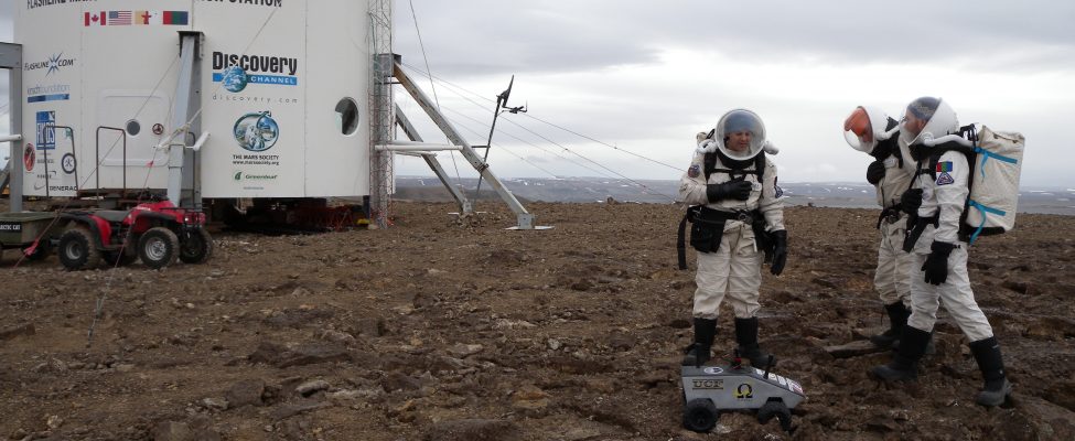
Flashline Mars Arctic Research Station is one of two simulated Mars habitats owned and operated by The Mars Society, Inc. – a U.S. non-profit organisation.
Location

The station is located on Devon Island, a Mars analog environment and polar desert, approximately 165 km northeast of the hamlet of Resolute in Nunavut, Canada (75°25’ N, 89°49’ W). The station is situated on Haynes Ridge, overlooking the Haughton impact crater, a 23 km diameter crater formed approximately 39 million years ago (late Eocene). The location is approximately 1609 km from the Geographic North Pole and approximately 1287 km from the Magnetic North Pole.

Climate data

Grey colours are WMO Climate Normals including maximum and minimum values. Blue colours are individual years.

Climate data for the stations where extracted via Copernicus Climate Data Store, from the global gridded reanalysis product: ERA5 monthly averaged data on single levels from 1940 to present. Description and source code: Roemer J.K. 2023. https://doi.org/10.5281/zenodo.10214922 Data Source: Hersbach et al. 2023. Copernicus Climate Change Service (C3S) Climate Data Store (CDS), https://doi.org/10.24381/cds.f17050d7

Biodiversity and natural environment

Because of its relatively high elevation and its extreme northern latitude, Devon Island supports only a meagre population of small birds and mammals, including muskoxen. Animal life is concentrated in the Truelove Lowland area of the island, which has a favorable microclimate and supports relatively lush arctic vegetation. Temperatures during the brief growing season seldom exceed 10 °C and in winter can plunge to as low as -50 °C. With a polar desert ecology, Devon Island receives very little precipitation. Cape Liddon is an Important Bird Area (IBA) notable for its black guillemot and northern fulmar populations. Cape Vera, another IBA site, is also noted for its northern fulmar population. Devon Island is also notable for the presence of the Haughton impact crater, created some 39 million years ago when a meteorite about 2 km in diameter crashed into what were then forests. The impact left a crater approximately 23 km in diameter, which was a lake for several million years.

History and facilities

The Flashline Station was built by The Mars Society in 2001, and since then it has been used to conduct planetology studies: geological, biological, and climatology studies under conditions similar to those found on Mars, and to develop field tactics based on those explorations, to test habitat design features, tools, and technologies, and to assess crew selection protocols essential to future human spaceflight.

General research and databases

Experiments at Flashline primarily focus on biodiversity surveys of the arctic desert and geological/geophysical study of the Haughton Crater area. Other experiments included a geophysical analysis of Haughton Crater which answered key questions on the physical characteristics of the 20-million year old meteor crater and examined microfossils in crater soil deposits. Logistics and engineering experiments are also conducted.

Station Monitoring

Human dimension

The Mars Society invites researchers to live and work at the station, typically for one month during the arctic summer. Expeditions typically consist of a crew of between six and seven individuals. Typically 1 to 2 months prior to departing for the Canadian Arctic, the crew gathers for an initial face-to-face meeting and training session in Colorado, USA. The station’s primary mission is to help develop key knowledge needed to prepare for human Mars exploration, and to inspire the public by making real the vision of human exploration of Mars. The station is 165 km northeast of Resolute/ Qausuittuq, Nunavut, where 80% of the population is Inuit.

Access

Due to the harsh and dangerous environment of the Arctic, crew members must file an application for consideration and complete orientation and training prior to visiting the station. Crew members must travel by commercial airline to Resolute Bay, Canada. There they spend a few days organizing supplies and equipment and conducting some final training while waiting for clear weather. They then board a Twin Otter aircraft for the final leg of the journey to Devon Island. The primary means of crew transportation while on the island is by ATVs.

Member of: