Address

Ward Hunt Island
Quttinirpaaq National Park
Nunavut
Canada

Station manager

Mickael Lemay
E-mail: mickael.lemay@cen.ulaval.ca

Station Features

Opening year: 1998 Status: Open
  • Type of station: Station
  • Operational period – year-round or Month A to Month B: May-August
  • Name of station owner: CEN/Université Laval in collaboration with Parks Canada
  • Type of owner: Government
  • Name of managing institution: CEN/Université Laval and Parks Canada
  • Managing Institution Country: Canada
  • Station owner country: Canada
  • Partner institution: Yes
  • Partner institution name: Parks Canada
  • Station latitude: 83,07681944
  • Station longitude: -74,20753889
  • Country (station location): Canada
  • Altitude of station: 5 m a.s.l
  • Min. altitude within study area: 0 m a.s.l
  • Max. altitude within study area: 400 m a.s.l
  • Nearest town/settlement: Grise Fjord
  • Distance to nearest town/settlement: 800 km
  • Number of residents in nearest town: 150
  • Distance to nearest research station: 393 km
  • Maps available at station: Aerial image, Google Earth
  • Climate zone: High Arctic
  • Period of measurments for climate data below [year to year]: Since 1995
  • Mean annual temperature: -17,3 °C
  • Mean temperature in February: -33 °C
  • Mean temperature in July: -1 °C
  • Precipitation type: Snow, Rain, Hail
  • Sea ice break up: August, September
  • Dominant wind direction: South
  • Mean annual wind speed: 3,3 m/s
  • Maximum wind speed (absolute): 29 m/s
  • Landscape features Mountains, Valleys, Lake, River, Fjord, Sea
  • Permafrost zone Continuous
  • Snow and ice on land Glaciers, Permanent snow patches
  • Vegetation zone Polar desert/Semi-desert, Wetlands

Facilities

  • Area under roof: 50 m²
  • Max. number of visitors at a time : 9
  • Showers: No
  • Laundry facilities: No
  • Power supply – period (from ‘hour’ to ‘hour’ or 24 hours): 24 hours
  • Power supply - plug type A, B
  • Power sources at station Other
  • Logistics area: 25 m²
  • Means of transportation to/from station Chartered plane/helicopter
  • Air transport landing facilities at station Airstrip, Helipad
  • Airstrip (Length × Width) : 300 × 40 m
  • Airstrip surface : Gravel/Sand
  • Transport on water - at station Zodiac, Open boat/Dhinghy
  • Number of staff peak season/summer: 0
  • Number of staff off season/winter: 0
  • Compulsory safety equipment Satellite phone, Weapon/rifle
  • Laboratory area: 25 m²
  • Field to station VHF, Satellite phone
  • Station to outside world Other
  • Distance to hospital (estimated time – hours): 2000

Science

  • Transnational Access: No
  • Remote Access: No
  • INTERACT Virtual Access: No
  • Permitting issues categories
    • Permits required for access to the station
    • Permits required for studies
  • Partner institutions (involved in the operation of the station)
    • Partner institution
  • Climate
    • Snow
    • Rain
    • Hail
  • Housing and accomodation
    • Showers
    • Laundry facilities
    • A
    • B
    • C
    • D
    • E
    • F
    • G
    • H
    • I
    • J
    • K
    • L
    • M
    • N
    • O
    • Municipal grid
    • Diesel/oil/gas
    • Wood
    • Solar
    • Wind
    • Water
    • Geothermal
    • Biofuel
    • Other
  • Logistics
    • Electrical and IT technologies
    • Mechanical
    • Metal
    • Wood
    • Plexiglas
    • Other
    • Walk
    • None
    • Tracked vehicle
    • Truck
    • SUV (4x4)
    • Car
    • Zodiac
    • ATV
    • Open boat/Dhinghy
    • Snowmobile
    • Closed boat
    • Bicycles
    • Amphibie vehicle
    • Ski
    • Other
    • Snow shoes
    • KickSledges
    • Other
    • Ski
    • Snowmobile
    • Boat
    • Car
    • Tracked vehicle
    • Truck
    • SUV (4x4)
    • Bus
    • Train
    • Airstrip
    • Scheduled flight
    • Chartered plane/helicopter
    • Helipad
    • Other
    • None
    • Harbour/port
    • Warf/pier
    • Pontoon/float bridge
    • Barges
    • Beach
  • Aircraft landing facilities
    • Helipad
  • Features in the facility area
    • Permanent snowpatches
    • Mountain
    • Valley
    • Lake
    • River
    • Shoreline
    • Tree line
    • Polar deserts/semi-deserts
    • Shrub tundra
    • Gramminoid tundra
    • Forest tundra
    • Peatlands
    • Wetlands
    • Palsa mires
    • Deciduous forest
    • Evergreen forest
    • Human settlements or resource use in the area
    • Arable land
    • Other
  • Main science disciplines
    • Astronomy
    • Atmospheric sciences
    • Cryology
    • Geology
    • Hydrology
    • Limnic biology
    • Marine biology
    • Terrestrial biology
    • Human biology
    • Anthropology
    • Archaeology
    • Sociology
    • Climate change
    • Environmental science (incl. pollution)
    • Oceanography
    • Agriculture
    • Animal husbandry
    • Fisheries
    • Forestry
    • Hunting
    • Tourism
  • Workshop facilities
    • Metal workshop
    • Wood workshop
    • Plexiglas workshop
    • Staff available to assist with constructions
  • Communication
    • Telephone
    • Satellite phone
    • VHF
    • E-mail
    • Internet
    • Computer
    • Printer
    • Scanner
    • Fax
  • Meteorology
    • Air temperature
    • Air humidity
    • Air pressure
    • Wind velocity
    • Wind direction
    • Precipitation
  • Lake ecology
    • Phytoplankton (including chlorophyll)
    • Zooplankton
    • Vegetation
    • Fish
    • Invertebrates
    • Species list (community composition)
  • Snow characteristics
    • Snow depth
    • Snow cover
    • Snow density
    • Snow temperature
  • Landscape and environment
    • Mountains
    • Nunataks
    • Volcano/crater
    • Lava fields
    • Plateaus
    • Moraines
    • Valleys
    • Homothermic Springs
    • Lake
    • Thermokarst lake
    • River
    • Delta/estuarie
    • Fjord
    • Sea
    • Continuous
    • Discontinuous
    • Beach
    • Sporadic
    • Rocky shores
    • Pingos/ice lenses
    • Sea cliffs
    • Other (text)
    • Palsa mires
    • Ice Caps
    • None
    • Glaciers
    • Permanent snow patches
    • None
    • Tree line
    • Polar desert/Semi-desert
    • Gramminoid tundra
    • Shrub tundra
    • Forest tundra
    • Wetlands
    • Peatlands/mires
    • Salt marshes/lagoons
    • Heath
    • Grassland
    • Deciduous forest
    • Evergreen forest
    • Terrestrial carnivores
    • Alpine heath
    • Ungulates
    • Hares
    • Other (text)
    • Rodents
    • Bird colonies
    • Polar bear
    • Whales
    • Seals
    • Fish
    • Settlement
    • Fishing
    • Hunting
    • Forestry
    • Agriculture
    • Tourism
    • Animal husbandry
    • Leisure activities
  • Field equipment
    • PLB
    • VHF
    • HF
    • Satellite phone
    • Mobile phone
    • GPS
    • Weapon/rifle
    • Flare gun
    • Bearspray
    • PLB
    • First aid kit
    • Glacier rescue kit
    • VHF
    • Avalanche rescue kit
    • HF
    • Satellite phone
    • Overnight equipment
    • Other
    • Mobile phone
    • GPS
    • Weapon/rifle
    • Flare gun
    • Bearspray
    • PLB
    • First aid kit
    • Glacier rescue kit
    • VHF
    • Avalanche rescue kit
    • HF
    • Satellite phone
    • Overnight equipment
    • Other
    • Mobile phone
    • GPS
    • Weapon/rifle
    • Flare gun
    • Bearspray
    • Tent
    • First aid kit
    • Glacier rescue kit
    • Sleeping matress
    • Avalanche rescue kit
    • Sleeping bag
    • Cooking equipment and utensils
    • Overnight equipment
    • Other
    • Gas/alcohol for cooking
    • Field power supply available at station
  • Laboratory
    • Freezer < -80
    • Freezer -40 - -10
    • Fridge
    • Microscopes
    • Basic laboratory equipment
    • Advanced laboratory equipment
    • Basic chemical reagents
    • Analytical instrumentation
    • Other
    • Laboratory available in nearby town/settlement
  • Communication and IT
    • Mobile phone
    • VHF
    • Satellite phone
    • Other
    • Satellite phone
    • Mobile phone
    • Internet
    • Other
    • Wireless transfer of data from field site to station
    • Wifi
    • Computers
    • Printer
    • Data storage
    • Statistical tools
    • GIS tools
    • Other
  • Medical facilities
    • Medical facilities
    • Basic
    • Medium
    • Extensive
    • Dental
    • Surgery
    • Other
    • No
    • In peak season
    • When open

Station name and owner

The CEN Ward Hunt Island Research Station is owned and run by the Centre d&rsquo;&eacute;tudes Nordiques (CEN: Centre for Northern Studies) in partnership with Parks Canada (www.pc.gc.ca/index.aspx).

Location

Ward Hunt Island is located at the northernmost tip of Canada, off the coast of northern Ellesmere Island and is part of Quttinirpaaq National Park, Nunavut, Canada (83&deg;06&rsquo; N, 74&deg;10&rsquo; W). Quttinirpaaq means &ldquo;top of the world&rdquo; in Inuktitut and reflects this station&rsquo;s location, situated about 750 km from the North Pole.

Climate data

Grey colours are WMO Climate Normals including maximum and minimum values. Blue colours are individual years.

Climate data for the stations where extracted via Copernicus Climate Data Store, from the global gridded reanalysis product: ERA5 monthly averaged data on single levels from 1940 to present. Description and source code: Roemer J.K. 2023. https://doi.org/10.5281/zenodo.10214922 Data Source: Hersbach et al. 2023. Copernicus Climate Change Service (C3S) Climate Data Store (CDS), https://doi.org/10.24381/cds.f17050d7

Biodiversity and natural environment

This island in the high arctic is 6.5 km long (from east to west) and 3.3 km wide. The climate regime is typical of polar deserts, with dry and extremely cold temperatures (annual mean temperature of -17.3&deg;C). The natural environment features lakes, ice shelves, fjords, epishelf lakes, ice caps and glaciers, sea ice, mountains, and valleys. The desert terrain has a low plant and animal diversity, but the region contains diverse microbial communities such as cyanobacterial mats that survive in these extreme environments. An overview of past studies in this region is given in: Vincent, W.F., et al. 2011: Extreme ecosystems and geosystems in the Canadian High Arctic: Ward Hunt Island and vicinity (Ecoscience 18: 236-261).

History and facilities

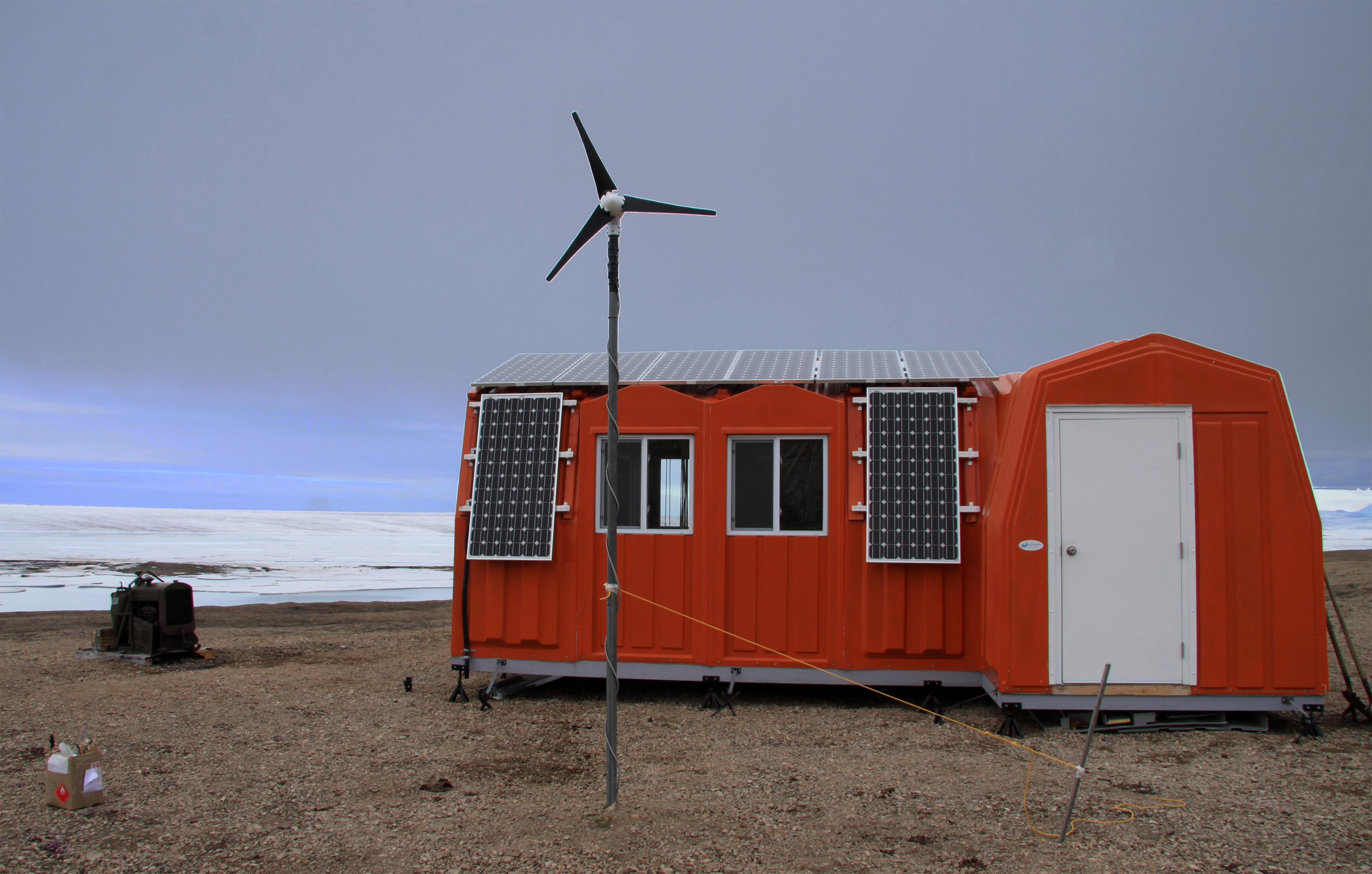
The first known sighting was in 1876 by Pelham Aldrich, a lieutenant with the George Nares expedition, and named for George Ward Hunt, First Lord of the Admiralty (1874-1877). Ward Hunt Island was briefly used as a weather station during the International Geophysical Year of 1957-58, and since then it has been used as the starting point for a number of attempts to reach the North Pole, beginning with Ralph Plaisted in 1968. Scientists have been working at the station since the 1950s. Parks Canada has three Weatherhaven shelters with oil burner furnaces, each can host 12 people for sleeping. CEN operates three automated, year-round climate stations of SILA Network in the region. A laboratory made of insulated fiberglass and powered by solar panels was built in 2010 thanks to a federal infrastructure grant.

General research and databases

Main research fields comprise the structure and functioning of lake and river ecosystems at high latitudes, dynamics of northern ice shelves, microbial ecology, geomorphology of polar desert landscapes, impacts of UV radiation, and Climate Change on aquatic ecosystems. Extensive climate data records are available on the Nordicana D: www.cen.ulaval.ca/nordicanad/. For requests concerning ecological monitoring data, please contact the leading researcher, Warwick Vincent (warwick.vincent@bio.ulaval.ca).

Station Monitoring

Human dimension

No communities live on Ward Hunt Island. The nearest community is Grise Fjord, located 800 km away on southern Ellesmere Island. Grise Fjord, (Inuktitut: Aujuittuq, &ldquo;place that never thaws&rdquo;; Inuktitut syllabics: ) is a small Inuit hamlet in the Qikiqtaaluk Region in the territory of Nunavut, Canada. With a population of 141 residents (as of the Canada 2006 Census), it is the only Inuit community on Ellesmere Island. It is also one of the coldest inhabited places in the world, with an average yearly temperature of -16.5&deg;C. Grise Fjord lies 1160 km north of the Arctic Circle in the Arctic Cordillera mountain range which is the only major mountain system east of the Canadian Rockies. The Canadian military base Alert is 170 km to the East and slightly to the South of Ward Hunt Island.

Access

Given that this is an extremely isolated station in a national park, all research activities must be planned and proposed at least one year in advance. Contact CEN for more information (cen@cen.ulaval.ca). For information on access and permits, contact Quttinirpaaq Park Manager (www.pc.gc.ca/pn-np/nu/quttinirpaaq/plan.aspx) and the Polar Continental Shelf Project (PCSP) for appropriate application forms to access the site via chartered flights (http://polar.nrcan.gc.ca/).

Member of: