Address

Department of Environment,
Government of Nunavut,
Po Box 209, Igloolik,
NU, X0A 0L0 Canada

Station manager

Lynda orman
E-mail: lorman@gov.nu.ca

Station Features

Opening year: 1975 Status: Open
  • Type of station: Station
  • Operational period – year-round or Month A to Month B: Year-round
  • Name of station owner: Government of Nunavut
  • Type of owner: Government
  • Name of managing institution: Department of Environment, Government of Nunavut
  • Managing Institution Country: Canada
  • Station owner country: Canada
  • Partner institution: No
  • Station latitude: 69,37608056
  • Station longitude: -81,80315278
  • Country (station location): Canada
  • Altitude of station: 23 m a.s.l
  • Min. altitude within study area: 0 m a.s.l
  • Max. altitude within study area: 23 m a.s.l
  • Nearest town/settlement: Igloolik
  • Distance to nearest town/settlement: 0 km
  • Number of residents in nearest town: 1600
  • Distance to nearest research station: 425 km
  • Maps available at station: Map (1:250 000), aerial image, satellite image, Google Earth with high resolution
  • Climate zone: High Arctic
  • Period of measurments for climate data below [year to year]:
  • Mean annual temperature: -13,6 °C
  • Mean temperature in February: -31,2 °C
  • Mean temperature in July: 7 °C
  • Precipitation type: Snow, Rain
  • Sea ice break up: September
  • Lake ice break up: July
  • Dominant wind direction: North
  • Mean annual wind speed: 0 m/s
  • Maximum wind speed (absolute): 0 m/s
  • Landscape features Lake, Sea
  • Permafrost zone Continuous

Facilities

  • Area under roof: 100 m²
  • Max. number of visitors at a time : 12
  • Showers: Yes
  • Laundry facilities: No
  • Power supply – period (from ‘hour’ to ‘hour’ or 24 hours): 24 hours
  • Workshops Metal, Plexiglas, Wood
  • Air transport landing facilities at station Airstrip
  • Airstrip (Length × Width) : 1360 × 40 m (commercial airport and lake)
  • Airstrip surface : Gravel/Sand
  • Transport on land - at station ATV, Snowmobile, Car
  • Transport on water - at station Open boat/Dhinghy
  • Number of staff peak season/summer: 15
  • Number of staff off season/winter: 12
  • Staff able to assist (workshops): Yes - if time allows
  • Compulsory safety equipment PLB, VHF, Weapon/rifle
  • Field to station Mobile phone, VHF, Satellite phone
  • Station to outside world Mobile phone, Internet
  • IT Infrastructure Wifi, Computers, Printer
  • Medical capability Basic
  • Staff with medical training/doctor When open
  • Distance to hospital (estimated time – hours): 1000

Science

  • Transnational Access: No
  • Remote Access: No
  • INTERACT Virtual Access: No
  • Permitting issues categories
    • Permits required for access to the station
    • Permits required for studies
  • Partner institutions (involved in the operation of the station)
    • Partner institution
  • Climate
    • Snow
    • Rain
    • Hail
  • Housing and accomodation
    • Showers
    • Laundry facilities
    • A
    • B
    • C
    • D
    • E
    • F
    • G
    • H
    • I
    • J
    • K
    • L
    • M
    • N
    • O
    • Municipal grid
    • Diesel/oil/gas
    • Wood
    • Solar
    • Wind
    • Water
    • Geothermal
    • Biofuel
    • Other
  • Logistics
    • Electrical and IT technologies
    • Mechanical
    • Metal
    • Wood
    • Plexiglas
    • Other
    • Walk
    • None
    • Tracked vehicle
    • Truck
    • SUV (4x4)
    • Car
    • ATV
    • Zodiac
    • Snowmobile
    • Open boat/Dhinghy
    • Closed boat
    • Bicycles
    • Amphibie vehicle
    • Ski
    • Other
    • Snow shoes
    • KickSledges
    • Other
    • Ski
    • Snowmobile
    • Boat
    • Car
    • Tracked vehicle
    • Truck
    • SUV (4x4)
    • Bus
    • Train
    • Airstrip
    • Scheduled flight
    • Chartered plane/helicopter
    • Helipad
    • Other
    • None
    • Harbour/port
    • Warf/pier
    • Pontoon/float bridge
    • Barges
    • Beach
  • Aircraft landing facilities
    • Helipad
  • Features in the facility area
    • Permanent snowpatches
    • Mountain
    • Valley
    • Lake
    • River
    • Shoreline
    • Tree line
    • Polar deserts/semi-deserts
    • Shrub tundra
    • Gramminoid tundra
    • Forest tundra
    • Peatlands
    • Wetlands
    • Palsa mires
    • Deciduous forest
    • Evergreen forest
    • Human settlements or resource use in the area
    • Arable land
    • Other
  • Main science disciplines
    • Astronomy
    • Atmospheric sciences
    • Cryology
    • Geology
    • Hydrology
    • Limnic biology
    • Marine biology
    • Terrestrial biology
    • Human biology
    • Anthropology
    • Archaeology
    • Sociology
    • Climate change
    • Environmental science (incl. pollution)
    • Oceanography
    • Agriculture
    • Animal husbandry
    • Fisheries
    • Forestry
    • Hunting
    • Tourism
  • Workshop facilities
    • Metal workshop
    • Wood workshop
    • Plexiglas workshop
    • Staff available to assist with constructions
  • Communication
    • Telephone
    • Satellite phone
    • VHF
    • E-mail
    • Internet
    • Computer
    • Printer
    • Scanner
    • Fax
  • Landscape and environment
    • Mountains
    • Nunataks
    • Volcano/crater
    • Lava fields
    • Plateaus
    • Moraines
    • Valleys
    • Homothermic Springs
    • Lake
    • Thermokarst lake
    • River
    • Delta/estuarie
    • Fjord
    • Sea
    • Continuous
    • Discontinuous
    • Beach
    • Sporadic
    • Rocky shores
    • Pingos/ice lenses
    • Sea cliffs
    • Other (text)
    • Palsa mires
    • None
    • Ice Caps
    • Glaciers
    • Permanent snow patches
    • None
    • Tree line
    • Polar desert/Semi-desert
    • Gramminoid tundra
    • Shrub tundra
    • Forest tundra
    • Wetlands
    • Peatlands/mires
    • Salt marshes/lagoons
    • Heath
    • Grassland
    • Deciduous forest
    • Evergreen forest
    • Terrestrial carnivores
    • Alpine heath
    • Ungulates
    • Hares
    • Other (text)
    • Rodents
    • Bird colonies
    • Polar bear
    • Whales
    • Seals
    • Fish
    • Settlement
    • Fishing
    • Hunting
    • Forestry
    • Agriculture
    • Tourism
    • Animal husbandry
    • Leisure activities
  • Field equipment
    • PLB
    • VHF
    • HF
    • Satellite phone
    • Mobile phone
    • GPS
    • Weapon/rifle
    • Flare gun
    • Bearspray
    • PLB
    • First aid kit
    • Glacier rescue kit
    • VHF
    • Avalanche rescue kit
    • HF
    • Satellite phone
    • Overnight equipment
    • Other
    • Mobile phone
    • GPS
    • Weapon/rifle
    • Flare gun
    • Bearspray
    • PLB
    • First aid kit
    • Glacier rescue kit
    • VHF
    • Avalanche rescue kit
    • HF
    • Satellite phone
    • Overnight equipment
    • Other
    • Mobile phone
    • GPS
    • Weapon/rifle
    • Flare gun
    • Bearspray
    • Tent
    • First aid kit
    • Glacier rescue kit
    • Sleeping matress
    • Avalanche rescue kit
    • Sleeping bag
    • Cooking equipment and utensils
    • Overnight equipment
    • Other
    • Gas/alcohol for cooking
    • Field power supply available at station
  • Communication and IT
    • Mobile phone
    • VHF
    • Satellite phone
    • Other
    • Satellite phone
    • Mobile phone
    • Internet
    • Other
    • Wireless transfer of data from field site to station
    • Wifi
    • Computers
    • Printer
    • Data storage
    • Statistical tools
    • GIS tools
    • Other
  • Medical facilities
    • Medical facilities
    • Basic
    • Medium
    • Extensive
    • Dental
    • Surgery
    • Other
    • No
    • In peak season
    • When open

Station name and owner

The Igloolik Research Center is owned by the Department of Environment of the Government of Nunavut, CANADA.

Location

The Igloolik Research Center (IRC) with its main building with offices and laboratories, as well as warm and cold warehouses is located in the hamlet of Igloolik, Nunavut, Canada (69°22’ N, 81°48’W). The center is located on a small island at the northern tip of the Foxe Basin, in between the continent and the large Baffin Island. Additional facilities include stations in Kugluktuk (67°49’ N, 115°06’ W), Arviat (61°06’ N, 94°03’ W), Pond Inlet (72°41’ N, 77°57’ W), and Iqaluit (63°44’ N, 68°31’ W).

Climate data

Grey colours are WMO Climate Normals including maximum and minimum values. Blue colours are individual years.

Climate data for the stations where extracted via Copernicus Climate Data Store, from the global gridded reanalysis product: ERA5 monthly averaged data on single levels from 1940 to present. Description and source code: Roemer J.K. 2023. https://doi.org/10.5281/zenodo.10214922 Data Source: Hersbach et al. 2023. Copernicus Climate Change Service (C3S) Climate Data Store (CDS), https://doi.org/10.24381/cds.f17050d7

Biodiversity and natural environment

Igloolik is located in the tundra zone and is part of the northern arctic ecozone. Snow cover usually remains from September to June. Extremely low temperatures are common (-30°C as a mean temperature during winter month). The average precipitation per year is c. 280 mm. Much of the landscape is composed of barren plains covered by frost-patterned soils and rock outcrop. This area is rich in sea mammals and seabirds, with charismatic polar bears, belugas, and killer whales. The terrestrial wildlife includes in particular caribou (although declining in abundance), Arctic foxes, several waterfowl species, snow geese, falcons, and lemmings.

History and facilities

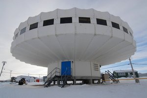
The facility was established by the federal government of Canada in the early 1970s to strengthen research in the Eastern Canadian Arctic. Within the main building, eight offices and two labs lead radially from a central area used for meetings. The research centre supplies local transportation with trucks, snowmobiles, sledges, boats with outboard motors, and ATVs all stored in a warm and a cold warehouse. Biologists, social scientists, and technicians of the Department of Environment, conduct research on a variety of terrestrial wildlife and management issues.

General research and databases

Research focuses on terrestrial wildlife and habitats with a special mandate on species directly linked to the traditional life of Inuit, i.e. caribou, polar bears, and muskoxen. The main research objectives of the station are to provide up-to-date information from various sources, including in-house scientific research and Inuit Qaujimajatuqangit, to co-management partners in order to make responsible wildlife management and land use decisions. Existing data bases include reports and publications arising from research at the station, climate records, terrestrial wildife survey and trends, as well as habitat mapping, wildlife monitoring, and ecosystem modelling.

Station Monitoring

Human dimension

Nunavut is the newest territory in Canada and is one of the most remote and sparsely populated regions in the world. It covers a large area of c. 2 millions km2. The Igloolik hamlet is located almost centrally in Nunavut and harbores approximately 1600 inhabitants (1/20 of the total population in Nunavut). The traditional Inuit culture still plays a major role in the daily life. Fishing and hunting is very important to local residents, all year round, focusing in particular on caribous, polar bears, seals, and beluga whales.

Access

During the summer, there are commercial plane and boat services available to reach the station. Regular flights are available from Iqaluit (Nunavut capital), which is connected every day to Montreal and Ottawa. For local transportation the center offers logistical support to researchers working on site and in the larger area. This includes snowmobiles, a 4×4 truck, ATVs, and boats.

Member of: