Address

CEN Salluit Research Station
467 Aqqutiqutaak St.
Salluit, Qc J0M 1S0

Station manager

Mickaél Lemay
E-mail: mickael.lemay@cen.ulaval.ca

Contact Station

Phone: +1 (418) 656-2746
E-mail: cen@cen.ulaval.ca

www.cen.ulaval.ca/en/page.aspx?lien=stationsalluit

Station Features

Opening year: 2011 Status: Open
  • Type of station: Station
  • Operational period – year-round or Month A to Month B: Year-round
  • Name of station owner: CEN/Université Laval in collaboration with the village of Salluit
  • Type of owner: Government
  • Name of managing institution: CEN/Université Laval
  • Managing Institution Country: Canada
  • Station owner country: Canada
  • Partner institution: No
  • Station latitude: 62,20320556
  • Station longitude: -75,63962222
  • Country (station location): Canada
  • Altitude of station: 35 m a.s.l
  • Min. altitude within study area: 0 m a.s.l
  • Max. altitude within study area: 160 m a.s.l
  • Nearest town/settlement: Salluit village
  • Distance to nearest town/settlement: 0 km
  • Number of residents in nearest town: 1350
  • Distance to nearest research station: 400 km
  • Maps available at station: Aerial image, Google Earth
  • Climate zone: Low Arctic
  • Period of measurments for climate data below [year to year]: Since 1997
  • Mean annual temperature: -8,5 °C
  • Mean temperature in February: -25,2 °C
  • Mean temperature in July: 7,1 °C
  • Precipitation type: Snow, Rain, Hail
  • Sea ice break up: June, July
  • Dominant wind direction: South
  • Mean annual wind speed: 6 m/s
  • Maximum wind speed (absolute): 34 m/s
  • Landscape features Mountains, Valleys, Lake, River, Sea
  • Permafrost zone Continuous
  • Vegetation zone Shrub tundra, Wetlands
  • Human use Settlement

Facilities

  • Area under roof: 50 m²
  • Max. number of visitors at a time : 6
  • Showers: Yes
  • Laundry facilities: Yes
  • Power supply – period (from ‘hour’ to ‘hour’ or 24 hours): 24 hours
  • Power supply - plug type A, B
  • Power sources at station Other
  • Logistics area: 0 m²
  • Workshops Metal, Plexiglas, Wood
  • Air transport landing facilities at station Airstrip
  • Airstrip (Length × Width) : 1174 × 30 m (lake: yes)
  • Airstrip surface : Gravel/Sand
  • Transport on land - at station ATV, Snowmobile, Car
  • Number of staff peak season/summer: 0
  • Number of staff off season/winter: 0
  • Compulsory safety equipment Satellite phone
  • Recommended safety equipment Weapon/rifle
  • Laboratory area: 0 m²
  • Field to station Mobile phone, VHF, Satellite phone
  • Station to outside world Mobile phone, Internet, Other
  • IT Infrastructure Wifi, Printer
  • Medical facilities: Yes
  • Medical capability Basic
  • Staff with medical training/doctor No
  • Distance to hospital (estimated time – hours): 0

Science

  • Transnational Access: No
  • Remote Access: No
  • INTERACT Virtual Access: No
  • Permitting issues categories
    • Permits required for access to the station
    • Permits required for studies
  • Partner institutions (involved in the operation of the station)
    • Partner institution
  • Climate
    • Snow
    • Rain
    • Hail
  • Housing and accomodation
    • Showers
    • Laundry facilities
    • A
    • B
    • C
    • D
    • E
    • F
    • G
    • H
    • I
    • J
    • K
    • L
    • M
    • N
    • O
    • Municipal grid
    • Diesel/oil/gas
    • Wood
    • Solar
    • Wind
    • Water
    • Geothermal
    • Biofuel
    • Other
  • Logistics
    • Electrical and IT technologies
    • Mechanical
    • Metal
    • Wood
    • Plexiglas
    • Other
    • Walk
    • None
    • Tracked vehicle
    • Truck
    • SUV (4x4)
    • Car
    • ATV
    • Zodiac
    • Snowmobile
    • Open boat/Dhinghy
    • Closed boat
    • Bicycles
    • Amphibie vehicle
    • Ski
    • Other
    • Snow shoes
    • KickSledges
    • Other
    • Ski
    • Snowmobile
    • Boat
    • Car
    • Tracked vehicle
    • Truck
    • SUV (4x4)
    • Bus
    • Train
    • Airstrip
    • Scheduled flight
    • Chartered plane/helicopter
    • Helipad
    • Other
    • None
    • Harbour/port
    • Warf/pier
    • Pontoon/float bridge
    • Barges
    • Beach
  • Aircraft landing facilities
    • Helipad
  • Features in the facility area
    • Permanent snowpatches
    • Mountain
    • Valley
    • Lake
    • River
    • Shoreline
    • Tree line
    • Polar deserts/semi-deserts
    • Shrub tundra
    • Gramminoid tundra
    • Forest tundra
    • Peatlands
    • Wetlands
    • Palsa mires
    • Deciduous forest
    • Evergreen forest
    • Human settlements or resource use in the area
    • Arable land
    • Other
  • Main science disciplines
    • Astronomy
    • Atmospheric sciences
    • Cryology
    • Geology
    • Hydrology
    • Limnic biology
    • Marine biology
    • Terrestrial biology
    • Human biology
    • Anthropology
    • Archaeology
    • Sociology
    • Climate change
    • Environmental science (incl. pollution)
    • Oceanography
    • Agriculture
    • Animal husbandry
    • Fisheries
    • Forestry
    • Hunting
    • Tourism
  • Workshop facilities
    • Metal workshop
    • Wood workshop
    • Plexiglas workshop
    • Staff available to assist with constructions
  • Communication
    • Telephone
    • Satellite phone
    • VHF
    • E-mail
    • Internet
    • Computer
    • Printer
    • Scanner
    • Fax
  • Sub-surface characteristics
    • Ground surface temperature
    • Soil temperature
    • Soil moisture
    • Ground water table
    • Soil water chemistry
    • Active layer depth
    • Permafrost distribution
    • Permafrost thickness
    • Permafrost temperature
  • Snow characteristics
    • Snow depth
    • Snow cover
    • Snow density
    • Snow temperature
  • Meteorology
    • Air temperature
    • Air humidity
    • Air pressure
    • Wind velocity
    • Wind direction
    • Precipitation
  • Vegetation
    • Flowering phenology
    • Amount of flowering
    • NDVI (plot/transect)
    • Landscape NDVI (from satellite images)
    • Vascular plant community composition
    • Bryophyte community composition
    • Lichen community composition
    • Fungi community composition
    • Berry production
    • Aerobiological monitoring (pollen, spores, etc.)
    • Species list (community composition)
  • Hydrology/Limnology
    • River water discharge/water level
    • Lake water level
    • Water balance
    • Water temperature
    • Lake ice cover (formation/breakup/thickness)
    • Suspended sediment discharge
    • Organic matter discharge
    • PAR (Photosyntetically Active Radiation)/secchi depth
    • Water chemistry
  • Parasites
    • Mammals
    • Birds
    • Fish
    • Vegetation
    • Other
  • Mammals
    • Mammal abundance
    • Mammal distribution
    • Mammal reproduction
    • Mortality
    • Predation
    • Physiology
    • Species list (community composition)
  • Landscape and environment
    • Mountains
    • Nunataks
    • Volcano/crater
    • Lava fields
    • Plateaus
    • Moraines
    • Valleys
    • Homothermic Springs
    • Lake
    • Thermokarst lake
    • River
    • Delta/estuarie
    • Fjord
    • Sea
    • Continuous
    • Discontinuous
    • Beach
    • Sporadic
    • Rocky shores
    • Pingos/ice lenses
    • Sea cliffs
    • Other (text)
    • Palsa mires
    • None
    • Ice Caps
    • Glaciers
    • Permanent snow patches
    • None
    • Tree line
    • Polar desert/Semi-desert
    • Gramminoid tundra
    • Shrub tundra
    • Forest tundra
    • Wetlands
    • Peatlands/mires
    • Salt marshes/lagoons
    • Heath
    • Grassland
    • Deciduous forest
    • Evergreen forest
    • Terrestrial carnivores
    • Alpine heath
    • Ungulates
    • Hares
    • Other (text)
    • Rodents
    • Bird colonies
    • Polar bear
    • Whales
    • Seals
    • Fish
    • Settlement
    • Fishing
    • Hunting
    • Forestry
    • Agriculture
    • Tourism
    • Animal husbandry
    • Leisure activities
  • Field equipment
    • PLB
    • VHF
    • HF
    • Satellite phone
    • Mobile phone
    • GPS
    • Weapon/rifle
    • Flare gun
    • Bearspray
    • PLB
    • First aid kit
    • Glacier rescue kit
    • VHF
    • Avalanche rescue kit
    • HF
    • Satellite phone
    • Overnight equipment
    • Other
    • Mobile phone
    • GPS
    • Weapon/rifle
    • Flare gun
    • Bearspray
    • PLB
    • First aid kit
    • Glacier rescue kit
    • VHF
    • Avalanche rescue kit
    • HF
    • Satellite phone
    • Overnight equipment
    • Other
    • Mobile phone
    • GPS
    • Weapon/rifle
    • Flare gun
    • Bearspray
    • Tent
    • First aid kit
    • Glacier rescue kit
    • Sleeping matress
    • Avalanche rescue kit
    • Sleeping bag
    • Cooking equipment and utensils
    • Overnight equipment
    • Other
    • Gas/alcohol for cooking
    • Field power supply available at station
  • Laboratory
    • Freezer < -80
    • Freezer -40 - -10
    • Fridge
    • Microscopes
    • Basic laboratory equipment
    • Advanced laboratory equipment
    • Basic chemical reagents
    • Analytical instrumentation
    • Other
    • Laboratory available in nearby town/settlement
  • Communication and IT
    • Mobile phone
    • VHF
    • Satellite phone
    • Other
    • Satellite phone
    • Mobile phone
    • Internet
    • Other
    • Wireless transfer of data from field site to station
    • Wifi
    • Computers
    • Printer
    • Data storage
    • Statistical tools
    • GIS tools
    • Other
  • Medical facilities
    • Medical facilities
    • Basic
    • Medium
    • Extensive
    • Dental
    • Surgery
    • Other
    • No
    • In peak season
    • When open

Station name and owner

CEN Salluit Research Station is owned and run by Centre d'etudes Nordiques (CEN: Centre for Northern Studies) whose secretariat is based at Université Laval, Québec, Canada.

Location

The station is situated in the Inuit community of Salluit, Nunavik, Québec, Canada (62°12'N, 75°38' W).

Climate data

Grey colours are WMO Climate Normals including maximum and minimum values. Blue colours are individual years.

Climate data for the stations where extracted via Copernicus Climate Data Store, from the global gridded reanalysis product: ERA5 monthly averaged data on single levels from 1940 to present. Description and source code: Roemer J.K. 2023. https://doi.org/10.5281/zenodo.10214922 Data Source: Hersbach et al. 2023. Copernicus Climate Change Service (C3S) Climate Data Store (CDS), https://doi.org/10.24381/cds.f17050d7

Biodiversity and natural environment

Salluit is located in the low arctic tundra in the continuous permafrost zone. The hilly bedrock consists principally of gneissic rocks from the Precambrian belonging to the Canadian Shield. The village is located in a valley that opens to the shore of Sugluk inlet (a fjord). The surrounding landscape consists of rocky plateaus with a hilly topography. The region was deglaciated about 8000 years ago and sectors below the elevation of 150 m were inundated by the post-glacial d&rsquo;Iberville Sea. Till and some glacio-fluvial sediments are the major surficial materials on the plateaus, while the Salluit valley and the other valleys that connect with the fjord (particularly at the fjord head) are floored with fluvial sediments in terraces and marine clay. The geology and the oceanography of the fjord are poorly studied. The fjord opens to Hudson Strait. Mean annual air temperature is c. -8 &deg;C and annual precipitation c. 300 mm (50 % snow).

History and facilities

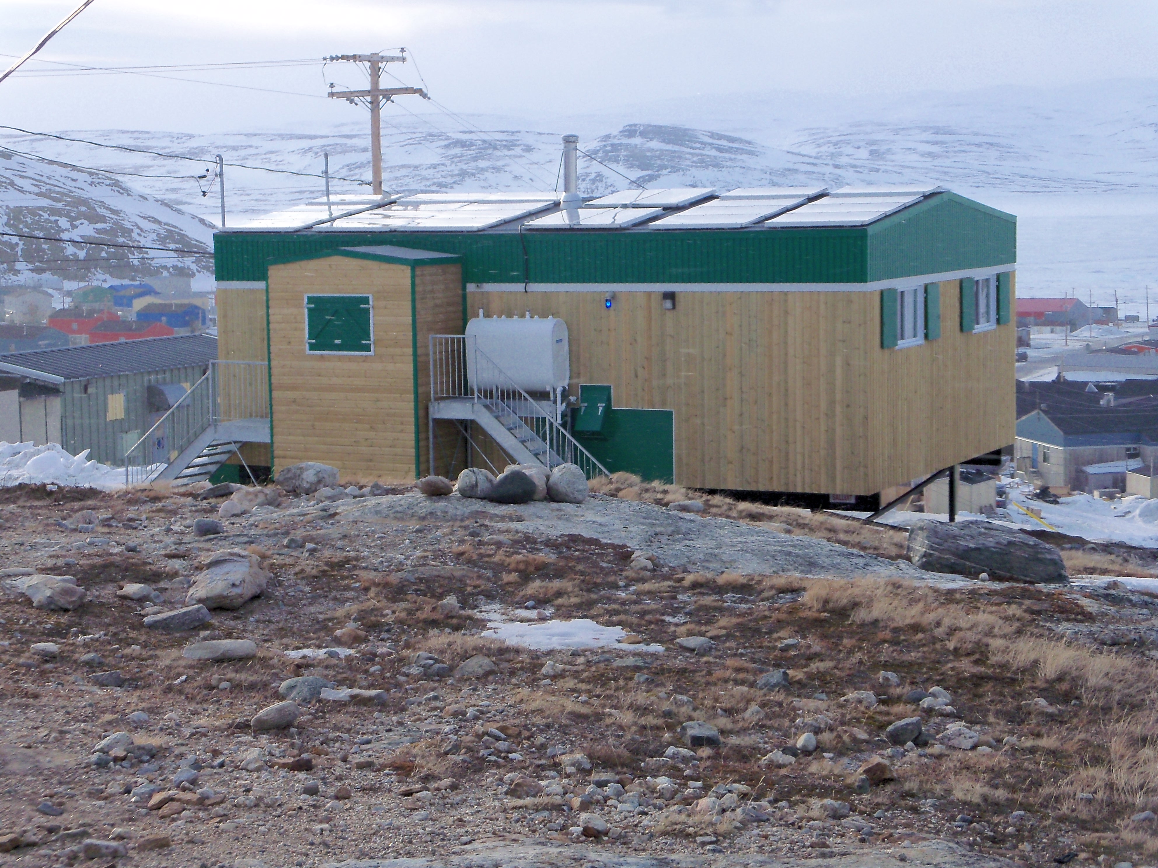
Research has been conducted in the region in both natural and human sciences since the early 1960s by various groups. Permafrost research by the CEN began in 1987. In the context of Climate Change, a major research program was undertaken in 2002 to support community adaptation to changing permafrost and to assist the community in addressing housing and infrastructure needs for the rapidly growing population. The field station (a house) was built in 2010 thanks to a grant acquired from a federal research infrastructure program.

General research and databases

Numerous theses and research papers have been published on permafrost, periglacial geomorphology (ice-wedges, slope processes), archaeology, climatology, paleo-climate (paleo-soils and lake cores), population, culture, and land management in the area. Climate and permafrost temperature data from automatic stations, in operation since August 2002, are available upon request at cen@cen.ulaval.ca. Data available through Nordicana&nbsp;D: www.cen.ulaval.ca/nordicanad/.

Station Monitoring

Human dimension

Inuit and their ancestors have occupied the region for over 3500 years. Many of the key archaeological sites of the Hudson Strait region are along the fjord coastline and along Hudson Strait. The shift from a nomadic lifestyle to permanent settlement led to the growth of the village in the 1930s with the installation of the Hudson Bay Company and churches. The population size has reached about 1350 inhabitants, with youths constituting an important part of the population.

Access

Access is by commercial airlines from Montr&eacute;al and Qu&eacute;bec city. Every summer, several cargo ships allow shipping of heavy equipment and materials, though this requires planning in advance. The station has no permanent staff. Local support for services and field work is available in the community. Station &shy;users are instructed to do their cleaning and take good care of the premises and do minimal maintenance, if needed. Contact CEN (station@cen.ulaval.ca) for more information.

Member of: