Address

Boniface River Camp
Centre d’études nordiques
C.P. 59
Kuujjuarapik-Whapmagoostui
Québec
Canada J0M 1G0

Station manager

Mickaél Lemay
E-mail: mickael.lemay@cen.ulaval.ca

Contact Station

Phone: +1 819-929-3319
E-mail: station@cen.ulaval.ca

http://www.cen.ulaval.ca/en/station.php?id=327&nm=boniface

Station Features

Opening year: 1988 Status: Open
  • Type of station: Station
  • Operational period – year-round or Month A to Month B: Year-round
  • Name of station owner: CEN/Université Laval
  • Type of owner: Government
  • Name of managing institution: CEN/Université Laval
  • Managing Institution Country: Canada
  • Station owner country: Canada
  • Partner institution: No
  • Station latitude: 57,74778056
  • Station longitude: -76,16263333
  • Country (station location): Canada
  • Altitude of station: 115 m a.s.l
  • Min. altitude within study area: 90 m a.s.l
  • Max. altitude within study area: 300 m a.s.l
  • Nearest town/settlement: Inukjuak
  • Distance to nearest town/settlement: 140 km
  • Number of residents in nearest town: 400
  • Distance to nearest research station: 115 km
  • Maps available at station: Aerial image, Google Earth
  • Climate zone: Sub-Arctic
  • Period of measurments for climate data below [year to year]: Since 1988
  • Mean annual temperature: -4 °C
  • Mean temperature in February: -24 °C
  • Mean temperature in July: 12,5 °C
  • Precipitation type: Snow
  • Sea ice break up: June, July
  • Dominant wind direction: South
  • Mean annual wind speed: 4 m/s
  • Maximum wind speed (absolute): 21 m/s
  • Landscape features Valleys, Lake, River, Sea
  • Permafrost zone Discontinuous
  • Snow and ice on land Glaciers
  • Vegetation zone Tree line, Shrub tundra, Forest tundra, Peatlands, Wetlands, Peatlands/mires

Facilities

  • Area under roof: 50 m²
  • Max. number of visitors at a time : 9
  • Showers: Yes
  • Laundry facilities: No
  • Power supply – period (from ‘hour’ to ‘hour’ or 24 hours): 24 hours
  • Power supply - plug type A, B
  • Power sources at station Diesel/oil/gas, Wind, Other
  • Logistics area: 25 m²
  • Means of transportation to/from station Chartered plane/helicopter
  • Air transport landing facilities at station Airstrip, Helipad
  • Airstrip (Length × Width) : 300 × 40 m (lake: yes)
  • Airstrip surface : Gravel/Sand
  • Transport on land - at station Snowmobile
  • Transport on water - at station Zodiac, Closed boat
  • Number of staff peak season/summer: 0
  • Number of staff off season/winter: 0
  • Compulsory safety equipment Satellite phone, Weapon/rifle
  • Recommended safety equipment Other
  • Laboratory area: 25 m²
  • Field to station VHF, Satellite phone
  • Station to outside world Other
  • Distance to hospital (estimated time – hours): 260

Science

  • Arctic Council working groups
  • CAFF Circum Arctic Rangifer Monitoring and Assessment Network (Arctic), https://carma.caff.is/
  • Transnational Access: No
  • Remote Access: No
  • INTERACT Virtual Access: No
  • Permitting issues categories
    • Permits required for access to the station
    • Permits required for studies
  • Partner institutions (involved in the operation of the station)
    • Partner institution
  • Climate
    • Snow
    • Rain
    • Hail
  • Housing and accomodation
    • Showers
    • Laundry facilities
    • A
    • B
    • C
    • D
    • E
    • F
    • G
    • H
    • I
    • J
    • K
    • L
    • M
    • N
    • O
    • Municipal grid
    • Diesel/oil/gas
    • Wood
    • Solar
    • Wind
    • Water
    • Geothermal
    • Biofuel
    • Other
  • Logistics
    • Electrical and IT technologies
    • Mechanical
    • Metal
    • Wood
    • Plexiglas
    • Other
    • Walk
    • None
    • Tracked vehicle
    • Truck
    • SUV (4x4)
    • Car
    • Zodiac
    • ATV
    • Snowmobile
    • Open boat/Dhinghy
    • Closed boat
    • Bicycles
    • Amphibie vehicle
    • Ski
    • Other
    • Snow shoes
    • KickSledges
    • Other
    • Ski
    • Snowmobile
    • Boat
    • Car
    • Tracked vehicle
    • Truck
    • SUV (4x4)
    • Bus
    • Train
    • Airstrip
    • Scheduled flight
    • Chartered plane/helicopter
    • Helipad
    • Other
    • None
    • Harbour/port
    • Warf/pier
    • Pontoon/float bridge
    • Barges
    • Beach
  • Aircraft landing facilities
    • Helipad
  • Features in the facility area
    • Permanent snowpatches
    • Mountain
    • Valley
    • Lake
    • River
    • Shoreline
    • Tree line
    • Polar deserts/semi-deserts
    • Shrub tundra
    • Gramminoid tundra
    • Forest tundra
    • Peatlands
    • Wetlands
    • Palsa mires
    • Deciduous forest
    • Evergreen forest
    • Human settlements or resource use in the area
    • Arable land
    • Other
  • Main science disciplines
    • Astronomy
    • Atmospheric sciences
    • Cryology
    • Geology
    • Hydrology
    • Limnic biology
    • Marine biology
    • Terrestrial biology
    • Human biology
    • Anthropology
    • Archaeology
    • Sociology
    • Climate change
    • Environmental science (incl. pollution)
    • Oceanography
    • Agriculture
    • Animal husbandry
    • Fisheries
    • Forestry
    • Hunting
    • Tourism
  • Workshop facilities
    • Metal workshop
    • Wood workshop
    • Plexiglas workshop
    • Staff available to assist with constructions
  • Communication
    • Telephone
    • Satellite phone
    • VHF
    • E-mail
    • Internet
    • Computer
    • Printer
    • Scanner
    • Fax
  • Meteorology
    • Air temperature
    • Air humidity
    • Air pressure
    • Wind velocity
    • Wind direction
    • Precipitation
  • Vegetation
    • Flowering phenology
    • Amount of flowering
    • NDVI (plot/transect)
    • Landscape NDVI (from satellite images)
    • Vascular plant community composition
    • Bryophyte community composition
    • Lichen community composition
    • Fungi community composition
    • Berry production
    • Aerobiological monitoring (pollen, spores, etc.)
    • Species list (community composition)
  • Sub-surface characteristics
    • Ground surface temperature
    • Soil temperature
    • Soil moisture
    • Ground water table
    • Soil water chemistry
    • Active layer depth
    • Permafrost distribution
    • Permafrost thickness
    • Permafrost temperature
  • Snow characteristics
    • Snow depth
    • Snow cover
    • Snow density
    • Snow temperature
  • Landscape and environment
    • Mountains
    • Nunataks
    • Volcano/crater
    • Lava fields
    • Plateaus
    • Moraines
    • Valleys
    • Homothermic Springs
    • Lake
    • Thermokarst lake
    • River
    • Delta/estuarie
    • Fjord
    • Sea
    • Continuous
    • Discontinuous
    • Beach
    • Sporadic
    • Rocky shores
    • Pingos/ice lenses
    • Sea cliffs
    • Other (text)
    • Palsa mires
    • Ice Caps
    • None
    • Glaciers
    • Permanent snow patches
    • None
    • Tree line
    • Polar desert/Semi-desert
    • Gramminoid tundra
    • Shrub tundra
    • Forest tundra
    • Wetlands
    • Peatlands/mires
    • Salt marshes/lagoons
    • Heath
    • Grassland
    • Deciduous forest
    • Evergreen forest
    • Terrestrial carnivores
    • Alpine heath
    • Ungulates
    • Hares
    • Other (text)
    • Rodents
    • Bird colonies
    • Polar bear
    • Whales
    • Seals
    • Fish
    • Settlement
    • Fishing
    • Hunting
    • Forestry
    • Agriculture
    • Tourism
    • Animal husbandry
    • Leisure activities
  • Field equipment
    • PLB
    • VHF
    • HF
    • Satellite phone
    • Mobile phone
    • GPS
    • Weapon/rifle
    • Flare gun
    • Bearspray
    • PLB
    • First aid kit
    • Glacier rescue kit
    • VHF
    • Avalanche rescue kit
    • HF
    • Satellite phone
    • Overnight equipment
    • Other
    • Mobile phone
    • GPS
    • Weapon/rifle
    • Flare gun
    • Bearspray
    • PLB
    • First aid kit
    • Glacier rescue kit
    • VHF
    • Avalanche rescue kit
    • HF
    • Satellite phone
    • Overnight equipment
    • Other
    • Mobile phone
    • GPS
    • Weapon/rifle
    • Flare gun
    • Bearspray
    • Tent
    • First aid kit
    • Glacier rescue kit
    • Sleeping matress
    • Avalanche rescue kit
    • Sleeping bag
    • Cooking equipment and utensils
    • Overnight equipment
    • Other
    • Gas/alcohol for cooking
    • Field power supply available at station
  • Laboratory
    • Freezer < -80
    • Freezer -40 - -10
    • Fridge
    • Microscopes
    • Basic laboratory equipment
    • Advanced laboratory equipment
    • Basic chemical reagents
    • Analytical instrumentation
    • Other
    • Laboratory available in nearby town/settlement
  • Communication and IT
    • Mobile phone
    • VHF
    • Satellite phone
    • Other
    • Satellite phone
    • Mobile phone
    • Internet
    • Other
    • Wireless transfer of data from field site to station
    • Wifi
    • Computers
    • Printer
    • Data storage
    • Statistical tools
    • GIS tools
    • Other
  • Medical facilities
    • Medical facilities
    • Basic
    • Medium
    • Extensive
    • Dental
    • Surgery
    • Other
    • No
    • In peak season
    • When open

Station name and owner

The CEN Boniface River Field Station is owned and run by the Centre d'études Nordiques (CEN: Centre for Northern Studies) whose secretariat is based at Université Laval, Québec, Canada. This station is part of the CEN Network.

Location

The CEN Boniface River Field Station is situated within the forest tundra less than 10 km from the tree limit and some 50 km inland from Hudson Bay (57°45'N, 76°10'W).

Climate data

Grey colours are WMO Climate Normals including maximum and minimum values. Blue colours are individual years.

Climate data for the stations where extracted via Copernicus Climate Data Store, from the global gridded reanalysis product: ERA5 monthly averaged data on single levels from 1940 to present. Description and source code: Roemer J.K. 2023. https://doi.org/10.5281/zenodo.10214922 Data Source: Hersbach et al. 2023. Copernicus Climate Change Service (C3S) Climate Data Store (CDS), https://doi.org/10.24381/cds.f17050d7

Biodiversity and natural environment

The landscape around the station is composed of both wooded hills (30 %) and hills dominated by tundra vegetation (70 %). The most protected sites are generally forested except for areas that have been affected by fire and consequently induced an opening in the forest cover. Landscape features of scientific interest are discontinuous permafrost, thermokarst ponds, palsas, the Boniface River, and the treeline.

History and facilities

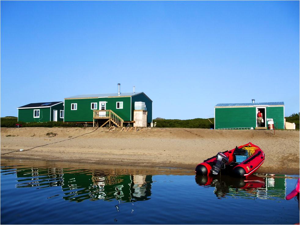
The CEN Boniface River Field Station was constructed in 1990 by Professor Serge Payette to conduct research on past treeline and tree growth dynamics in the context of Climate Change. It was upgraded in 2010. Presently, the station is comprised of three individual buildings (one with a shower) that serve primarily as laboratories and a kitchen building. These are powered by solar energy and heated with an oil furnace. Onsite there are two zodiac-style boats. Access to the different research sites is primarily by helicopter or by the Boniface River, which is navigable for some 20 km. Dormitory tents and sleeping bags for researchers and students can be provided by the CEN. Typically, between five and twenty people can be found at the research station during the summer season.

General research and databases

Meteorological stations installed within the proximity of the research station have been recording the prevailing conditions at the tree limit, including the thermal contrast (air and soil) between tundra and forest environments, since 1988. In addition, tree growth has been measured with the aid of a dozen electronic dendrometers since the summer of 2005. Data available through Nordicana D: www.cen.ulaval.ca/nordicanad/. Topics which are studied at the station include the following, but are not exclusive to these: Vegetation dynamics of a subarctic topo-sequence and the interaction between climate and forest fires, genetic homogeneity in the ecological heterogeneity of Qu&eacute;bec subarctic forests in relation to climatic change, black spruce growth as an indicator of Climate Change at the treeline in northern Quebec, origin and dynamics of wooded palsas in the Boniface River region, dwarf birch (Betula glandulosa) densification since 1950, the influence of permafrost on riverine ecosystem dynamics, fire history of the Boniface River region, long black spruce tree-ring chronology, riparian ecosystem dynamics, Holocene evolution of a palsa plateau at the tree limit, and structural dynamics of an ancient spruce lichen woodland at the northern forest limit.

Station Monitoring

Human dimension

No communities live at or near Boniface River Field Station. The nearest community is Inukjuak more than 140 km away and on the shores of eastern Hudson Bay.

Access

Beginning in the summer of 2001, supplies for the research station have been delivered primarily by fixed winged aircraft, i.e. Twin Otter, thanks to the construction of a 300 m long airstrip situated on the opposite shore of the research station. Access to the station is by chartered helicopter or Twin Otter, departing from Whapmagoostui-Kuujjuarapik. Contact CEN (cen@cen.ulaval.ca) for more information.

Member of: