Address

Whapmagoostui-Kuujjuarapik Research Station
Centre for Northern Studies (CEN)
C.P. 59 Kuujjuarapik
Québec, J0M 1G0
CANADA

Station manager

Mickaél Lemay
E-mail: mickael.lemay@cen.ulaval.ca

Contact Station

Phone: +1 819-929-3319
E-mail: station@cen.ulaval.ca

www.cen.ulaval.ca/en/page.aspx?lien=stationumiujaq

Station Features

Opening year: 2011 Status: Open
  • Type of station: Station
  • Operational period – year-round or Month A to Month B: Year-round
  • Name of station owner: CEN/Université Laval in collaboration with Makivik Corp. and the village of Umiujaq
  • Type of owner: Government
  • Name of managing institution: CEN/Université Laval
  • Managing Institution Country: Canada
  • Station owner country: Canada
  • Partner institution: Yes
  • Partner institution name: Makivik Corp. and the village of Umiujaq
  • Station latitude: 56,55194444
  • Station longitude: -76,54916667
  • Country (station location): Canada
  • Altitude of station: 5 m a.s.l
  • Min. altitude within study area: 0 m a.s.l
  • Max. altitude within study area: 400 m a.s.l
  • Nearest town/settlement: Umiujaq village
  • Distance to nearest town/settlement: 0 km
  • Number of residents in nearest town: 400
  • Distance to nearest research station: 125 km
  • Maps available at station: Aerial image, Google Earth
  • Climate zone: Sub-Arctic
  • Period of measurments for climate data below [year to year]: Since 1997
  • Mean annual temperature: -3 °C
  • Mean temperature in February: -22,4 °C
  • Mean temperature in July: 12,2 °C
  • Precipitation type: Snow, Rain, Hail
  • Sea ice break up: June, July
  • Dominant wind direction: South
  • Mean annual wind speed: 5,9 m/s
  • Maximum wind speed (absolute): 28,3 m/s
  • Landscape features Valleys, Lake, River, Delta/estuarie, Sea
  • Permafrost zone Discontinuous
  • Vegetation zone Tree line, Shrub tundra, Forest tundra, Peatlands, Wetlands, Peatlands/mires, Evergreen forest
  • Human use Settlement

Facilities

  • Area under roof: 50 m²
  • Max. number of visitors at a time : 6
  • Showers: Yes
  • Laundry facilities: Yes
  • Power supply – period (from ‘hour’ to ‘hour’ or 24 hours): 24 hours
  • Power supply - plug type A, B
  • Power sources at station Water, Other
  • Logistics area: 60 m²
  • Workshops Metal, Plexiglas, Wood
  • Air transport landing facilities at station Airstrip, Helipad
  • Airstrip (Length × Width) : 1174 × 30 (lake: yes)
  • Airstrip surface : Gravel/Sand
  • Transport on land - at station ATV, Snowmobile, Car
  • Transport on water - at station Open boat/Dhinghy
  • Water landing facilities Warf/pier
  • Number of staff peak season/summer: 0
  • Number of staff off season/winter: 0
  • Compulsory safety equipment Satellite phone, Other
  • Recommended safety equipment Weapon/rifle
  • Laboratory area: 100 m²
  • Field to station Mobile phone, VHF, Satellite phone
  • Station to outside world Mobile phone, Internet, Other
  • Medical facilities: Yes
  • Medical capability Basic
  • Distance to hospital (estimated time – hours): 0

Science

  • Transnational Access: No
  • Remote Access: No
  • INTERACT Virtual Access: No
  • Permitting issues categories
    • Permits required for access to the station
    • Permits required for studies
  • Partner institutions (involved in the operation of the station)
    • Partner institution
  • Climate
    • Snow
    • Rain
    • Hail
  • Housing and accomodation
    • Showers
    • Laundry facilities
    • A
    • B
    • C
    • D
    • E
    • F
    • G
    • H
    • I
    • J
    • K
    • L
    • M
    • N
    • O
    • Municipal grid
    • Diesel/oil/gas
    • Wood
    • Solar
    • Wind
    • Water
    • Geothermal
    • Biofuel
    • Other
  • Logistics
    • Electrical and IT technologies
    • Mechanical
    • Metal
    • Wood
    • Plexiglas
    • Other
    • Walk
    • None
    • Tracked vehicle
    • Truck
    • SUV (4x4)
    • Car
    • ATV
    • Zodiac
    • Snowmobile
    • Open boat/Dhinghy
    • Closed boat
    • Bicycles
    • Amphibie vehicle
    • Ski
    • Other
    • Snow shoes
    • KickSledges
    • Other
    • Ski
    • Snowmobile
    • Boat
    • Car
    • Tracked vehicle
    • Truck
    • SUV (4x4)
    • Bus
    • Train
    • Airstrip
    • Scheduled flight
    • Helipad
    • Chartered plane/helicopter
    • Other
    • None
    • Harbour/port
    • Warf/pier
    • Pontoon/float bridge
    • Barges
    • Beach
  • Aircraft landing facilities
    • Helipad
  • Features in the facility area
    • Permanent snowpatches
    • Mountain
    • Valley
    • Lake
    • River
    • Shoreline
    • Tree line
    • Polar deserts/semi-deserts
    • Shrub tundra
    • Gramminoid tundra
    • Forest tundra
    • Peatlands
    • Wetlands
    • Palsa mires
    • Deciduous forest
    • Evergreen forest
    • Human settlements or resource use in the area
    • Arable land
    • Other
  • Main science disciplines
    • Astronomy
    • Atmospheric sciences
    • Cryology
    • Geology
    • Hydrology
    • Limnic biology
    • Marine biology
    • Terrestrial biology
    • Human biology
    • Anthropology
    • Archaeology
    • Sociology
    • Climate change
    • Environmental science (incl. pollution)
    • Oceanography
    • Agriculture
    • Animal husbandry
    • Fisheries
    • Forestry
    • Hunting
    • Tourism
  • Workshop facilities
    • Metal workshop
    • Wood workshop
    • Plexiglas workshop
    • Staff available to assist with constructions
  • Communication
    • Telephone
    • Satellite phone
    • VHF
    • E-mail
    • Internet
    • Computer
    • Printer
    • Scanner
    • Fax
  • Meteorology
    • Air temperature
    • Air humidity
    • Air pressure
    • Wind velocity
    • Wind direction
    • Precipitation
  • Sub-surface characteristics
    • Ground surface temperature
    • Soil temperature
    • Soil moisture
    • Ground water table
    • Soil water chemistry
    • Active layer depth
    • Permafrost distribution
    • Permafrost thickness
    • Permafrost temperature
  • Snow characteristics
    • Snow depth
    • Snow cover
    • Snow density
    • Snow temperature
  • Geology/Geomorphology
    • Quaternary geology
    • Sedimentology
    • Bedrock geology
    • Erosion
  • Hydrology/Limnology
    • River water discharge/water level
    • Lake water level
    • Water balance
    • Water temperature
    • Lake ice cover (formation/breakup/thickness)
    • Suspended sediment discharge
    • Organic matter discharge
    • PAR (Photosyntetically Active Radiation)/secchi depth
    • Water chemistry
  • Vegetation
    • Flowering phenology
    • Amount of flowering
    • NDVI (plot/transect)
    • Landscape NDVI (from satellite images)
    • Vascular plant community composition
    • Bryophyte community composition
    • Lichen community composition
    • Fungi community composition
    • Berry production
    • Aerobiological monitoring (pollen, spores, etc.)
    • Species list (community composition)
  • Energy budget
    • Net radiation
    • Sensible heat flux
    • Latent heat flux
    • Soil heat flux
  • Lake ecology
    • Phytoplankton (including chlorophyll)
    • Zooplankton
    • Vegetation
    • Fish
    • Invertebrates
    • Species list (community composition)
  • Atmospheric composition
    • CO<sub>2</sub> concentration
    • CH<sub>4</sub> concentration
  • Landscape and environment
    • Mountains
    • Nunataks
    • Volcano/crater
    • Lava fields
    • Plateaus
    • Moraines
    • Valleys
    • Homothermic Springs
    • Lake
    • Thermokarst lake
    • River
    • Delta/estuarie
    • Fjord
    • Sea
    • Continuous
    • Discontinuous
    • Beach
    • Sporadic
    • Rocky shores
    • Pingos/ice lenses
    • Sea cliffs
    • Other (text)
    • Palsa mires
    • None
    • Ice Caps
    • Glaciers
    • Permanent snow patches
    • None
    • Tree line
    • Polar desert/Semi-desert
    • Gramminoid tundra
    • Shrub tundra
    • Forest tundra
    • Wetlands
    • Peatlands/mires
    • Salt marshes/lagoons
    • Heath
    • Grassland
    • Deciduous forest
    • Evergreen forest
    • Terrestrial carnivores
    • Alpine heath
    • Ungulates
    • Hares
    • Other (text)
    • Rodents
    • Bird colonies
    • Polar bear
    • Whales
    • Seals
    • Fish
    • Settlement
    • Fishing
    • Hunting
    • Forestry
    • Agriculture
    • Tourism
    • Animal husbandry
    • Leisure activities
  • Field equipment
    • PLB
    • VHF
    • HF
    • Satellite phone
    • Mobile phone
    • GPS
    • Weapon/rifle
    • Flare gun
    • Bearspray
    • PLB
    • First aid kit
    • Glacier rescue kit
    • VHF
    • Avalanche rescue kit
    • HF
    • Satellite phone
    • Overnight equipment
    • Other
    • Mobile phone
    • GPS
    • Weapon/rifle
    • Flare gun
    • Bearspray
    • PLB
    • First aid kit
    • Glacier rescue kit
    • VHF
    • Avalanche rescue kit
    • HF
    • Satellite phone
    • Overnight equipment
    • Other
    • Mobile phone
    • GPS
    • Weapon/rifle
    • Flare gun
    • Bearspray
    • Tent
    • First aid kit
    • Glacier rescue kit
    • Sleeping matress
    • Avalanche rescue kit
    • Sleeping bag
    • Cooking equipment and utensils
    • Overnight equipment
    • Other
    • Gas/alcohol for cooking
    • Field power supply available at station
  • Laboratory
    • Freezer < -80
    • Freezer -40 - -10
    • Fridge
    • Microscopes
    • Basic laboratory equipment
    • Advanced laboratory equipment
    • Basic chemical reagents
    • Analytical instrumentation
    • Other
    • Laboratory available in nearby town/settlement
  • Communication and IT
    • Mobile phone
    • VHF
    • Satellite phone
    • Other
    • Satellite phone
    • Mobile phone
    • Internet
    • Other
    • Wireless transfer of data from field site to station
    • Wifi
    • Computers
    • Printer
    • Data storage
    • Statistical tools
    • GIS tools
    • Other
  • Medical facilities
    • Medical facilities
    • Basic
    • Medium
    • Extensive
    • Dental
    • Surgery
    • Other
    • No
    • In peak season
    • When open

Station name and owner

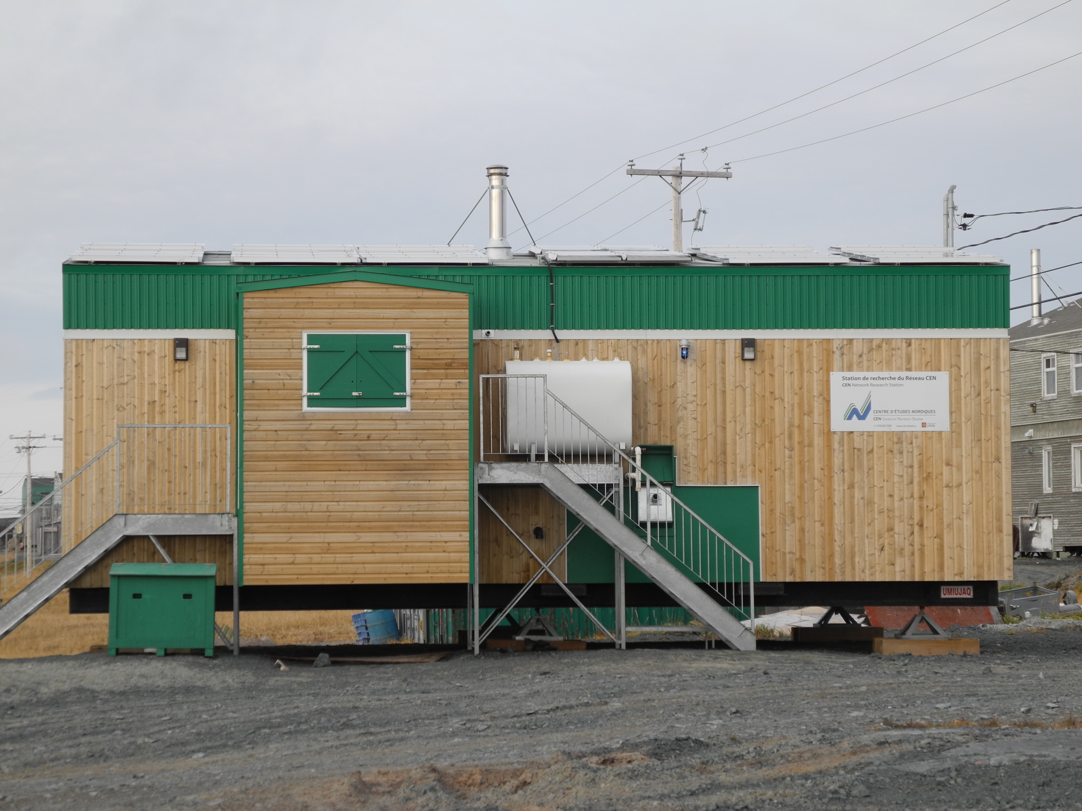
The Umiujaq Research Station is owned and run by the Centre d&rsquo;&eacute;tudes Nordiques (CEN: Centre for Northern Studies) whose secretariat is based at Universit&eacute; Laval, Qu&eacute;bec, Canada. This station is part of the CEN Network.

Location

The station is in the village of Umiujaq, situated on the shores of the eastern Hudson Bay in Nunavik, Qu&eacute;bec, Canada (56&deg;33&rsquo; N, 76&deg;32&rsquo; W).

Climate data

Grey colours are WMO Climate Normals including maximum and minimum values. Blue colours are individual years.

Climate data for the stations where extracted via Copernicus Climate Data Store, from the global gridded reanalysis product: ERA5 monthly averaged data on single levels from 1940 to present. Description and source code: Roemer J.K. 2023. https://doi.org/10.5281/zenodo.10214922 Data Source: Hersbach et al. 2023. Copernicus Climate Change Service (C3S) Climate Data Store (CDS), https://doi.org/10.24381/cds.f17050d7

Biodiversity and natural environment

The village is located 15 km north of Richmond Gulf (Lac Guillaume-Delisle), an immense inland bay connected to the Hudson Bay via a rocky gulch resembling a canyon. The many rivers flowing into the Gulf make its waters brackish and rich in brook trout, whitefish, seal, and beluga. The sheltered maritime environment features sporadic black spruce and larch, but the surrounding area is rather characterised by shrub tundra, discontinuous permafrost (mostly palsa bogs), and thermokarst lakes. In front of the village are the Nastapoka Islands (cuestas) where many species of birds, such as common loons, eider ducks, and peregrine falcons, find summer shelter and nest. The steep cliffs plunge into the Nastapoka Sound with waters up to 110 m deep. About 30&nbsp;km north of Umiujaq is the Nastapoka River with its scenic 30&nbsp;m high falls. The river estuary is extraordinarily rich and diverse with landlocked freshwater seals, salmon, and many fish species. Access to the Tursujuq Provincial Park, as well as to the marine/coastal-, river-, lake-, mountainous-, deltaic-, and shrub tundra environments, and the migrating treeline, is from Umiujaq.

History and facilities

Umiujaq was established in 1986 by Inuit from Kuujjuarapik, 160&nbsp;km to the south, who decided to relocate in the region where they hoped to better preserve their traditional lifestyle in an area where fish and game were not threatened by development. CEN&rsquo;s research has been conducted here since 1980. In previous years, CEN researchers used a meat plant/warehouse that has shared ownership (CEN, Anniturvik Landholding Corporation, and Makivik Corporation). In 2010, CEN undertook major station upgrades and restored the warehouse (still shared with its partners), built a vehicle garage, and a three-bedroom house. The facility is next to a pier for easy maritime access and can accommodate seven to eight people at a time. The house is equipped with partial solar powered electricity, running water (kitchen, toilet, and laundry), and oil heating.

General research and databases

Past and present research has focused on permafrost studies, coastal geology, and geomorphological characterisation of the region. Other research topics cover biodiversity and dynamics of northern aquatic ecosystems, impacts of thawing permafrost in the context of global warming, wetlands paleoecology, research on mercury dynamics (air, precipitation, snow), snow and ice dynamics, greenhouse gas emissions from thermokarst ponds and tundra, sea and lake bottom mapping, and plant community dynamics and response of northern plants to Climate Change. Archeological studies and community based monitoring activities have also taken place. CEN operates four climate stations in the area and thermistor cables are installed to monitor permafrost temperature. CEN has extensive climate data since 1997 which are available through Nordicana D: www.cen.ulaval.ca/nordicanad/.

Station Monitoring

Human dimension

Umiujaq has a population of about 500 inhabitants, mainly Inuit. The people speak Inuktitut and English with some French. Some research on the social dimensions has been conducted over time.

Access

Umiujaq is only accessible by commercial airlines. All research activities must be planned in advance. Maritime transport is available twice a year. Local guides and translators are available for hire. Access to the surrounding area by chartered flights (floatplane and helicopter) can be organized by CEN from the Whapmagoostui-Kuujjuarapik Research Station. Contact CEN (cen@cen.ulaval.ca) for more information.

Member of: