Address

CEN Radisson Ecological Research Station
30, 32, 34 and 36 Couture
Radisson, Quebec,
J0Y 2X0

Station manager

Mickaél Lemay
E-mail: mickael.lemay@cen.ulaval.ca

Contact Station

Phone: CEN Radisson Ecological Research Station
http://www.cen.ulaval.ca/en/station.php?id=320&nm=radisson
E-mail: station@cen.ulaval.ca

www.cen.ulaval.ca/en/page.aspx?lien=stationradisson

Station Features

Opening year: 1999 Status: Open
  • Type of station: Station
  • Operational period – year-round or Month A to Month B: Year-round
  • Name of station owner: CEN/Université Laval in collaboration with INRS, UQAR
  • Type of owner: Government
  • Name of managing institution: CEN/Université Laval
  • Managing Institution Country: Canada
  • Station owner country: Canada
  • Partner institution: Yes
  • Partner institution name: INRS and UQAR
  • Station latitude: 53,79333611
  • Station longitude: -77,60741111
  • Country (station location): Canada
  • Altitude of station: 135 m a.s.l
  • Min. altitude within study area: 0 m a.s.l
  • Max. altitude within study area: 135 m a.s.l
  • Nearest town/settlement: Radisson
  • Distance to nearest town/settlement: 0 km
  • Number of residents in nearest town: 300
  • Distance to nearest research station: 165 km
  • Maps available at station: Aerial image, Google Earth
  • Climate zone: Sub-Arctic
  • Period of measurments for climate data below [year to year]: Since 1995 (LaGrande)
  • Mean annual temperature: -3 °C
  • Mean temperature in February: -21,6 °C
  • Mean temperature in July: 13,7 °C
  • Precipitation type: Snow, Rain, Hail
  • Sea ice break up: June
  • River ice break up: June
  • Dominant wind direction: West
  • Mean annual wind speed: 4,5 m/s
  • Maximum wind speed (absolute): 37 m/s
  • Landscape features Valleys, Lake, River, Sea
  • Permafrost zone Sporadic
  • Vegetation zone Peatlands, Wetlands, Peatlands/mires, Evergreen forest

Facilities

  • Area under roof: 5860 m²
  • Max. number of visitors at a time : 28
  • Showers: Yes
  • Laundry facilities: Yes
  • Power supply – period (from ‘hour’ to ‘hour’ or 24 hours): 24 hours
  • Power supply - plug type A, B
  • Power sources at station Water, Other
  • Logistics area: 948 m²
  • Workshops Metal, Plexiglas, Wood
  • Means of transportation to/from station Car
  • Air transport landing facilities at station Airstrip, Helipad
  • Airstrip (Length × Width) : 1970 × 45 m (lake: yes)
  • Airstrip surface : Tarmac/Concrete
  • Transport on land - at station ATV, Snowmobile, Car
  • Transport on water - at station Zodiac, Open boat/Dhinghy, Other
  • Water landing facilities Warf/pier
  • Number of staff peak season/summer: 0
  • Number of staff off season/winter: 0
  • Recommended safety equipment Satellite phone, Weapon/rifle
  • Laboratory area: 1260 m²
  • Field to station Mobile phone, VHF, Satellite phone
  • Station to outside world Mobile phone, Internet, Other
  • IT Infrastructure Wifi, Computers, Printer
  • Medical facilities: Yes
  • Medical capability Basic

Science

  • Transnational Access: No
  • Remote Access: No
  • INTERACT Virtual Access: No
  • Permitting issues categories
    • Permits required for access to the station
    • Permits required for studies
  • Partner institutions (involved in the operation of the station)
    • Partner institution
  • Climate
    • Snow
    • Rain
    • Hail
  • Housing and accomodation
    • Showers
    • Laundry facilities
    • A
    • B
    • C
    • D
    • E
    • F
    • G
    • H
    • I
    • J
    • K
    • L
    • M
    • N
    • O
    • Municipal grid
    • Diesel/oil/gas
    • Wood
    • Solar
    • Wind
    • Water
    • Geothermal
    • Biofuel
    • Other
  • Logistics
    • Electrical and IT technologies
    • Mechanical
    • Metal
    • Wood
    • Plexiglas
    • Other
    • Walk
    • None
    • Tracked vehicle
    • Truck
    • SUV (4x4)
    • Car
    • ATV
    • Zodiac
    • Snowmobile
    • Open boat/Dhinghy
    • Closed boat
    • Bicycles
    • Amphibie vehicle
    • Ski
    • Other
    • Snow shoes
    • KickSledges
    • Other
    • Ski
    • Snowmobile
    • Boat
    • Car
    • Tracked vehicle
    • Truck
    • SUV (4x4)
    • Bus
    • Train
    • Airstrip
    • Scheduled flight
    • Helipad
    • Chartered plane/helicopter
    • Other
    • None
    • Harbour/port
    • Warf/pier
    • Pontoon/float bridge
    • Barges
    • Beach
  • Aircraft landing facilities
    • Helipad
  • Features in the facility area
    • Permanent snowpatches
    • Mountain
    • Valley
    • Lake
    • River
    • Shoreline
    • Tree line
    • Polar deserts/semi-deserts
    • Shrub tundra
    • Gramminoid tundra
    • Forest tundra
    • Peatlands
    • Wetlands
    • Palsa mires
    • Deciduous forest
    • Evergreen forest
    • Human settlements or resource use in the area
    • Arable land
    • Other
  • Main science disciplines
    • Astronomy
    • Atmospheric sciences
    • Cryology
    • Geology
    • Hydrology
    • Limnic biology
    • Marine biology
    • Terrestrial biology
    • Human biology
    • Anthropology
    • Archaeology
    • Sociology
    • Climate change
    • Environmental science (incl. pollution)
    • Oceanography
    • Agriculture
    • Animal husbandry
    • Fisheries
    • Forestry
    • Hunting
    • Tourism
  • Workshop facilities
    • Metal workshop
    • Wood workshop
    • Plexiglas workshop
    • Staff available to assist with constructions
  • Communication
    • Telephone
    • Satellite phone
    • VHF
    • E-mail
    • Internet
    • Computer
    • Printer
    • Scanner
    • Fax
  • Vegetation
    • Flowering phenology
    • Amount of flowering
    • NDVI (plot/transect)
    • Landscape NDVI (from satellite images)
    • Vascular plant community composition
    • Bryophyte community composition
    • Lichen community composition
    • Fungi community composition
    • Berry production
    • Aerobiological monitoring (pollen, spores, etc.)
    • Species list (community composition)
  • Meteorology
    • Air temperature
    • Air humidity
    • Air pressure
    • Wind velocity
    • Wind direction
    • Precipitation
  • Snow characteristics
    • Snow depth
    • Snow cover
    • Snow density
    • Snow temperature
  • Sub-surface characteristics
    • Ground surface temperature
    • Soil temperature
    • Soil moisture
    • Ground water table
    • Soil water chemistry
    • Active layer depth
    • Permafrost distribution
    • Permafrost thickness
    • Permafrost temperature
  • Landscape and environment
    • Mountains
    • Nunataks
    • Volcano/crater
    • Lava fields
    • Plateaus
    • Moraines
    • Valleys
    • Homothermic Springs
    • Lake
    • Thermokarst lake
    • River
    • Delta/estuarie
    • Fjord
    • Sea
    • Continuous
    • Discontinuous
    • Beach
    • Sporadic
    • Rocky shores
    • Pingos/ice lenses
    • Sea cliffs
    • Other (text)
    • Palsa mires
    • None
    • Ice Caps
    • Glaciers
    • Permanent snow patches
    • None
    • Tree line
    • Polar desert/Semi-desert
    • Gramminoid tundra
    • Shrub tundra
    • Forest tundra
    • Wetlands
    • Peatlands/mires
    • Salt marshes/lagoons
    • Heath
    • Grassland
    • Deciduous forest
    • Evergreen forest
    • Terrestrial carnivores
    • Alpine heath
    • Ungulates
    • Hares
    • Other (text)
    • Rodents
    • Bird colonies
    • Polar bear
    • Whales
    • Seals
    • Fish
    • Settlement
    • Fishing
    • Hunting
    • Forestry
    • Agriculture
    • Tourism
    • Animal husbandry
    • Leisure activities
  • Field equipment
    • PLB
    • VHF
    • HF
    • Satellite phone
    • Mobile phone
    • GPS
    • Weapon/rifle
    • Flare gun
    • Bearspray
    • PLB
    • First aid kit
    • Glacier rescue kit
    • VHF
    • Avalanche rescue kit
    • HF
    • Satellite phone
    • Overnight equipment
    • Other
    • Mobile phone
    • GPS
    • Weapon/rifle
    • Flare gun
    • Bearspray
    • PLB
    • First aid kit
    • Glacier rescue kit
    • VHF
    • Avalanche rescue kit
    • HF
    • Satellite phone
    • Overnight equipment
    • Other
    • Mobile phone
    • GPS
    • Weapon/rifle
    • Flare gun
    • Bearspray
    • Tent
    • First aid kit
    • Glacier rescue kit
    • Sleeping matress
    • Avalanche rescue kit
    • Sleeping bag
    • Cooking equipment and utensils
    • Overnight equipment
    • Other
    • Gas/alcohol for cooking
    • Field power supply available at station
  • Laboratory
    • Freezer < -80
    • Freezer -40 - -10
    • Fridge
    • Microscopes
    • Basic laboratory equipment
    • Advanced laboratory equipment
    • Basic chemical reagents
    • Analytical instrumentation
    • Other
    • Laboratory available in nearby town/settlement
  • Communication and IT
    • Mobile phone
    • VHF
    • Satellite phone
    • Other
    • Satellite phone
    • Mobile phone
    • Internet
    • Other
    • Wireless transfer of data from field site to station
    • Wifi
    • Computers
    • Printer
    • Data storage
    • Statistical tools
    • GIS tools
    • Other
  • Medical facilities
    • Medical facilities
    • Basic
    • Medium
    • Extensive
    • Dental
    • Surgery
    • Other
    • No
    • In peak season
    • When open

Station name and owner

CEN Radisson Ecological Research Station (Station de recherche cologique de Radisson). The station is the property of the Radisson municipality. It is run and operated by the following three member institutions of the Centre d'études Nordiques (CEN: Centre for Northern Studies): Université Laval, Université du Québec; Rimouski and Centre Eau, Terre et Environement of the Institut national de la recherche scientifique. The station has a long-term lease with the municipality. The CEN secretariat based at Universit&eacute; Laval oversees the management of the station. This station is part of the CEN Network, more precisely the Qaujisarvik Network of stations, and is the most southerly station of the network at 53&deg;N. The vast expanse of the Québec territory, adjacent to James Bay, is administered by the Société d'énergie de la Baie James which is a subsidiary of Hydro Québec. Hydro Québec is responsible for emergency services and requires an annual logistical and security plan for all visitors.

Location

The station is in the centre of the village of Radisson (53°47'N, 77°36'W), a small village of approximately 350 inhabitants situated on the margins of the Robert-Bourassa hydroelectric dam (LG2), which is part of the La Grande River hydroelectric complex.

Climate data

Grey colours are WMO Climate Normals including maximum and minimum values. Blue colours are individual years.

Climate data for the stations where extracted via Copernicus Climate Data Store, from the global gridded reanalysis product: ERA5 monthly averaged data on single levels from 1940 to present. Description and source code: Roemer J.K. 2023. https://doi.org/10.5281/zenodo.10214922 Data Source: Hersbach et al. 2023. Copernicus Climate Change Service (C3S) Climate Data Store (CDS), https://doi.org/10.24381/cds.f17050d7

Biodiversity and natural environment

Radisson is surrounded by the eastern Canadian Shield taiga with Boreal forest that is dominated by black spruce and grey pine. The region is relatively poor in terms of plant species diversity with a count of about 350 vascular plant species, yet the diversity in wildlife is rich with forty mammal and sixty bird species. Forest fires are a very dynamic element of the region, sculpting the landscape into natural mosaics nested between rocky hills which confine the lower wetlands (mainly lakes and bogs). Radisson is situated in a postglacial marine invasion with limited drainage due to the presence of clay in the lowlands. From 1989 to 1996, fires within the town of Radisson considerably changed the landscape. The region has been studied and monitored extensively since 1974 in the context of the development of the hydroelectric complex. Consequently, Hydro-Québec and the Société d’énergie de la baie de James have produced several syntheses on the area.

History and facilities

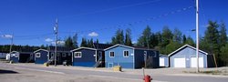
Researchers from the CEN have been working in this region since 1994, but the station was established in 1999 and was upgraded in 2010. The facility consists of three houses (3 bedrooms each), with a total capacity for 25 people, a laboratory building with a chemical hut, a meeting room, and a workshop.

General research and databases

Past research has focused on regional ecosystem dynamics, specifically on the response of the forest to disturbances such as fire and insect outbreaks, dendrochronology, riparian vegetation, snow, secular variations in water levels, hydrology, climate and reservoirs, greenhouse gas emission by reservoirs, and limnology. Research topics have covered issues on wildlife (birds, caribou, small mammals, and fish) and vegetation (biodiversity). CEN operates three climate stations in the area, one of which is near the town, another is in the centre of the LG2 reservoir, and a third is approximately 350 km inland on an island of the LaForge 1 reservoir. Besides scientific literature, CEN has also collected extensive climate datasets since 1996, which are available through Nordicana D: www.cen.ulaval.ca/nordicanad/.

Station Monitoring

Human dimension

The town of Radisson is located on the south shore of the La Grande River which drains the water from the LaGrande hydroelectric complex. It is the most northern French speaking community of Québec. It is also the only non-aboriginal community north of 53°N. Despite its remoteness, Radisson offers a wide array of services: i.e. gas station, hardware and grocery store, and a small hotel.

Access

Radisson is accessible by road. From Matagami, the James Bay route covers over 624 km. This route provides access to several Cree villages and trans-taiga ecosystems which border the hydroelectric reservoirs. It is a private road requiring user registration at the entry gate for security reasons. Contact CEN for more information (cen@cen.ulaval.ca).

Member of: