Address

Patrick Graillon, park section
Kativik Regional Government (KRG)
P.O. Box 9
Kuujjuaq, Québec
CANADA J0M 1C0

Station manager

Mickaél Lemay
E-mail: mickael.lemay@cen.ulaval.ca

Contact Station

Phone: +1 819 964-2961
E-mail: station@cen.ulaval.ca

http://www.cen.ulaval.ca/en/station.php?id=323&nm=lec

Station Features

Opening year: 2005 Status: Open
  • Type of station: Station
  • Operational period – year-round or Month A to Month B: Year-round
  • Name of station owner: CEN/Université Laval in collaboration with Kativik Regional government/Tursujuq Park
  • Type of owner: Government
  • Name of managing institution: CEN/Université Laval
  • Managing Institution Country: Canada
  • Station owner country: Canada
  • Partner institution: Yes
  • Partner institution name: Kativik Regional government/Tursujuq Park Véronique Nadeau, Conservation and Education Specialist E-mail: v.nadeau@krg.ca
  • Station latitude: 56,33777222
  • Station longitude: -74,61688333
  • Country (station location): Canada
  • Altitude of station: 224 m a.s.l
  • Min. altitude within study area: 215 m a.s.l
  • Max. altitude within study area: 400 m a.s.l
  • Nearest town/settlement: Umiujaq
  • Distance to nearest town/settlement: 135 km
  • Number of residents in nearest town: 400
  • Distance to nearest research station: 122 km
  • Maps available at station: Aerial image, Google Earth
  • Climate zone: Sub-Arctic
  • Period of measurments for climate data below [year to year]: Since 1995
  • Mean annual temperature: -3 °C
  • Mean temperature in February: -22,4 °C
  • Mean temperature in July: 11,8 °C
  • Precipitation type: Snow, Rain, Hail
  • Sea ice break up: July
  • Dominant wind direction: South
  • Mean annual wind speed: 5,9 m/s
  • Maximum wind speed (absolute): 28,3 m/s
  • Landscape features Valleys, Lake, River, Sea
  • Permafrost zone Discontinuous
  • Vegetation zone Tree line, Forest tundra, Peatlands, Wetlands, Peatlands/mires

Facilities

  • Area under roof: 50 m²
  • Max. number of visitors at a time : 11
  • Showers: Yes
  • Laundry facilities: No
  • Power supply – period (from ‘hour’ to ‘hour’ or 24 hours): 24 hours
  • Power supply - plug type A, B
  • Logistics area: 25 m²
  • Means of transportation to/from station Chartered plane/helicopter
  • Air transport landing facilities at station Airstrip, Helipad
  • Airstrip (Length × Width) : 600 × 400 m (lake: yes)
  • Airstrip surface : Gravel/Sand
  • Transport on land - at station Snowmobile
  • Transport on water - at station Zodiac, Closed boat
  • Number of staff peak season/summer: 0
  • Number of staff off season/winter: 0
  • Laboratory area: 25 m²

Science

  • Transnational Access: No
  • Remote Access: No
  • INTERACT Virtual Access: No
  • Permitting issues categories
    • Permits required for access to the station
    • Permits required for studies
  • Partner institutions (involved in the operation of the station)
    • Partner institution
  • Climate
    • Snow
    • Rain
    • Hail
  • Housing and accomodation
    • Showers
    • Laundry facilities
    • A
    • B
    • C
    • D
    • E
    • F
    • G
    • H
    • I
    • J
    • K
    • L
    • M
    • N
    • O
    • Municipal grid
    • Diesel/oil/gas
    • Wood
    • Solar
    • Wind
    • Water
    • Geothermal
    • Biofuel
    • Other
  • Logistics
    • Electrical and IT technologies
    • Mechanical
    • Metal
    • Wood
    • Plexiglas
    • Other
    • Walk
    • None
    • Tracked vehicle
    • Truck
    • SUV (4x4)
    • Car
    • Zodiac
    • ATV
    • Snowmobile
    • Open boat/Dhinghy
    • Closed boat
    • Bicycles
    • Amphibie vehicle
    • Ski
    • Other
    • Snow shoes
    • KickSledges
    • Other
    • Ski
    • Snowmobile
    • Boat
    • Car
    • Tracked vehicle
    • Truck
    • SUV (4x4)
    • Bus
    • Train
    • Airstrip
    • Scheduled flight
    • Chartered plane/helicopter
    • Helipad
    • Other
    • None
    • Harbour/port
    • Warf/pier
    • Pontoon/float bridge
    • Barges
    • Beach
  • Aircraft landing facilities
    • Helipad
  • Features in the facility area
    • Permanent snowpatches
    • Mountain
    • Valley
    • Lake
    • River
    • Shoreline
    • Tree line
    • Polar deserts/semi-deserts
    • Shrub tundra
    • Gramminoid tundra
    • Forest tundra
    • Peatlands
    • Wetlands
    • Palsa mires
    • Deciduous forest
    • Evergreen forest
    • Human settlements or resource use in the area
    • Arable land
    • Other
  • Main science disciplines
    • Astronomy
    • Atmospheric sciences
    • Cryology
    • Geology
    • Hydrology
    • Limnic biology
    • Marine biology
    • Terrestrial biology
    • Human biology
    • Anthropology
    • Archaeology
    • Sociology
    • Climate change
    • Environmental science (incl. pollution)
    • Oceanography
    • Agriculture
    • Animal husbandry
    • Fisheries
    • Forestry
    • Hunting
    • Tourism
  • Workshop facilities
    • Metal workshop
    • Wood workshop
    • Plexiglas workshop
    • Staff available to assist with constructions
  • Communication
    • Telephone
    • Satellite phone
    • VHF
    • E-mail
    • Internet
    • Computer
    • Printer
    • Scanner
    • Fax
  • Meteorology
    • Air temperature
    • Air humidity
    • Air pressure
    • Wind velocity
    • Wind direction
    • Precipitation
  • Sub-surface characteristics
    • Ground surface temperature
    • Soil temperature
    • Soil moisture
    • Ground water table
    • Soil water chemistry
    • Active layer depth
    • Permafrost distribution
    • Permafrost thickness
    • Permafrost temperature
  • Geology/Geomorphology
    • Quaternary geology
    • Sedimentology
    • Bedrock geology
    • Erosion
  • Landscape and environment
    • Mountains
    • Nunataks
    • Volcano/crater
    • Lava fields
    • Plateaus
    • Moraines
    • Valleys
    • Homothermic Springs
    • Lake
    • Thermokarst lake
    • River
    • Delta/estuarie
    • Fjord
    • Sea
    • Continuous
    • Discontinuous
    • Beach
    • Sporadic
    • Rocky shores
    • Pingos/ice lenses
    • Sea cliffs
    • Other (text)
    • Palsa mires
    • None
    • Ice Caps
    • Glaciers
    • Permanent snow patches
    • None
    • Tree line
    • Polar desert/Semi-desert
    • Gramminoid tundra
    • Shrub tundra
    • Forest tundra
    • Wetlands
    • Peatlands/mires
    • Salt marshes/lagoons
    • Heath
    • Grassland
    • Deciduous forest
    • Evergreen forest
    • Terrestrial carnivores
    • Alpine heath
    • Ungulates
    • Hares
    • Other (text)
    • Rodents
    • Bird colonies
    • Polar bear
    • Whales
    • Seals
    • Fish
    • Settlement
    • Fishing
    • Hunting
    • Forestry
    • Agriculture
    • Tourism
    • Animal husbandry
    • Leisure activities
  • Laboratory
    • Freezer < -80
    • Freezer -40 - -10
    • Fridge
    • Microscopes
    • Basic laboratory equipment
    • Advanced laboratory equipment
    • Basic chemical reagents
    • Analytical instrumentation
    • Other
    • Laboratory available in nearby town/settlement

Station name and owner

The CEN Clearwater Lake Research Station is legally owned by the Kativik Regional Government (KRG), but is operated by the Centre d&rsquo;&eacute;tudes Nordiques (CEN: Centre for Northern &shy;Studies) through a long term lease. This station is part of the CEN Network, more precisely the Qaujisarvik Network of stations and is part of a provincial park that is co-managed by KRG and the government of Qu&eacute;bec (Tursujuq National Park).

Location

Situated in Nunavik on the shores of Clearwater Lake (Lac à l’ Eau Claire, 56°20’ N, 74°27’ W), the station is about 125 km inland from the eastern coast of Hudson Bay.

Climate data

Grey colours are WMO Climate Normals including maximum and minimum values. Blue colours are individual years.

Climate data for the stations where extracted via Copernicus Climate Data Store, from the global gridded reanalysis product: ERA5 monthly averaged data on single levels from 1940 to present. Description and source code: Roemer J.K. 2023. https://doi.org/10.5281/zenodo.10214922 Data Source: Hersbach et al. 2023. Copernicus Climate Change Service (C3S) Climate Data Store (CDS), https://doi.org/10.24381/cds.f17050d7

Biodiversity and natural environment

Clearwater Lake is the second largest natural lake of the province of Québec (2243 km2). It sits at an altitude of 240 m, the limit reached by the postglacial sea, and drains into Hudson Bay via Clearwater River (Rivière à l’ Eau-Claire) with a maximum outflow rate of 150 m3/s. The lake features two adjacent, circular basins (26 and 36 km in diameter) that were created by a meteoritic impact about 290 ± 20 million years ago (Permian Age). Even though vascular plant diversity is low on regional granite gneisses, the volcanic breccias (clastic-textured extrusive igneous rocks) situated on the islands of the western basin (11 islands forming a circle) are populated by 250 vascular species, 15% of which are specific to the shores. Avifauna is abundant and the islands constitute an enclave for shrub tundra in an area that is rather characterised by forest tundra.

History and facilities

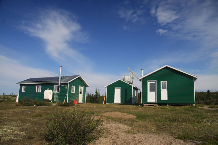
CEN research has been conducted here since 1980, but the station buildings are recent, built in 2000 and upgraded in 2011. The buildings were originally built by outfitters but have been considerably upgraded by the CEN. The three buildings can accommodate nine people. They are equipped with solar-powered electricity, running water, dry toilettes, and oil heating. The station is accessible from June to October by float plane or helicopter. About 10 km to the southeast, there is a natural airstrip maintained by Air Inuit. However, a river separates the station from the airstrip.

General research and databases

Past research has focused on regional ecosystem dynamics, specifically on the response of the forest to disturbances such as fire and insect outbreaks, dendrochronology, riparian vegetation and biodiversity, periglacial processes, secular variations in water levels, and hydrology. Other research topics have covered limnology of the two basins, geological and geomorphological history, and biophysical features of the area. Wildlife studies (birds, caribou, small mammals, fish, and biting insects) have also been conducted, as well as archeological studies (recently). CEN operates three climate stations in and around the western basin of the lake, one of which is on a small island directly in the centre of the basin. In addition to scientific literature, CEN has extensive climate data since 1986 which are available through Nordicana D: www.cen.ulaval.ca/nordicanad/.

Station Monitoring

Human dimension

Clearwater Lake is situated within the boundaries of a provincial park and on aboriginal land. First Nations people, the Cree, still use the land extensively for hunting and fishing, especially during spring and autumn. There are no permanent settlements around the station, the closest village Umiujaq is about 135 km west on the shores of Hudson Bay. Access to the station is organised by CEN from the Whapmagoostui-Kuujjuarapik Research Station.

Access

Clearwater Lake is an isolated station in a provincial park; therefore all research activities must be proposed and planned in advance. Contact CEN for more information (cen@cen.ulaval.ca).

Member of: