Address

Labrador Institute Research Station
Labrador Institute of Memorial University
North West River, Newfoundland and Labrador
A0P 1M0
Canada

Station manager

Ashlee Cunsolo
E-mail: ashlee.cunsolo@mun.ca

Contact Station

Phone: +1 (709) 497-3630, Ext: 222

www.mun.ca/labradorinstitute

Station Features

Opening year: 1978 Status: Open
  • Type of station: Station
  • Operational period – year-round or Month A to Month B: Year-round
  • Name of station owner: NL Department of Works, Services, and Transportation
  • Type of owner: Government
  • Name of managing institution: Labrador Institute
  • Managing Institution Country: Canada
  • Station owner country: Canada
  • Partner institution: No
  • Station latitude: 53,52559740
  • Station longitude: -60,14182800
  • Country (station location): Canada
  • Altitude of station: 21 m a.s.l
  • Min. altitude within study area: 0 m a.s.l
  • Max. altitude within study area: 1600 m a.s.l
  • Nearest town/settlement: North West River
  • Distance to nearest town/settlement: 0 km
  • Number of residents in nearest town: 0
  • Distance to nearest research station: 595 km
  • Maps available at station: Map (1:50 000), aerial image, satellite image, Google Earth
  • Climate zone: Boreal
  • Period of measurments for climate data below [year to year]: 1941-2014
  • Mean annual temperature: 0 °C
  • Mean temperature in February: -15,7 °C
  • Mean temperature in July: 15,1 °C
  • Precipitation type: Rain, snow
  • Sea ice break up: June, July
  • Dominant wind direction: West
  • Mean annual wind speed: 4,2 m/s
  • Maximum wind speed (absolute): 21 m/s
  • Landscape features Mountains, Valleys, Lake, River, Sea
  • Permafrost zone Sporadic
  • Snow and ice on land Permanent snow patches
  • Vegetation zone Tree line, Shrub tundra, Gramminoid tundra, Forest tundra, Peatlands, Wetlands, Peatlands/mires, Deciduous forest, Evergreen forest
  • Human use Settlement

Facilities

  • Area under roof: 1400 m²
  • Max. number of visitors at a time : 50
  • Showers: Yes
  • Laundry facilities: Yes
  • Power supply – period (from ‘hour’ to ‘hour’ or 24 hours): 24 hours
  • Power supply - plug type A, B
  • Logistics area: 0 m²
  • Means of transportation to/from station Car
  • Airstrip (Length × Width) : Airport in Goose Bay (33 km) away via highway
  • Transport on land - at station Car
  • Transport on water - at station Open boat/Dhinghy
  • Number of staff peak season/summer: 20
  • Number of staff off season/winter: 20
  • Medical facilities: Yes
  • Medical capability Basic
  • Distance to hospital (estimated time – hours): 33
  • Laboratory area: 400 m²

Science

  • Transnational Access: No
  • Remote Access: No
  • INTERACT Virtual Access: No
  • Permitting issues categories
    • Permits required for access to the station
    • Permits required for studies
  • Partner institutions (involved in the operation of the station)
    • Partner institution
  • Climate
    • Snow
    • Rain
    • Hail
  • Housing and accomodation
    • Showers
    • Laundry facilities
    • A
    • B
    • C
    • D
    • E
    • F
    • G
    • H
    • I
    • J
    • K
    • L
    • M
    • N
    • O
    • Municipal grid
    • Diesel/oil/gas
    • Wood
    • Solar
    • Wind
    • Water
    • Geothermal
    • Biofuel
    • Other
  • Logistics
    • Electrical and IT technologies
    • Mechanical
    • Metal
    • Wood
    • Plexiglas
    • Other
    • Walk
    • None
    • Tracked vehicle
    • Truck
    • SUV (4x4)
    • Car
    • Zodiac
    • ATV
    • Open boat/Dhinghy
    • Snowmobile
    • Closed boat
    • Bicycles
    • Amphibie vehicle
    • Ski
    • Other
    • Snow shoes
    • KickSledges
    • Other
    • Ski
    • Snowmobile
    • Boat
    • Car
    • Tracked vehicle
    • Truck
    • SUV (4x4)
    • Bus
    • Train
    • Airstrip
    • Scheduled flight
    • Chartered plane/helicopter
    • Helipad
    • Other
    • None
    • Harbour/port
    • Warf/pier
    • Pontoon/float bridge
    • Barges
    • Beach
  • Aircraft landing facilities
    • Helipad
  • Features in the facility area
    • Permanent snowpatches
    • Mountain
    • Valley
    • Lake
    • River
    • Shoreline
    • Tree line
    • Polar deserts/semi-deserts
    • Shrub tundra
    • Gramminoid tundra
    • Forest tundra
    • Peatlands
    • Wetlands
    • Palsa mires
    • Deciduous forest
    • Evergreen forest
    • Human settlements or resource use in the area
    • Arable land
    • Other
  • Main science disciplines
    • Astronomy
    • Atmospheric sciences
    • Cryology
    • Geology
    • Hydrology
    • Limnic biology
    • Marine biology
    • Terrestrial biology
    • Human biology
    • Anthropology
    • Archaeology
    • Sociology
    • Climate change
    • Environmental science (incl. pollution)
    • Oceanography
    • Agriculture
    • Animal husbandry
    • Fisheries
    • Forestry
    • Hunting
    • Tourism
  • Workshop facilities
    • Metal workshop
    • Wood workshop
    • Plexiglas workshop
    • Staff available to assist with constructions
  • Communication
    • Telephone
    • Satellite phone
    • VHF
    • E-mail
    • Internet
    • Computer
    • Printer
    • Scanner
    • Fax
  • Landscape and environment
    • Mountains
    • Nunataks
    • Volcano/crater
    • Lava fields
    • Plateaus
    • Moraines
    • Valleys
    • Homothermic Springs
    • Lake
    • Thermokarst lake
    • River
    • Delta/estuarie
    • Fjord
    • Sea
    • Continuous
    • Discontinuous
    • Beach
    • Sporadic
    • Rocky shores
    • Pingos/ice lenses
    • Sea cliffs
    • Other (text)
    • Palsa mires
    • Ice Caps
    • None
    • Glaciers
    • Permanent snow patches
    • None
    • Tree line
    • Polar desert/Semi-desert
    • Gramminoid tundra
    • Shrub tundra
    • Forest tundra
    • Wetlands
    • Peatlands/mires
    • Salt marshes/lagoons
    • Heath
    • Grassland
    • Deciduous forest
    • Evergreen forest
    • Terrestrial carnivores
    • Alpine heath
    • Ungulates
    • Hares
    • Other (text)
    • Rodents
    • Bird colonies
    • Polar bear
    • Whales
    • Seals
    • Fish
    • Settlement
    • Fishing
    • Hunting
    • Forestry
    • Agriculture
    • Tourism
    • Animal husbandry
    • Leisure activities
  • Medical facilities
    • Medical facilities
    • Basic
    • Medium
    • Extensive
    • Dental
    • Surgery
    • Other
    • No
    • In peak season
    • When open
  • Laboratory
    • Freezer < -80
    • Freezer -40 - -10
    • Fridge
    • Microscopes
    • Basic laboratory equipment
    • Advanced laboratory equipment
    • Basic chemical reagents
    • Analytical instrumentation
    • Other
    • Laboratory available in nearby town/settlement

Station name and owner

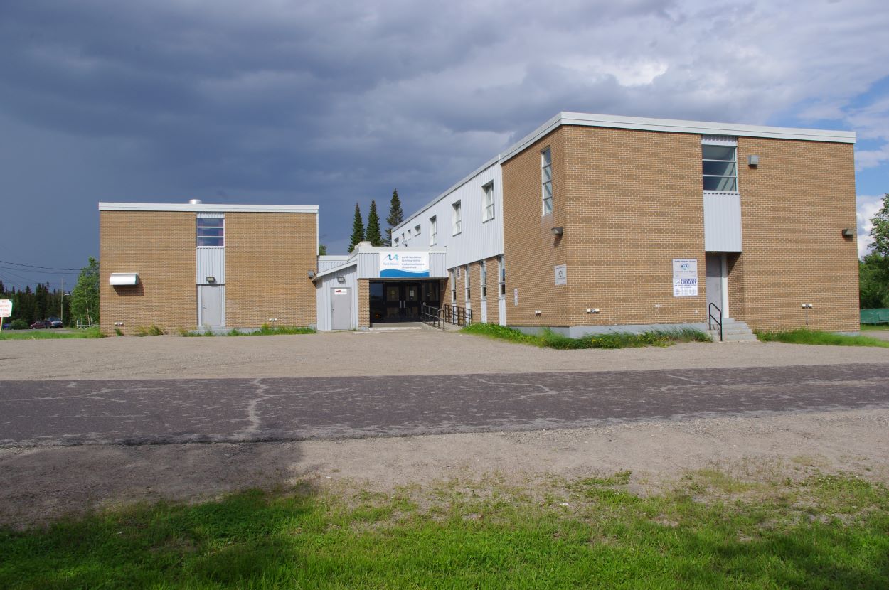
The Labrador Institute Research Station (LIRS) is located in North West River, Newfoundland and Labrador. It is operated by the Labrador Institute of Memorial University. The building is owned by the Newfoundland and Labrador (NL) Provincial Government’s Department of Transportation and Works.”

Location

LIRS’s main offices are located in Happy Valley-Goose Bay, NL, with a satellite office located in Labrador City, NL. NWR is centrally located and its population is made up of Inuit, Euro-Canadian, Innu and Metis people. LIRS is located in the Taiga/Boreal Forest Region.

Climate data

Grey colours are WMO Climate Normals including maximum and minimum values. Blue colours are individual years.

Climate data for the stations where extracted via Copernicus Climate Data Store, from the global gridded reanalysis product: ERA5 monthly averaged data on single levels from 1940 to present. Description and source code: Roemer J.K. 2023. https://doi.org/10.5281/zenodo.10214922 Data Source: Hersbach et al. 2023. Copernicus Climate Change Service (C3S) Climate Data Store (CDS), https://doi.org/10.24381/cds.f17050d7

Biodiversity and natural environment

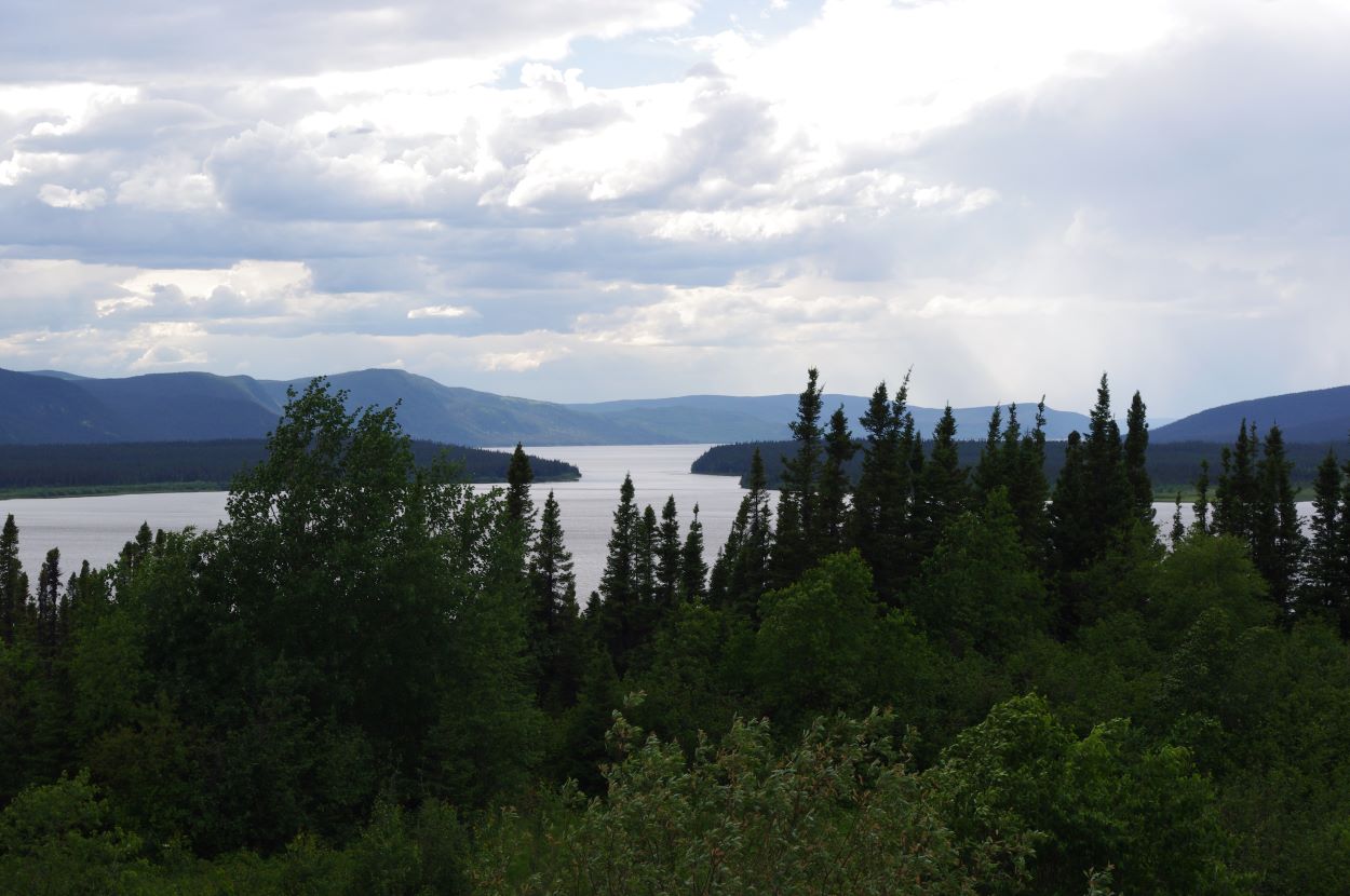
North West River experiences generally mild summers with cold winters. Winters usually begin in mid-November and last until mid-April and summers begin in June and end in early September. The temperature generally ranges from about -30 °C at its coldest in the winters to about 30 °C in the summers. The town is on a hill dividing Little Lake from the larger Lake Melville. A small band of water (North West River) connects the two. The area of North West River is located on a sandy plain surrounded by mountains. NWR falls within the Lake Melville Ecoregion, which is a unique ecosystem within Labrador. Immediately adjacent to the community are important waterfowl staging areas, seabird breeding colonies, and important breeding habitats for a variety of marine mammals. The nearby Mealy and Red Wine Mountains have endangered herds of woodland caribou. The eastern end of Lake Melville has been designated as an internationally Important Bird Area due to the high concentrations of moulting scoters in late summer. Numerous archaeological discoveries have been made in the area, the oldest of which is the Maritime Archaic Indian site dating 5000 bp.

History and facilities

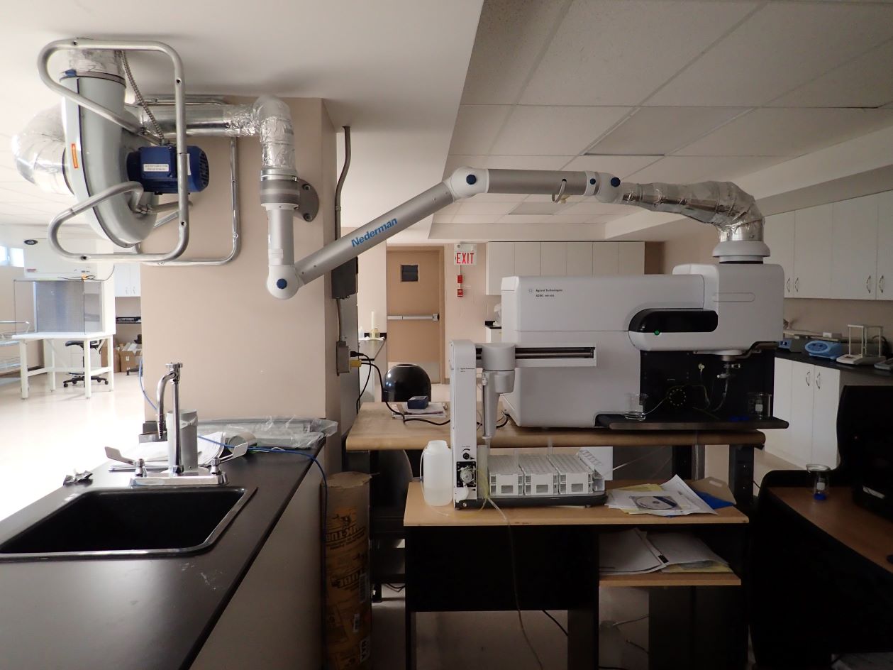
The facility is new but is seeing an increasing amount of use. The station is co-located with the College of the North Atlantic and the NWR Community Library, and includes employee and general office space, large board room, scientific laboratory, GIS/social science laboratory, general (wet) laboratory, archaeology lab, accommodation for four people, full kitchen and dining area, and storage and laundry space. Our primary scientific lab is currently being developed. Equipment includes: digital balances, a variety of microscopes, incubators, sample freezer, water purification, pH testing kit, centrifuge, digestion block, water bath, large volume stirrer, portable ventilation system, etc. There are more than seven work stations, sinks, teaching area, and lots of open space for further development. Also included: satellite internet and telephone service.

General research and databases

LIRS is just coming online, but the Labrador Institute (LI) has a long history of research in Labrador in many disciplines, including but not limited to health research, arts and culture, social programs, climate change, archaeology, education, mining and resource development history, migratory birds, and land mammals. Currently, the LIRS is supporting and/or taking part in climate change research, land use studies, interior archaeology, archaeological mitigation, addictions awareness, aquatic ecology, soil amendment research, and mine tailings remediation. LIRS and LI are currently undergoing a period of significant growth. As a result, we will increase our capacity in environmental studies, climate change, earth sciences, anthropology, archaeology, and geography. We will also be starting an artist in residence programme.

Station Monitoring

Human dimension

The research station is located in North West River, Central Labrador. Central Labrador has been inhabited by the Innu and Inuit for over 6000 years. The NunatuKavut community council land claim is also nearby, though this claim has not been settled, and the proposed Mealy Mountain National Park is also just across Lake Melville from LIRS.

Access

NWR is accessible by road all year round. Goose Bay Airport is a 30 minute drive from the station. Chartered boats are available in summer; snowmobiles may be rented in winter; rental cars are available year-round in Happy Valley-Goose Bay. The airport has modern facilities including helicopters and bush planes for charter, and coastal trawlers are available.

Member of: