Address

Arctic Station
3953 Qeqertarsuaq
Greenland

Station manager

Aart Kroon
E-mail: ak@ign.ku.dk

Contact Station

E-mail: gin@science.ku

http://arktiskstation.ku.dk/english

Station Features

Opening year: 1906 Status: Open
  • Type of station: Station
  • Operational period – year-round or Month A to Month B: Year-round
  • Name of station owner: Faculty of Science, University of Copenhagen
  • Type of owner: Research institution
  • Name of managing institution: Arctic Station administration, Faculty of Science, University of Copenhagen
  • Managing Institution Country: Denmark
  • Station owner country: Denmark
  • Partner institution: No
  • Station latitude: 69,25337222
  • Station longitude: -53,51724444
  • Country (station location): Greenland
  • Altitude of station: 20 m a.s.l
  • Min. altitude within study area: 0 m a.s.l
  • Max. altitude within study area: 800 m a.s.l
  • Nearest town/settlement: Qeqertarsuaq 
  • Distance to nearest town/settlement: 1 km
  • Number of residents in nearest town: 850
  • Distance to nearest research station: 262 km
  • Maps available at station: Various maps are avaiable at the station, satellite images, and Google Earth
  • Climate zone: High Arctic
  • Period of measurments for climate data below [year to year]:
  • Mean annual temperature: -3,2 °C
  • Mean temperature in February: -11,6 °C
  • Mean temperature in July: 7,6 °C
  • Precipitation type: Rain, snow
  • Lake ice break up: June
  • Dominant wind direction: East
  • Mean annual wind speed: 4,3 m/s
  • Maximum wind speed (absolute): 23,6 m/s
  • Landscape features Mountains, Plateaus, Valleys, Homothermic Springs, Lake, River, Sea
  • Permafrost zone Discontinuous
  • Snow and ice on land Ice Caps, Glaciers, Permanent snow patches
  • Vegetation zone Polar desert/Semi-desert, Shrub tundra, Gramminoid tundra, Peatlands, Wetlands, Peatlands/mires
  • Wildlife Hares, Polar bear, Whales, Seals, Fish
  • Human use Settlement, Fishing, Hunting

Facilities

  • Area under roof: 955 m²
  • Max. number of visitors at a time : 26
  • Showers: Yes
  • Laundry facilities: Yes
  • Power supply – period (from ‘hour’ to ‘hour’ or 24 hours): 24 Hours
  • Power supply - plug type C, E, F, K
  • Logistics area: 70 m²
  • Workshops Electrical and IT technologies, Mechanical, Metal, Plexiglas, Wood
  • Means of transportation to/from station Walk, Other
  • Air transport landing facilities at station Helipad
  • Airstrip (Length × Width) :
  • Airstrip surface : Tarmac/Concrete
  • Transport on land - at station Snowmobile, Car
  • Transport on water - at station Closed boat
  • Water landing facilities Warf/pier
  • Number of staff peak season/summer: 3
  • Number of staff off season/winter: 3
  • Compulsory safety equipment VHF
  • Recommended safety equipment Weapon/rifle, Other
  • Laboratory area: 225 m²
  • Field to station Mobile phone, VHF, Satellite phone
  • Station to outside world Mobile phone, Internet
  • IT Infrastructure Wifi, Computers, Printer
  • Medical facilities: Yes
  • Medical capability Basic
  • Staff with medical training/doctor No
  • Distance to hospital (estimated time – hours): 2

Science

  • Transnational Access: Yes
  • Remote Access: No
  • INTERACT Virtual Access: Yes
  • Permitting issues categories
    • Permits required for access to the station
    • Permits required for studies
  • Partner institutions (involved in the operation of the station)
    • Partner institution
  • Climate
    • Snow
    • Rain
    • Hail
  • Housing and accomodation
    • Showers
    • Laundry facilities
    • A
    • B
    • C
    • D
    • E
    • F
    • G
    • H
    • I
    • J
    • K
    • L
    • M
    • N
    • O
    • Municipal grid
    • Diesel/oil/gas
    • Wood
    • Solar
    • Wind
    • Water
    • Geothermal
    • Biofuel
    • Other
  • Logistics
    • Electrical and IT technologies
    • Mechanical
    • Metal
    • Wood
    • Plexiglas
    • Other
    • Walk
    • None
    • Tracked vehicle
    • Truck
    • SUV (4x4)
    • Car
    • Zodiac
    • ATV
    • Snowmobile
    • Open boat/Dhinghy
    • Closed boat
    • Bicycles
    • Amphibie vehicle
    • Ski
    • Other
    • Snow shoes
    • KickSledges
    • Other
    • Ski
    • Snowmobile
    • Boat
    • Car
    • Tracked vehicle
    • Truck
    • SUV (4x4)
    • Bus
    • Train
    • Airstrip
    • Scheduled flight
    • Helipad
    • Chartered plane/helicopter
    • Other
    • None
    • Harbour/port
    • Warf/pier
    • Pontoon/float bridge
    • Barges
    • Beach
  • Aircraft landing facilities
    • Helipad
  • Features in the facility area
    • Permanent snowpatches
    • Mountain
    • Valley
    • Lake
    • River
    • Shoreline
    • Tree line
    • Polar deserts/semi-deserts
    • Shrub tundra
    • Gramminoid tundra
    • Forest tundra
    • Peatlands
    • Wetlands
    • Palsa mires
    • Deciduous forest
    • Evergreen forest
    • Human settlements or resource use in the area
    • Arable land
    • Other
  • Main science disciplines
    • Astronomy
    • Atmospheric sciences
    • Cryology
    • Geology
    • Hydrology
    • Limnic biology
    • Marine biology
    • Terrestrial biology
    • Human biology
    • Anthropology
    • Archaeology
    • Sociology
    • Climate change
    • Environmental science (incl. pollution)
    • Oceanography
    • Agriculture
    • Animal husbandry
    • Fisheries
    • Forestry
    • Hunting
    • Tourism
  • Workshop facilities
    • Metal workshop
    • Wood workshop
    • Plexiglas workshop
    • Staff available to assist with constructions
  • Communication
    • Telephone
    • Satellite phone
    • VHF
    • E-mail
    • Internet
    • Computer
    • Printer
    • Scanner
    • Fax
  • Meteorology
    • Air temperature
    • Air humidity
    • Air pressure
    • Wind velocity
    • Wind direction
    • Precipitation
  • Energy balance and radiation
    • Energy balance
    • Short wave incoming
    • Short wave outgoing
    • Long wave incoming
    • Long wave outgoing
    • Net radiation
    • UV-B
    • Multi-spectral
    • Cloud cover/hours of sunshine
  • Sub-surface characteristics
    • Ground surface temperature
    • Soil temperature
    • Soil moisture
    • Ground water table
    • Soil water chemistry
    • Active layer depth
    • Permafrost distribution
    • Permafrost thickness
    • Permafrost temperature
  • Snow characteristics
    • Snow depth
    • Snow cover
    • Snow density
    • Snow temperature
  • Atmospheric composition
    • CO<sub>2</sub> concentration
    • CH<sub>4</sub> concentration
  • Greenhouse gas exchange
    • CO<sub>2</sub> exchange
    • CH<sub>4</sub> exchange
    • N<sub>2</sub>O exchange
  • Energy budget
    • Net radiation
    • Sensible heat flux
    • Latent heat flux
    • Soil heat flux
  • Hydrology/Limnology
    • River water discharge/water level
    • Lake water level
    • Water balance
    • Water temperature
    • Lake ice cover (formation/breakup/thickness)
    • Suspended sediment discharge
    • Organic matter discharge
    • PAR (Photosyntetically Active Radiation)/secchi depth
    • Water chemistry
  • Mass balace
    • Mass balance
    • Snow water equivalent
    • Snowcover stratigraphy
    • Equilibrium Line Altitude
    • Duration of snow cover
    • Calving flux
  • Climate
    • Climate measurements
    • Energy balance
  • Vegetation
    • Flowering phenology
    • Amount of flowering
    • NDVI (plot/transect)
    • Landscape NDVI (from satellite images)
    • Vascular plant community composition
    • Bryophyte community composition
    • Lichen community composition
    • Fungi community composition
    • Berry production
    • Aerobiological monitoring (pollen, spores, etc.)
    • Species list (community composition)
  • Lake ecology
    • Phytoplankton (including chlorophyll)
    • Zooplankton
    • Vegetation
    • Fish
    • Invertebrates
    • Species list (community composition)
  • Landscape and environment
    • Mountains
    • Nunataks
    • Volcano/crater
    • Lava fields
    • Plateaus
    • Moraines
    • Valleys
    • Homothermic Springs
    • Lake
    • Thermokarst lake
    • River
    • Delta/estuarie
    • Fjord
    • Sea
    • Continuous
    • Discontinuous
    • Beach
    • Sporadic
    • Rocky shores
    • Pingos/ice lenses
    • Sea cliffs
    • Other (text)
    • Palsa mires
    • Ice Caps
    • None
    • Glaciers
    • Permanent snow patches
    • None
    • Tree line
    • Polar desert/Semi-desert
    • Gramminoid tundra
    • Shrub tundra
    • Forest tundra
    • Wetlands
    • Peatlands/mires
    • Salt marshes/lagoons
    • Heath
    • Grassland
    • Deciduous forest
    • Terrestrial carnivores
    • Evergreen forest
    • Alpine heath
    • Ungulates
    • Hares
    • Other (text)
    • Rodents
    • Bird colonies
    • Polar bear
    • Whales
    • Seals
    • Fish
    • Settlement
    • Fishing
    • Hunting
    • Forestry
    • Agriculture
    • Tourism
    • Animal husbandry
    • Leisure activities
  • Field equipment
    • PLB
    • VHF
    • HF
    • Satellite phone
    • Mobile phone
    • GPS
    • Weapon/rifle
    • Flare gun
    • Bearspray
    • PLB
    • First aid kit
    • Glacier rescue kit
    • VHF
    • Avalanche rescue kit
    • HF
    • Satellite phone
    • Overnight equipment
    • Other
    • Mobile phone
    • GPS
    • Weapon/rifle
    • Flare gun
    • Bearspray
    • PLB
    • First aid kit
    • Glacier rescue kit
    • VHF
    • Avalanche rescue kit
    • HF
    • Satellite phone
    • Overnight equipment
    • Other
    • Mobile phone
    • GPS
    • Weapon/rifle
    • Flare gun
    • Bearspray
    • Tent
    • First aid kit
    • Glacier rescue kit
    • Sleeping matress
    • Avalanche rescue kit
    • Sleeping bag
    • Cooking equipment and utensils
    • Overnight equipment
    • Other
    • Gas/alcohol for cooking
    • Field power supply available at station
  • Laboratory
    • Freezer < -80
    • Freezer -40 - -10
    • Fridge
    • Microscopes
    • Basic laboratory equipment
    • Advanced laboratory equipment
    • Basic chemical reagents
    • Analytical instrumentation
    • Other
    • Laboratory available in nearby town/settlement
  • Communication and IT
    • Mobile phone
    • VHF
    • Satellite phone
    • Other
    • Satellite phone
    • Mobile phone
    • Internet
    • Other
    • Wireless transfer of data from field site to station
    • Wifi
    • Computers
    • Printer
    • Data storage
    • Statistical tools
    • GIS tools
    • Other
  • Medical facilities
    • Medical facilities
    • Basic
    • Medium
    • Extensive
    • Dental
    • Surgery
    • Other
    • No
    • In peak season
    • When open

Station name and owner

Owner of the Arctic Station in Greenland is the Faculty of Science at the University of Copenhagen, Denmark.

Location

The Arctic Station is located on the south coast of the Disko Island in central West Greenland (69°15’ N, 53°34’ W). It is facing the Disko Bay/Davis Strait and is characterised by a low arctic, coastal climate. Some of the world’s largest icebergs drift by the Arctic Station .

Climate data

Grey colours are WMO Climate Normals including maximum and minimum values. Blue colours are individual years.

Climate data for the stations where extracted via Copernicus Climate Data Store, from the global gridded reanalysis product: ERA5 monthly averaged data on single levels from 1940 to present. Description and source code: Roemer J.K. 2023. https://doi.org/10.5281/zenodo.10214922 Data Source: Hersbach et al. 2023. Copernicus Climate Change Service (C3S) Climate Data Store (CDS), https://doi.org/10.24381/cds.f17050d7

Biodiversity and natural environment

The surroundings of Arctic Station are characterised by a large variety in landscape, flora, and fauna. The station and the nearby town Qeqertarsuaq are situated on a ridge of Precambrian gneisses overlain by massive basalts from the Tertiary. The surrounding mountains have an altitude of 600-800 m a.s.l. Three major valley glaciers, Lyngmarksbræen, Chamberlain’s Glacier, and Petersen’s Glacier, can be visited on a single day trip. The area around Qeqertarsuaq is situated in the transition zone between continuous and discontinuous permafrost. A large variety of periglacial phenomena can be studied, i.e. ice- and sand wedges, stone polygons, mud circles, as well as palsa and pingo formations. The coastline is situated only 300 m south of the station along a 100 m wide sandy coastal barrier. The vegetation within the immediate surroundings of the Arctic Station is unique to low arctic Greenland. This is illustrated by the number of species of flowering plants within walking distance from the station: 212 of the 513 Greenlandic flower species occur in the area. This plant diversity is caused by a relatively favourable local climate, a high altitudinal gradient, rich soils, and several homothermic springs.

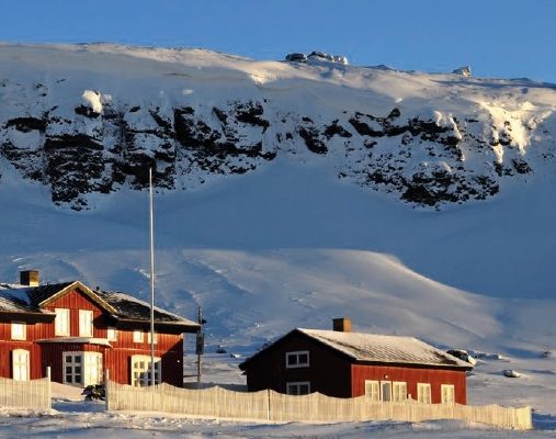
History and facilities

The botanist Morten Petersen Porsild founded the Arctic Station (“Den Danske Arktiske Station”) in 1906. The locality selected was c. 1 km east of the town Qeqertarsuaq (formerly Godhavn) which is located on the south coast of the Disko Island – also named Qeqertarsuaq. The idea of establishing an arctic research facility in Greenland was supported by famous explorers of the northern polar regions, e.g. Knud Rasmussen, Ludwig Mylius-Erichsen, and Fridtjof Nansen. The University of Copenhagen became the owner of the research facility in 1953. Arctic Station has around 150 Danish and international visitors, students, and researchers each year. Arctic Station has rooms for 26 people. Kitchen, living room, seminar room, scientific library, and laboratories are found at the station.

General research and databases

The surroundings of Arctic Station offer both terrestrial and marine environments, which makes the research station ideal for botanists, zoologists, geologists, geophysicists, and physical geographers. A meteorological station was established in 1990, and a full record of climate data exists since 1991. These monitoring data are available through Dr. Birger Ulf Hansen, University of Copenhagen, Institute for Geology and Geography (buh@ign.ku.dk).

Link to data: https://dataportal.eu-interact.org/stations

Station Monitoring

Human dimension

Arctic Station is located only 1 km east of the town Qeqertarsuaq (Godhavn) with a population of around 1000 inhabitants. The city was established in 1773 by Sven Sandgren. Whaling has always been very important for the city. Fishing and hunting are still among the primary occupations for the island’s inhabitants. Tourism is another major business. As something quite unique for Greenland, it is possible to ride a dog sledge on the local glaciers at Qeqertarsuaq under the midnight sun during summer. One can hike to the top of the Lyngmarksfjeld where efforts are rewarded by a fantastic view of Disko Bay and the gigantic icebergs at Ilulissat Icefjord almost 100 kilometres away.

Access

The Arctic Station can be visited without problems throughout the year. Qeqertarsuaq Heliport is served in winter by the Bell 212 helicopter. Air Greenland operates winter-only air services from Qeqertarsuaq Heliport to Ilulissat, Qasigiannguit, and Aasiaat. During summer and autumn, when the waters of Disko Bay are ice-free, transport between towns and settlements is by sea only. A ferry (Diskoline) links Qeqertarsuaq with Ilulissat, Aasiaat, and Qasigiannguit. For further information see www.diskoline.gl.

Member of: