Address

Department of Geosciences and Natural Resource Management
Geocenter Denmark
University of Copenhagen
DK 1350 Copenhagen K
Denmark

Station manager

Aart Kroon
E-mail: ak@ign.ku.dk

Contact Station

Phone: (+45) 35 32 25 00

https://ign.ku.dk/english/about/field-stations/sermilik-station/

Station Features

Opening year: 1970 Status: Open
  • Type of station: Station
  • Operational period – year-round or Month A to Month B: Mid June - Mid September
  • Name of station owner: Department for Geography and Geology, University of Copenhagen, Denmark
  • Type of owner: Research institution
  • Name of managing institution: University of Copenhagen, Denmark
  • Managing Institution Country: Denmark
  • Station owner country: Denmark
  • Partner institution: No
  • Station latitude: 65,68097972
  • Station longitude: -37,91450243
  • Country (station location): Greenland
  • Altitude of station: 15 m a.s.l
  • Min. altitude within study area: 0 m a.s.l
  • Max. altitude within study area: 937 m a.s.l
  • Nearest town/settlement: Tasiilaq
  • Distance to nearest town/settlement: 20 km
  • Number of residents in nearest town: 2000
  • Distance to nearest public transport facility (Airport, Ferry terminal, Train station, Bus station): 0 km
  • Distance to nearest research station: 670 km
  • Maps available at station: 1:10 000 0 tourist map
  • Climate zone: Low Arctic
  • Period of measurments for climate data below [year to year]:
  • Mean annual temperature: -1,7 °C
  • Mean temperature in February: -7,5 °C
  • Mean temperature in July: 6,4 °C
  • Precipitation type: Snow, Rain
  • Sea ice break up: July
  • Lake ice break up: July
  • Mean annual wind speed: 0 m/s
  • Maximum wind speed (absolute): 0 m/s
  • Landscape features Mountains, Valleys, Lake, River, Fjord, Sea
  • Permafrost zone Discontinuous
  • Snow and ice on land Ice Caps, Glaciers
  • Vegetation zone Shrub tundra

Facilities

  • Area under roof: 100 m²
  • Max. number of visitors at a time : 6
  • Showers: Yes
  • Laundry facilities: No
  • Power supply – period (from ‘hour’ to ‘hour’ or 24 hours): 24 Hours
  • Power supply - plug type C, E, F, K
  • Power sources at station Diesel/oil/gas
  • Logistics area: 20 m²
  • Workshops Wood
  • Means of transportation to/from station Walk, Boat, Other
  • Air transport landing facilities at station Helipad
  • Airstrip (Length × Width) :
  • Water landing facilities Warf/pier
  • Number of staff peak season/summer: 0
  • Number of staff off season/winter: 0
  • Staff able to assist (fieldwork): No
  • Staff able to assist (workshops): No
  • Recommended safety equipment Weapon/rifle
  • Field to station VHF, Satellite phone
  • Station to outside world Other
  • Medical facilities: Yes
  • Medical capability Basic
  • Staff with medical training/doctor No
  • Distance to hospital (estimated time – hours): 20

Science

  • Transnational Access: Yes
  • Remote Access: No
  • INTERACT Virtual Access: No
  • Permitting issues categories
    • Permits required for access to the station
    • Permits required for studies
  • Partner institutions (involved in the operation of the station)
    • Partner institution
  • Climate
    • Snow
    • Rain
    • Hail
  • Housing and accomodation
    • Showers
    • Laundry facilities
    • A
    • B
    • C
    • D
    • E
    • F
    • G
    • H
    • I
    • J
    • K
    • L
    • M
    • N
    • O
    • Municipal grid
    • Diesel/oil/gas
    • Wood
    • Solar
    • Wind
    • Water
    • Geothermal
    • Biofuel
    • Other
  • Logistics
    • Electrical and IT technologies
    • Mechanical
    • Metal
    • Wood
    • Plexiglas
    • Other
    • Walk
    • None
    • Tracked vehicle
    • Truck
    • SUV (4x4)
    • Car
    • Zodiac
    • ATV
    • Open boat/Dhinghy
    • Snowmobile
    • Closed boat
    • Bicycles
    • Amphibie vehicle
    • Ski
    • Other
    • Snow shoes
    • KickSledges
    • Other
    • Ski
    • Snowmobile
    • Boat
    • Car
    • Tracked vehicle
    • Truck
    • SUV (4x4)
    • Bus
    • Train
    • Airstrip
    • Scheduled flight
    • Helipad
    • Chartered plane/helicopter
    • Other
    • None
    • Harbour/port
    • Warf/pier
    • Pontoon/float bridge
    • Barges
    • Beach
  • Aircraft landing facilities
    • Helipad
  • Features in the facility area
    • Permanent snowpatches
    • Mountain
    • Valley
    • Lake
    • River
    • Shoreline
    • Tree line
    • Polar deserts/semi-deserts
    • Shrub tundra
    • Gramminoid tundra
    • Forest tundra
    • Peatlands
    • Wetlands
    • Palsa mires
    • Deciduous forest
    • Evergreen forest
    • Human settlements or resource use in the area
    • Arable land
    • Other
  • Main science disciplines
    • Astronomy
    • Atmospheric sciences
    • Cryology
    • Geology
    • Hydrology
    • Limnic biology
    • Marine biology
    • Terrestrial biology
    • Human biology
    • Anthropology
    • Archaeology
    • Sociology
    • Climate change
    • Environmental science (incl. pollution)
    • Oceanography
    • Agriculture
    • Animal husbandry
    • Fisheries
    • Forestry
    • Hunting
    • Tourism
  • Workshop facilities
    • Metal workshop
    • Wood workshop
    • Plexiglas workshop
    • Staff available to assist with constructions
  • Communication
    • Telephone
    • Satellite phone
    • VHF
    • E-mail
    • Internet
    • Computer
    • Printer
    • Scanner
    • Fax
  • Meteorology
    • Air temperature
    • Air humidity
    • Air pressure
    • Wind velocity
    • Wind direction
    • Precipitation
  • Energy balance and radiation
    • Energy balance
    • Short wave incoming
    • Short wave outgoing
    • Long wave incoming
    • Long wave outgoing
    • Net radiation
    • UV-B
    • Multi-spectral
    • Cloud cover/hours of sunshine
  • Hydrology/Limnology
    • River water discharge/water level
    • Lake water level
    • Water balance
    • Water temperature
    • Lake ice cover (formation/breakup/thickness)
    • Suspended sediment discharge
    • Organic matter discharge
    • PAR (Photosyntetically Active Radiation)/secchi depth
    • Water chemistry
  • Glacier characteristics
    • Glacier area
    • Topography
    • Elevation change
    • Terminus position
    • Ice velocity
    • Ice thickness
    • Debris cover
    • Surface albedo/reflexion coefficient
  • Mass balace
    • Mass balance
    • Snow water equivalent
    • Snowcover stratigraphy
    • Equilibrium Line Altitude
    • Duration of snow cover
    • Calving flux
  • Climate
    • Climate measurements
    • Energy balance
  • Landscape and environment
    • Mountains
    • Nunataks
    • Volcano/crater
    • Lava fields
    • Plateaus
    • Moraines
    • Valleys
    • Homothermic Springs
    • Lake
    • Thermokarst lake
    • River
    • Delta/estuarie
    • Fjord
    • Sea
    • Continuous
    • Discontinuous
    • Beach
    • Sporadic
    • Rocky shores
    • Pingos/ice lenses
    • Sea cliffs
    • Other (text)
    • Palsa mires
    • Ice Caps
    • None
    • Glaciers
    • Permanent snow patches
    • None
    • Tree line
    • Polar desert/Semi-desert
    • Gramminoid tundra
    • Shrub tundra
    • Forest tundra
    • Wetlands
    • Peatlands/mires
    • Salt marshes/lagoons
    • Heath
    • Grassland
    • Deciduous forest
    • Terrestrial carnivores
    • Evergreen forest
    • Alpine heath
    • Ungulates
    • Hares
    • Other (text)
    • Rodents
    • Bird colonies
    • Polar bear
    • Whales
    • Seals
    • Fish
    • Settlement
    • Fishing
    • Hunting
    • Forestry
    • Agriculture
    • Tourism
    • Animal husbandry
    • Leisure activities
  • Field equipment
    • PLB
    • VHF
    • HF
    • Satellite phone
    • Mobile phone
    • GPS
    • Weapon/rifle
    • Flare gun
    • Bearspray
    • PLB
    • First aid kit
    • Glacier rescue kit
    • VHF
    • Avalanche rescue kit
    • HF
    • Satellite phone
    • Overnight equipment
    • Other
    • Mobile phone
    • GPS
    • Weapon/rifle
    • Flare gun
    • Bearspray
    • PLB
    • First aid kit
    • Glacier rescue kit
    • VHF
    • Avalanche rescue kit
    • HF
    • Satellite phone
    • Overnight equipment
    • Other
    • Mobile phone
    • GPS
    • Weapon/rifle
    • Flare gun
    • Bearspray
    • Tent
    • First aid kit
    • Glacier rescue kit
    • Sleeping matress
    • Avalanche rescue kit
    • Sleeping bag
    • Cooking equipment and utensils
    • Overnight equipment
    • Other
    • Gas/alcohol for cooking
    • Field power supply available at station
  • Communication and IT
    • Mobile phone
    • VHF
    • Satellite phone
    • Other
    • Satellite phone
    • Mobile phone
    • Internet
    • Other
    • Wireless transfer of data from field site to station
    • Wifi
    • Computers
    • Printer
    • Data storage
    • Statistical tools
    • GIS tools
    • Other
  • Medical facilities
    • Medical facilities
    • Basic
    • Medium
    • Extensive
    • Dental
    • Surgery
    • Other
    • No
    • In peak season
    • When open

Station name and owner

The Sermilik Research Station is owned by the Department of Geography and Geology, Geocenter Denmark, University of Copenhagen.

Location

The station is located at 65°40’ N and 38°10’ W in southeast Greenland, about 20 km north of the small town Tasiilaq (Ammassalik). The station is situated on the shore of the Sermilik Fjord on the west side of Ammassalik Island adjacent to the Mittivakkat Glacier, a local small ice cap.

Climate data

Grey colours are WMO Climate Normals including maximum and minimum values. Blue colours are individual years.

Climate data for the stations where extracted via Copernicus Climate Data Store, from the global gridded reanalysis product: ERA5 monthly averaged data on single levels from 1940 to present. Description and source code: Roemer J.K. 2023. https://doi.org/10.5281/zenodo.10214922 Data Source: Hersbach et al. 2023. Copernicus Climate Change Service (C3S) Climate Data Store (CDS), https://doi.org/10.24381/cds.f17050d7

Biodiversity and natural environment

The research area is situated in the low arctic coastal vegetation zone, and demonstrates a large flora diversity. It is dominated by dwarf-shrub heaths, snow-bed communities, and open fell-field communities. Fens, herb slopes, and copses are present but are only found in smaller niches in the alpine dominated landscape.

History and facilities

During an expedition in 1933, led by the famous polar researcher Knud Rasmussen, the first surveys of glaciers and geomorphology were carried out on Ammassalik Island and at the Mittivakkat Glacier. In 1970 a permanent field station, the Sermilik Research Station, was established, to provide a logistic base for the ongoing glaciological, hydrological, and geomorphological investigations of the Mittivakkat Glacier and its catchment. In 1993, an automatic meteorological station was established at a nunatak situated close to the equilibrium line of the Mittivakkat Glacier to study the glacier climate (515 m a.s.l.). In 1997, a second meteorological station was established, to study the climate in the coastal region. A third meterological station was established at about 200 m a.s.l. in 2009, comprising data on short wave incoming radiation, temperature, relative humidity, wind (direction and speed), and precipitation. The main building of the station is an insulated wooden house of 60 m2 with three rooms for scientists, a dining room, a living room, a kitchen, a toilet, and a storage room. A second, non-insulated building of 50 m2 holds workshop, equipment, generator, a rubber boat, as well as optional accommodation for four persons in a separate room. The station buildings allow for accommodation of 6-10 researchers. During student summer field courses a tent camp is established at the station.

General research and databases

The station supports a comprehensive year-round monitoring programme covering basic climatology and local climate gradients in the Mittivakkat Glacier drainage basin, glacier mass balance, run-off and sediment transport, and the development of coastal and delta geomorphology. Data are available on request from the three climate stations and a hydrometric station. Glacier mass-balance measurements and glacier surveys has been carried out since the mid 1980s and delta surveys since 1989. Maps, digital 3D terrain models, satellite data, and aerial photographs, in addition to a complete bibliography of publications arising from research at the Sermilik Research Station are available on request.

Station Monitoring

Human dimension

More than half of the population of East Greenland (c. 3000 inhabitants) live in the town Tasiilaq (c. 1700 inhabitants) which is located 20 km south of the research station. Even though the traditional Inuit culture still plays a major role in daily life, Tasiilaq is also a modern community. Fishing, hunting, service industries, and tourism are the major businesses in the town. The Ammassalik Island and the valleys behind the town have a unique flora and are popular places for hiking.

Access

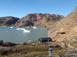
The Sermilik Research Station can be reached by commercial air carrier via Island to Kulusuk Airport (Greenland Air or charter flights) followed by a helicopter flight to Tasiilaq. From Tasiilaq to the station a boat or a helicopter charter is recommended depending on the weather, snow, or ice conditions, and the amount of luggage/cargo. It is also possible to reach the station after a 15-20 km hike. It is highly recommended to book favourable air tickets half a year in advance and to plan at least two travel days to reach Sermilik Station from Europe.

Member of: