Address

Litla Skarð Field Station
c/o Hlynur Óskarsson
Agricultural University of Iceland
Hvanneyri
311 Borgarnes
Iceland

Station manager

Hlynur Óskarsson
E-mail: hlynur@lbhi.is

Contact Station

Phone: +354-433-5000

www.ust.is/litla_skard

Station Features

Opening year: 1996 Status: Open
  • Type of station: Station
  • Operational period – year-round or Month A to Month B: Year-round
  • Name of station owner: Iceland Forest Service
  • Type of owner: Government
  • Name of managing institution: Agricultural University of Iceland and Icelandic Meteorological Office
  • Managing Institution Country: Iceland
  • Station owner country: Iceland
  • Partner institution: No
  • Station latitude: 64,72675556
  • Station longitude: -21,62971111
  • Country (station location): Iceland
  • Altitude of station: 115 m a.s.l
  • Min. altitude within study area: 115 m a.s.l
  • Max. altitude within study area: 229 m a.s.l
  • Nearest town/settlement: Borgarnes
  • Distance to nearest town/settlement: 25 km
  • Number of residents in nearest town: 2000
  • Distance to nearest research station: 93 km
  • Maps available at station: Map (1:250 000), aerial image, SPOT satellite image, Google Earth with low resolution
  • Climate zone: Low Arctic
  • Period of measurments for climate data below [year to year]: 15
  • Mean annual temperature: 3,1 °C
  • Mean temperature in February: -1,8 °C
  • Mean temperature in July: 10,8 °C
  • Precipitation type: Snow, Rain
  • Lake ice break up: May, June
  • Dominant wind direction: Northeast
  • Mean annual wind speed: 4,2 m/s
  • Maximum wind speed (absolute): 33,5 m/s
  • Landscape features Mountains, Valleys, Lake
  • Permafrost zone None
  • Vegetation zone Tree line, Polar desert/Semi-desert, Shrub tundra, Gramminoid tundra, Peatlands, Wetlands, Evergreen forest

Facilities

  • Area under roof: 0 m²
  • Max. number of visitors at a time : 6
  • Showers: Yes
  • Laundry facilities: Yes
  • Power supply – period (from ‘hour’ to ‘hour’ or 24 hours): 24 Hours
  • Power supply - plug type C, F
  • Logistics area: 0 m²
  • Conference room capacity: 0
  • Means of transportation to/from station Car
  • Airstrip (Length × Width) :
  • Number of staff peak season/summer: 0
  • Number of staff off season/winter: 0
  • Laboratory area: 40 m²
  • Field to station Mobile phone
  • Station to outside world Mobile phone, Internet
  • IT Infrastructure Wifi, Computers, Printer
  • Distance to hospital (estimated time – hours): 110

Science

  • Transnational Access: No
  • Remote Access: No
  • INTERACT Virtual Access: No
  • Permitting issues categories
    • Permits required for access to the station
    • Permits required for studies
  • Partner institutions (involved in the operation of the station)
    • Partner institution
  • Climate
    • Snow
    • Rain
    • Hail
  • Housing and accomodation
    • Showers
    • Laundry facilities
    • A
    • B
    • C
    • D
    • E
    • F
    • G
    • H
    • I
    • J
    • K
    • L
    • M
    • N
    • O
    • Municipal grid
    • Diesel/oil/gas
    • Wood
    • Solar
    • Wind
    • Water
    • Geothermal
    • Biofuel
    • Other
  • Logistics
    • Electrical and IT technologies
    • Mechanical
    • Metal
    • Wood
    • Plexiglas
    • Other
    • Walk
    • None
    • Tracked vehicle
    • Truck
    • SUV (4x4)
    • Car
    • ATV
    • Zodiac
    • Snowmobile
    • Open boat/Dhinghy
    • Closed boat
    • Bicycles
    • Amphibie vehicle
    • Ski
    • Other
    • Snow shoes
    • KickSledges
    • Other
    • Ski
    • Snowmobile
    • Boat
    • Car
    • Tracked vehicle
    • Truck
    • SUV (4x4)
    • Bus
    • Train
    • Airstrip
    • Scheduled flight
    • Chartered plane/helicopter
    • Helipad
    • Other
    • None
    • Harbour/port
    • Warf/pier
    • Pontoon/float bridge
    • Barges
    • Beach
  • Aircraft landing facilities
    • Helipad
  • Features in the facility area
    • Permanent snowpatches
    • Mountain
    • Valley
    • Lake
    • River
    • Shoreline
    • Tree line
    • Polar deserts/semi-deserts
    • Shrub tundra
    • Gramminoid tundra
    • Forest tundra
    • Peatlands
    • Wetlands
    • Palsa mires
    • Deciduous forest
    • Evergreen forest
    • Human settlements or resource use in the area
    • Arable land
    • Other
  • Main science disciplines
    • Astronomy
    • Atmospheric sciences
    • Cryology
    • Geology
    • Hydrology
    • Limnic biology
    • Marine biology
    • Terrestrial biology
    • Human biology
    • Anthropology
    • Archaeology
    • Sociology
    • Climate change
    • Environmental science (incl. pollution)
    • Oceanography
    • Agriculture
    • Animal husbandry
    • Fisheries
    • Forestry
    • Hunting
    • Tourism
  • Workshop facilities
    • Metal workshop
    • Wood workshop
    • Plexiglas workshop
    • Staff available to assist with constructions
  • Communication
    • Telephone
    • Satellite phone
    • VHF
    • E-mail
    • Internet
    • Computer
    • Printer
    • Scanner
    • Fax
  • Meteorology
    • Air temperature
    • Air humidity
    • Air pressure
    • Wind velocity
    • Wind direction
    • Precipitation
  • Energy balance and radiation
    • Energy balance
    • Short wave incoming
    • Short wave outgoing
    • Long wave incoming
    • Long wave outgoing
    • Net radiation
    • UV-B
    • Multi-spectral
    • Cloud cover/hours of sunshine
  • Hydrology/Limnology
    • River water discharge/water level
    • Lake water level
    • Water balance
    • Water temperature
    • Lake ice cover (formation/breakup/thickness)
    • Suspended sediment discharge
    • Organic matter discharge
    • PAR (Photosyntetically Active Radiation)/secchi depth
    • Water chemistry
  • Vegetation
    • Flowering phenology
    • Amount of flowering
    • NDVI (plot/transect)
    • Landscape NDVI (from satellite images)
    • Vascular plant community composition
    • Bryophyte community composition
    • Lichen community composition
    • Fungi community composition
    • Berry production
    • Aerobiological monitoring (pollen, spores, etc.)
    • Species list (community composition)
  • Birds
    • Abundance
    • Distribution
    • Phenology
    • Breeding birds
    • Nest initiation phenology
    • Nest predation rates
    • Species list (community composition)
  • Landscape and environment
    • Mountains
    • Nunataks
    • Volcano/crater
    • Lava fields
    • Plateaus
    • Moraines
    • Valleys
    • Homothermic Springs
    • Lake
    • Thermokarst lake
    • River
    • Delta/estuarie
    • Fjord
    • Continuous
    • Sea
    • Discontinuous
    • Beach
    • Sporadic
    • Rocky shores
    • Pingos/ice lenses
    • Sea cliffs
    • Other (text)
    • Palsa mires
    • None
    • Ice Caps
    • Glaciers
    • Permanent snow patches
    • None
    • Tree line
    • Polar desert/Semi-desert
    • Gramminoid tundra
    • Shrub tundra
    • Forest tundra
    • Wetlands
    • Peatlands/mires
    • Salt marshes/lagoons
    • Heath
    • Grassland
    • Deciduous forest
    • Evergreen forest
    • Terrestrial carnivores
    • Alpine heath
    • Ungulates
    • Hares
    • Other (text)
    • Rodents
    • Bird colonies
    • Polar bear
    • Whales
    • Seals
    • Fish
    • Settlement
    • Fishing
    • Hunting
    • Forestry
    • Agriculture
    • Tourism
    • Animal husbandry
    • Leisure activities
  • Laboratory
    • Freezer < -80
    • Freezer -40 - -10
    • Fridge
    • Microscopes
    • Basic laboratory equipment
    • Advanced laboratory equipment
    • Basic chemical reagents
    • Analytical instrumentation
    • Other
    • Laboratory available in nearby town/settlement
  • Communication and IT
    • Mobile phone
    • VHF
    • Satellite phone
    • Other
    • Satellite phone
    • Mobile phone
    • Internet
    • Other
    • Wireless transfer of data from field site to station
    • Wifi
    • Computers
    • Printer
    • Data storage
    • Statistical tools
    • GIS tools
    • Other
  • Medical facilities
    • Medical facilities
    • Basic
    • Medium
    • Extensive
    • Dental
    • Surgery
    • Other
    • No
    • In peak season
    • When open

Station name and owner

Litla-Skarð; is not a typical research station but a bio-monitoring site. The site is operated jointly by the Agricultural University of Iceland, the Icelandic Institute of Natural History, the Icelandic Meteorological Office, the Environmental and Food Agency of Iceland, and the Iceland Forest Service.

Location

The Litla-Skarð; bio-monitoring area is located in the lowlands of western Iceland (64°43'N, 21°37'W), about 38 km from the shore-line and 100 km north of Reykjavik.

Climate data

Grey colours are WMO Climate Normals including maximum and minimum values. Blue colours are individual years.

Climate data for the stations where extracted via Copernicus Climate Data Store, from the global gridded reanalysis product: ERA5 monthly averaged data on single levels from 1940 to present. Description and source code: Roemer J.K. 2023. https://doi.org/10.5281/zenodo.10214922 Data Source: Hersbach et al. 2023. Copernicus Climate Change Service (C3S) Climate Data Store (CDS), https://doi.org/10.24381/cds.f17050d7

Biodiversity and natural environment

The Litla-Skarð area exhibits birch shrubs, moss heaths, sedge mires, grassland as well as, sparsely vegetated fell fields. Also a small lake is found within the area. In total, 101 vascular plant species and 19 moss species have been recorded at the site. Birds dominate the vertebrate fauna with 22 species recorded in the area. Most notable of these are whooper swans (<em>Cygnus cygnus</em>), great northern divers (<em>Gavia immer</em>), and redwings (<em>Turdus iliacus</em>) in summer; snow bunting (<em>Plectrophenax nivalis</em>) in winter and raven (<em>Corvus corax</em>) and ptarmigan (<em>Lagopus muta</em>) year around. Three species of mammals occur at the site: Arctic fox (<em>Alopex lagopus</em>), American mink (<em>Mustela vison</em>), and wood mouse (<em>Apodemus sylvaticus</em>). Two species of fish occur in the lake: three-spined stickleback (<em>Gasterosteus aculeatus</em>) and brown trout (<em>Salmo trutta</em>).

History and facilities

The Litla-Skarð site was designated as a bio-monitoring area in 1996. Litla-Skarð is an old, lowland farm. The site is now owned by the Iceland Forest Service. In the past most of the area was used for grazing livestock, mainly sheep. The site has not been grazed since 1985. Afforestation at the site is very limited and disturbance level from human activities is low. The total land area of the Litla-Skar&eth; bio-monitoring area is 3 km<sup>2</sup> with an elevation of 60-230 m a.s.l. At Litla-Skar&eth; there are no research buildings or laboratories, and permanent staff is not located at the site. However, accommodation and laboratory space are available at the campus of the Agricultural University of Iceland in Hvanneyri, 27 km away from the site.

General research and databases

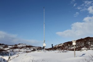
Litla-Skarð is a national site for the International Cooperative Program on Integrated Monitoring of Air Pollution Effects on Ecosystems (ICP IM). The main research emphasis till now has been on chemistry of precipitation, climate, and hydrology. A vegetation inventory has been carried out at the site, and the main vegetation and soil types have been mapped. The research is mostly confined to a 560000 m<sup>2</sup> catchment area. Automated weather and hydrological stations were set up at the site in 2000. Existing data bases include climatic records, data on catchment hydrology and water chemistry, as well as limited biological records.

Station Monitoring

Human dimension

Before the Litla-Skarð area was established as a research and monitoring site in 1996, farmsteads and sheep grazing dominated the land-use. Currently there are no farms in the area and domestic grazing animals have been absent for over 20 years.

Access

Litla-Skarð is reached by car throughout the year. It is located by the main central highway, c. 100 km from Reykjavik. Keflavik International Airport is situated about two hours drive from the site.

Member of: