Address

UK Centre for Ecology and Hydrology (UKCEH )
Bush Estate
Penicuik, Edinburgh, Midlothian
EH26 0QB
Scotland

Station manager

Christopher Andrews
E-mail: chan@ceh.ac.uk

Contact Station

Phone: +44 (0)131 445 4343

http://www.ecn.ac.uk/sites/site/terr/cairngorms

Station Features

Opening year: 1998 Status: Open
  • Type of station: Station
  • Operational period – year-round or Month A to Month B: Year-round
  • Name of station owner: NatureScot
  • Type of owner: Government
  • Name of managing institution: UK Center for Ecology and Hydrology
  • Managing Institution Country: United Kingdom
  • Station owner country: United Kingdom
  • Partner institution: No
  • Station latitude: 57,11500000
  • Station longitude: -3,83194444
  • Country (station location): United Kingdom
  • Altitude of station: 700 m a.s.l
  • Min. altitude within study area: 350 m a.s.l
  • Max. altitude within study area: 1111 m a.s.l
  • Nearest town/settlement: Aviemore
  • Distance to nearest town/settlement: 10 km
  • Number of residents in nearest town: 2500
  • Distance to nearest research station: 580 km
  • Maps available at station: Map 1:250 000, aerial image, satellite image, Google Earth with low resolution
  • Climate zone: Alpine
  • Climate zone: Boreal
  • Period of measurments for climate data below [year to year]: Since 1998
  • Mean annual temperature: 4,5 °C
  • Mean temperature in February: -0,1 °C
  • Mean temperature in July: 10,4 °C
  • Min. Temp. (absolute) - date: Thursday, 01 March 2018
  • Min. Temp. (absolute): -11,2 °C
  • Max. Temp. (absolute) - date: Tuesday, 28 June 2022
  • Max. Temp. (absolute): 27,42 °C
  • Precipitation type: Rain
  • Snow free period (month to month): April-November
  • Dominant wind direction: Southwest
  • Mean annual wind speed: 7,9 m/s
  • Date of maximum wind speed: Monday, 11 February 2013
  • Maximum wind speed (absolute): 55 m/s
  • Landscape features Mountains, Plateaus, Valleys, River
  • Permafrost zone None
  • Snow and ice on land None
  • Vegetation zone Tree line, Peatlands, Evergreen forest, Alpine heath
  • Wildlife Ungulates
  • Human use Tourism

Facilities

  • Area under roof: 0 m²
  • Max. number of visitors at a time : 80
  • Showers: No
  • Laundry facilities: No
  • Power supply - plug type G
  • Means of transportation to/from station Walk, Car
  • Airstrip (Length × Width) :
  • Number of staff peak season/summer: 2
  • Number of staff off season/winter: 2
  • Staff able to assist (fieldwork): Yes - at a cost
  • Staff able to assist (workshops): Yes - at a cost
  • Compulsory safety equipment GPS, Other
  • Recommended safety equipment PLB
  • Field power supply available at station: No
  • Laboratory equipment Freezer < -80, Fridge, Advanced laboratory equipment
  • Field to station Mobile phone
  • Station to outside world Mobile phone
  • Wireless transfer of data from field site to station: Yes
  • Distance to hospital (estimated time – hours): 10

Science

  • Transnational Access: Yes
  • Remote Access: Yes
  • INTERACT Virtual Access: No
  • Permitting issues categories
    • Permits required for access to the station
    • Permits required for studies
  • Partner institutions (involved in the operation of the station)
    • Partner institution
  • Climate
    • Snow
    • Rain
    • Hail
  • Housing and accomodation
    • Showers
    • Laundry facilities
    • A
    • B
    • C
    • D
    • E
    • F
    • G
    • H
    • I
    • J
    • K
    • L
    • M
    • N
    • O
    • Municipal grid
    • Diesel/oil/gas
    • Wood
    • Solar
    • Wind
    • Water
    • Geothermal
    • Biofuel
    • Other
  • Logistics
    • Electrical and IT technologies
    • Mechanical
    • Metal
    • Wood
    • Plexiglas
    • Other
    • Walk
    • None
    • Tracked vehicle
    • Truck
    • SUV (4x4)
    • Car
    • ATV
    • Zodiac
    • Snowmobile
    • Open boat/Dhinghy
    • Closed boat
    • Bicycles
    • Amphibie vehicle
    • Ski
    • Other
    • Snow shoes
    • KickSledges
    • Other
    • Ski
    • Snowmobile
    • Boat
    • Car
    • Tracked vehicle
    • Truck
    • SUV (4x4)
    • Bus
    • Train
    • Airstrip
    • Scheduled flight
    • Chartered plane/helicopter
    • Helipad
    • Other
    • None
    • Harbour/port
    • Warf/pier
    • Pontoon/float bridge
    • Barges
    • Beach
  • Aircraft landing facilities
    • Helipad
  • Features in the facility area
    • Permanent snowpatches
    • Mountain
    • Valley
    • Lake
    • River
    • Shoreline
    • Tree line
    • Polar deserts/semi-deserts
    • Shrub tundra
    • Gramminoid tundra
    • Forest tundra
    • Peatlands
    • Wetlands
    • Palsa mires
    • Deciduous forest
    • Evergreen forest
    • Human settlements or resource use in the area
    • Arable land
    • Other
  • Main science disciplines
    • Astronomy
    • Atmospheric sciences
    • Cryology
    • Geology
    • Hydrology
    • Limnic biology
    • Marine biology
    • Terrestrial biology
    • Human biology
    • Anthropology
    • Archaeology
    • Sociology
    • Climate change
    • Environmental science (incl. pollution)
    • Oceanography
    • Agriculture
    • Animal husbandry
    • Fisheries
    • Forestry
    • Hunting
    • Tourism
  • Workshop facilities
    • Metal workshop
    • Wood workshop
    • Plexiglas workshop
    • Staff available to assist with constructions
  • Communication
    • Telephone
    • Satellite phone
    • VHF
    • E-mail
    • Internet
    • Computer
    • Printer
    • Scanner
    • Fax
  • Meteorology
    • Air temperature
    • Air humidity
    • Air pressure
    • Wind velocity
    • Wind direction
    • Precipitation
  • Energy balance and radiation
    • Energy balance
    • Short wave incoming
    • Short wave outgoing
    • Long wave incoming
    • Long wave outgoing
    • Net radiation
    • UV-B
    • Multi-spectral
    • Cloud cover/hours of sunshine
  • Sub-surface characteristics
    • Ground surface temperature
    • Soil temperature
    • Soil moisture
    • Ground water table
    • Soil water chemistry
    • Active layer depth
    • Permafrost distribution
    • Permafrost thickness
    • Permafrost temperature
  • Snow characteristics
    • Snow depth
    • Snow cover
    • Snow density
    • Snow temperature
  • Hydrology/Limnology
    • River water discharge/water level
    • Lake water level
    • Water balance
    • Water temperature
    • Lake ice cover (formation/breakup/thickness)
    • Suspended sediment discharge
    • Organic matter discharge
    • PAR (Photosyntetically Active Radiation)/secchi depth
    • Water chemistry
  • Pollution
    • In air
    • In water
    • In soil
    • In snow/ice
    • Contaminants in species
  • Vegetation
    • Flowering phenology
    • Amount of flowering
    • NDVI (plot/transect)
    • Landscape NDVI (from satellite images)
    • Vascular plant community composition
    • Bryophyte community composition
    • Lichen community composition
    • Fungi community composition
    • Berry production
    • Aerobiological monitoring (pollen, spores, etc.)
    • Species list (community composition)
  • Arthropods
    • Abundance
    • Emergence phenology
    • Insect herbivory
    • Species list (community composition)
  • Birds
    • Abundance
    • Distribution
    • Phenology
    • Breeding birds
    • Nest initiation phenology
    • Nest predation rates
    • Species list (community composition)
  • Mammals
    • Mammal abundance
    • Mammal distribution
    • Mammal reproduction
    • Mortality
    • Predation
    • Physiology
    • Species list (community composition)
  • Diseases
    • Mammals
    • Birds
    • Fish
    • Vegetation
    • Other
  • Parasites
    • Mammals
    • Birds
    • Fish
    • Vegetation
    • Other
  • Socio-ecological issues (disturbance)
    • Number of visitors
    • Surface activities (e.g. removal of vegetation, organisms, soil samples, ATV traffic, manipulations)
    • Aircraft activities
    • Emissions/discharge energy consumption, spill water, waste, garbage, atmospheric emissions, etc.)
  • Landscape and environment
    • Mountains
    • Nunataks
    • Volcano/crater
    • Lava fields
    • Plateaus
    • Moraines
    • Valleys
    • Homothermic Springs
    • Lake
    • Thermokarst lake
    • River
    • Delta/estuarie
    • Fjord
    • Continuous
    • Sea
    • Discontinuous
    • Beach
    • Sporadic
    • Rocky shores
    • Pingos/ice lenses
    • Sea cliffs
    • Other (text)
    • Palsa mires
    • None
    • Ice Caps
    • Glaciers
    • Permanent snow patches
    • None
    • Tree line
    • Polar desert/Semi-desert
    • Gramminoid tundra
    • Shrub tundra
    • Forest tundra
    • Wetlands
    • Peatlands/mires
    • Salt marshes/lagoons
    • Heath
    • Grassland
    • Deciduous forest
    • Evergreen forest
    • Terrestrial carnivores
    • Alpine heath
    • Ungulates
    • Hares
    • Other (text)
    • Rodents
    • Bird colonies
    • Polar bear
    • Whales
    • Seals
    • Fish
    • Settlement
    • Fishing
    • Hunting
    • Forestry
    • Agriculture
    • Tourism
    • Animal husbandry
    • Leisure activities
  • Field equipment
    • PLB
    • VHF
    • HF
    • Satellite phone
    • Mobile phone
    • GPS
    • Weapon/rifle
    • Flare gun
    • Bearspray
    • PLB
    • First aid kit
    • Glacier rescue kit
    • VHF
    • Avalanche rescue kit
    • HF
    • Satellite phone
    • Overnight equipment
    • Other
    • Mobile phone
    • GPS
    • Weapon/rifle
    • Flare gun
    • Bearspray
    • PLB
    • First aid kit
    • Glacier rescue kit
    • VHF
    • Avalanche rescue kit
    • HF
    • Satellite phone
    • Overnight equipment
    • Other
    • Mobile phone
    • GPS
    • Weapon/rifle
    • Flare gun
    • Bearspray
    • Tent
    • First aid kit
    • Glacier rescue kit
    • Sleeping matress
    • Avalanche rescue kit
    • Sleeping bag
    • Cooking equipment and utensils
    • Overnight equipment
    • Other
    • Gas/alcohol for cooking
    • Field power supply available at station
  • Laboratory
    • Freezer < -80
    • Freezer -40 - -10
    • Fridge
    • Microscopes
    • Basic laboratory equipment
    • Advanced laboratory equipment
    • Basic chemical reagents
    • Analytical instrumentation
    • Other
    • Laboratory available in nearby town/settlement
  • Communication and IT
    • Mobile phone
    • VHF
    • Satellite phone
    • Other
    • Satellite phone
    • Mobile phone
    • Internet
    • Other
    • Wireless transfer of data from field site to station
    • Wifi
    • Computers
    • Printer
    • Data storage
    • Statistical tools
    • GIS tools
    • Other
  • Medical facilities
    • Medical facilities
    • Basic
    • Medium
    • Extensive
    • Dental
    • Surgery
    • Other
    • No
    • In peak season
    • When open

Station name and owner

The ECN Cairngorms site is owned by Scottish National Heritage, a Scottish government funded body that looks after Scotland's landscapes whilst research is managed by Centre for Ecology and Hydrology. ECN stands for the UK Environmental Change Network, and is the UK's long-term environmental monitoring and research programme. The ECN makes regular measurements of air, soil, water, and a range of animals and plants across a network of sites to determine how and why the natural environment is changing (see www.ecn.ac.uk for more information).

Location

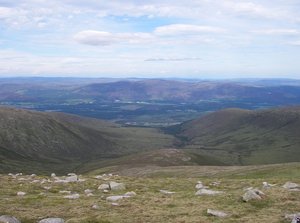
The ECN Cairngorms site is a north facing granite catchment overlain with peat situated in the Cairngorms Mountains of Scotland (57°07'N, 03°49'W), rising from about 350 m a.s.l. through the tree line at 500 m a.s.l. to the highest summit at 1111 m a.s.l. The catchment area is 10 km2. The site is part of the Invereshie and Inshriach National Nature &shy;Reserve, and forms part of the Cairngorms National Park.

Climate data

Grey colours are WMO Climate Normals including maximum and minimum values. Blue colours are individual years.

Climate data for the stations where extracted via Copernicus Climate Data Store, from the global gridded reanalysis product: ERA5 monthly averaged data on single levels from 1940 to present. Description and source code: Roemer J.K. 2023. https://doi.org/10.5281/zenodo.10214922 Data Source: Hersbach et al. 2023. Copernicus Climate Change Service (C3S) Climate Data Store (CDS), https://doi.org/10.24381/cds.f17050d7

Biodiversity and natural environment

The catchment is composed of a wide range of ecosystems from pine forest at low altitude, through bog communities on ground with impeded drainage, to alpine vegetation including moss and lichen heaths on the highest ground. The charismatic capercaillie, a member of the grouse family (IUCN Red listed), is found in the pine woods along with pine martin. Several species of deer can be found grazing a variety of habitats from the forests to the summits. The site has virtually no natural tree line due to past overgrazing but is now being extensively re-colonised by Pinus sylvestris.

History and facilities

From the middle of the nineteenth century the site was mainly used as deer forest, as part of a large sporting estate in private ownership (Invereshie Estate). It became part of the Cairngorms National Nature Reserve in 1954. Ecological and environmental research has been undertaken in the area since the early 1960s, and the site joined the Environmental Change Network of the UK in 1998. There are no buildings on the site, but accommodation for a small number of visitors can be arranged on site (camping), and there are local hotels and guest houses nearby.

General research and databases

Research on the site includes both terrestrial and freshwater environmental monitoring as part of the ECN and also as part of the Austrian GLORIA programme (www.gloria.ac.at), examining temperature effects on vegetation across Alpine Europe. Intensive hydrological and snow related research took place in the early 1990s. The Cairngorms area has been the focus of many land use change and tourism impact studies since c. the 1980s, and the data is being used in current ecosystem service research.

Station Monitoring

Human dimension

The research site is uninhabited and used for recreation; hiking, trekking, and mountain biking. Aviemore, the nearest town, has a population of around 2500 and became one of the first skiing resorts to be established in Scotland with the opening of the chairlift in 1961. The resort has since grown into the UK's most visited ski resort during the winter months. In 2013, the national park became the first Long-Term Social-Ecological Research (LTSER) platform in the UK, providing a platform for linking ecological, social and economic research.

Access

The research site is close to Aviemore, which has good rail and bus services to Edinburgh (approximately 3 hours) and Inverness (less than an hour). A full suite of laboratory facilities are available at the Centre for Ecology and Hydrology, Edinburgh (CEH) located 10 km south of Edinburgh.

Member of: