Address

Station address:
473 Kuururjuaq Street
Kangiqsualujjuaq, Qc
J0M 1N0

Station manager

Mickaél Lemay
E-mail: mickael.lemay@cen.ulaval.ca

Contact Station

Phone: +1 819-929-3319 ext. 227
E-mail: station@cen.ulaval.ca

http://www.cen.ulaval.ca/en/station.php?id=505176&nm=kangiq

Station Features

Opening year: 2018 Status: Open
  • Type of station: Station
  • Operational period – year-round or Month A to Month B: Year-round
  • Name of station owner: Centre d'études nordiques (CEN at Université Laval; www.cen.ulaval.ca)
  • Type of owner: Research institution
  • Name of managing institution: Centre d'études nordiques (CEN at Université Laval; www.cen.ulaval.ca)
  • Managing Institution Country: Canada
  • Station owner country: Canada
  • Partner institution: Yes
  • Partner institution name: Northern Village of Kangiqsualujjuaq
  • Station latitude: 58,70000000
  • Station longitude: -65,93333333
  • Country (station location): Canada
  • Altitude of station: 28 m a.s.l
  • Min. altitude within study area: 0 m a.s.l
  • Max. altitude within study area: 1646 m a.s.l
  • Nearest town/settlement: Kangiqsualujjuaq
  • Distance to nearest town/settlement: 0 km
  • Number of residents in nearest town: 875
  • Distance to nearest research station: 570 km
  • Maps available at station: https://www.google.com/maps/place/Kangiqsualujjuaq,+QC/@58.6983905,-66.0521642,12z/data=!3m1!4b1!4m5!3m4!1s0x4c47c0071c3fcc53:0x86ca24c53bfa9a4b!8m2!3d58.7101548!4d-65.995116
  • Climate zone: Sub-Arctic
  • Period of measurments for climate data below [year to year]: 1987
  • Mean annual temperature: -5,7 °C
  • Mean temperature in February: -20,33 °C
  • Mean temperature in July: 10,6 °C
  • Precipitation type: Snow, Rain
  • Sea ice break up: June, July
  • Dominant wind direction: South
  • Mean annual wind speed: 5,3 m/s
  • Maximum wind speed (absolute): 23,61 m/s
  • Landscape features Mountains, Valleys, Lake, River, Sea
  • Permafrost zone Discontinuous
  • Snow and ice on land Permanent snow patches
  • Vegetation zone Tree line, Shrub tundra, Forest tundra, Peatlands, Wetlands, Deciduous forest, Evergreen forest

Facilities

  • Area under roof: 128,3 m²
  • Max. number of visitors at a time : 6
  • Showers: Yes
  • Laundry facilities: Yes
  • Power supply – period (from ‘hour’ to ‘hour’ or 24 hours): 24 Hours
  • Power supply - plug type A, B
  • Logistics area: 25 m²
  • Air transport landing facilities at station Airstrip
  • Airstrip (Length × Width) : 1073 × 30 m
  • Transport on land - at station ATV, Other
  • Water landing facilities Warf/pier
  • Number of staff peak season/summer: 1
  • Number of staff off season/winter: 1
  • Compulsory safety equipment PLB, Satellite phone, Other
  • Recommended safety equipment PLB, Satellite phone, Weapon/rifle, Other
  • Laboratory area: 26 m²
  • Field to station Mobile phone
  • Station to outside world Mobile phone, Internet
  • IT Infrastructure Wifi
  • Medical facilities: Yes
  • Medical capability Medium
  • Staff with medical training/doctor When open
  • Distance to hospital (estimated time – hours): 0

Science

  • Transnational Access: No
  • Remote Access: No
  • INTERACT Virtual Access: No
  • Partner institutions (involved in the operation of the station)
    • Partner institution
  • Climate
    • Snow
    • Rain
    • Hail
  • Geology/Geomorphology
    • Quaternary geology
    • Sedimentology
    • Bedrock geology
    • Erosion
  • Hydrology/Limnology
    • River water discharge/water level
    • Lake water level
    • Water balance
    • Water temperature
    • Lake ice cover (formation/breakup/thickness)
    • Suspended sediment discharge
    • Organic matter discharge
    • PAR (Photosyntetically Active Radiation)/secchi depth
    • Water chemistry
  • Vegetation
    • Flowering phenology
    • Amount of flowering
    • NDVI (plot/transect)
    • Landscape NDVI (from satellite images)
    • Vascular plant community composition
    • Bryophyte community composition
    • Lichen community composition
    • Fungi community composition
    • Berry production
    • Aerobiological monitoring (pollen, spores, etc.)
    • Species list (community composition)
  • Lake ecology
    • Phytoplankton (including chlorophyll)
    • Zooplankton
    • Vegetation
    • Fish
    • Invertebrates
    • Species list (community composition)
  • Meteorology
    • Air temperature
    • Air humidity
    • Air pressure
    • Wind velocity
    • Wind direction
    • Precipitation
  • Sub-surface characteristics
    • Ground surface temperature
    • Soil temperature
    • Soil moisture
    • Ground water table
    • Soil water chemistry
    • Active layer depth
    • Permafrost distribution
    • Permafrost thickness
    • Permafrost temperature
  • Genetics
    • Collection of genetic material
  • Features in the facility area
    • Permanent snowpatches
    • Mountain
    • Valley
    • Lake
    • River
    • Shoreline
    • Tree line
    • Polar deserts/semi-deserts
    • Shrub tundra
    • Gramminoid tundra
    • Forest tundra
    • Peatlands
    • Wetlands
    • Palsa mires
    • Deciduous forest
    • Evergreen forest
    • Human settlements or resource use in the area
    • Arable land
    • Other
  • Main science disciplines
    • Astronomy
    • Atmospheric sciences
    • Cryology
    • Geology
    • Hydrology
    • Limnic biology
    • Marine biology
    • Terrestrial biology
    • Human biology
    • Anthropology
    • Archaeology
    • Sociology
    • Climate change
    • Environmental science (incl. pollution)
    • Oceanography
    • Agriculture
    • Animal husbandry
    • Fisheries
    • Forestry
    • Hunting
    • Tourism
  • Housing and accomodation
    • Showers
    • Laundry facilities
    • A
    • B
    • C
    • D
    • E
    • F
    • G
    • H
    • I
    • J
    • K
    • L
    • M
    • N
    • O
    • Municipal grid
    • Diesel/oil/gas
    • Wood
    • Solar
    • Wind
    • Water
    • Geothermal
    • Biofuel
    • Other
  • Workshop facilities
    • Metal workshop
    • Wood workshop
    • Plexiglas workshop
    • Staff available to assist with constructions
  • Communication
    • Telephone
    • Satellite phone
    • VHF
    • E-mail
    • Internet
    • Computer
    • Printer
    • Scanner
    • Fax
  • Logistics
    • Electrical and IT technologies
    • Mechanical
    • Metal
    • Wood
    • Plexiglas
    • Other
    • Walk
    • None
    • Tracked vehicle
    • Truck
    • SUV (4x4)
    • Car
    • ATV
    • Zodiac
    • Snowmobile
    • Open boat/Dhinghy
    • Closed boat
    • Bicycles
    • Amphibie vehicle
    • Ski
    • Other
    • Snow shoes
    • KickSledges
    • Other
    • Ski
    • Snowmobile
    • Boat
    • Car
    • Tracked vehicle
    • Truck
    • SUV (4x4)
    • Bus
    • Train
    • Airstrip
    • Scheduled flight
    • Chartered plane/helicopter
    • Helipad
    • Other
    • None
    • Harbour/port
    • Warf/pier
    • Pontoon/float bridge
    • Barges
    • Beach
  • Aircraft landing facilities
    • Helipad
  • Permitting issues categories
    • Permits required for studies
    • Permits required for access to the station
  • Microbiology
    • Interstitial fauna
    • Species list (community composition)
  • Arthropods
    • Abundance
    • Emergence phenology
    • Insect herbivory
    • Species list (community composition)
  • Birds
    • Abundance
    • Distribution
    • Phenology
    • Breeding birds
    • Nest initiation phenology
    • Nest predation rates
    • Species list (community composition)
  • Mammals
    • Mammal abundance
    • Mammal distribution
    • Mammal reproduction
    • Mortality
    • Predation
    • Physiology
    • Species list (community composition)
  • Pollution
    • Pollution measurements in vegetation
    • Pollution measurements in water
    • Pollution measurements in mammals (body burdens, biomarkers)
    • Pollution measurements in birds (body burdens, biomarkers on both adults and offspring e.g. egg shell thinning, macro plastic in nests/in body)
  • Pollution
    • In air
    • In water
    • In soil
    • In snow/ice
    • Contaminants in species
  • Snow characteristics
    • Snow depth
    • Snow cover
    • Snow density
    • Snow temperature
  • Climate
    • Climate measurements
    • Energy balance
  • Landscape and environment
    • Mountains
    • Nunataks
    • Volcano/crater
    • Lava fields
    • Plateaus
    • Moraines
    • Valleys
    • Homothermic Springs
    • Lake
    • Thermokarst lake
    • River
    • Delta/estuarie
    • Fjord
    • Sea
    • Continuous
    • Discontinuous
    • Beach
    • Sporadic
    • Rocky shores
    • Pingos/ice lenses
    • Sea cliffs
    • Other (text)
    • Palsa mires
    • Ice Caps
    • None
    • Glaciers
    • Permanent snow patches
    • None
    • Tree line
    • Polar desert/Semi-desert
    • Gramminoid tundra
    • Shrub tundra
    • Forest tundra
    • Wetlands
    • Peatlands/mires
    • Salt marshes/lagoons
    • Heath
    • Grassland
    • Deciduous forest
    • Evergreen forest
    • Terrestrial carnivores
    • Alpine heath
    • Ungulates
    • Hares
    • Other (text)
    • Rodents
    • Bird colonies
    • Polar bear
    • Whales
    • Seals
    • Fish
    • Settlement
    • Fishing
    • Hunting
    • Forestry
    • Agriculture
    • Tourism
    • Animal husbandry
    • Leisure activities
  • Field equipment
    • PLB
    • VHF
    • HF
    • Satellite phone
    • Mobile phone
    • GPS
    • Weapon/rifle
    • Flare gun
    • Bearspray
    • PLB
    • First aid kit
    • Glacier rescue kit
    • VHF
    • Avalanche rescue kit
    • HF
    • Satellite phone
    • Overnight equipment
    • Other
    • Mobile phone
    • GPS
    • Weapon/rifle
    • Flare gun
    • Bearspray
    • PLB
    • First aid kit
    • Glacier rescue kit
    • VHF
    • Avalanche rescue kit
    • HF
    • Satellite phone
    • Overnight equipment
    • Other
    • Mobile phone
    • GPS
    • Weapon/rifle
    • Flare gun
    • Bearspray
    • Tent
    • First aid kit
    • Glacier rescue kit
    • Sleeping matress
    • Avalanche rescue kit
    • Sleeping bag
    • Cooking equipment and utensils
    • Overnight equipment
    • Other
    • Gas/alcohol for cooking
    • Field power supply available at station
  • Laboratory
    • Freezer < -80
    • Freezer -40 - -10
    • Fridge
    • Microscopes
    • Basic laboratory equipment
    • Advanced laboratory equipment
    • Basic chemical reagents
    • Analytical instrumentation
    • Other
    • Laboratory available in nearby town/settlement
  • Communication and IT
    • Mobile phone
    • VHF
    • Satellite phone
    • Other
    • Satellite phone
    • Mobile phone
    • Internet
    • Other
    • Wireless transfer of data from field site to station
    • Wifi
    • Computers
    • Printer
    • Data storage
    • Statistical tools
    • GIS tools
    • Other
  • Medical facilities
    • Medical facilities
    • Basic
    • Medium
    • Extensive
    • Dental
    • Surgery
    • Other
    • No
    • In peak season
    • When open

Station name and owner

CEN Kangiqsualujjuaq SUKUIJARVIK Research Station is owned and run by the Centre d'etudes nordiques (CEN: Centre for Northern Studies) at Université; Laval. The station is part of the CEN Network of research stations. The station is run in close collaboration with the community of Kangiqsualujjuaq and the Qiniqtiq Land Holding Corporation.

Location

The station is situated in the community of Kangiqsualujjuaq (population of 942 in 2016), on the shores of George River which flows into Ungava Bay, Nunavik, Quebec, Canada. This region is characterized by deep valleys shaped by glacier retreat and steep cliffs. Several remains from the last glaciation can be found here: trough valleys, cirques, morainic ridges, suspended valleys, etc. The village is the gateway to Kuururjuaq Park and the Torngat Mountains (Nunavik Provincial Parks). Ulittaniujalik Park, a second provincial park operated by Nunavik Parks, is currently being created. In the area is Mount Caubvick (D'Iberville), the highest peak in the province of Quebec culminating at 1646m.

Climate data

Grey colours are WMO Climate Normals including maximum and minimum values. Blue colours are individual years.

Climate data for the stations where extracted via Copernicus Climate Data Store, from the global gridded reanalysis product: ERA5 monthly averaged data on single levels from 1940 to present. Description and source code: Roemer J.K. 2023. https://doi.org/10.5281/zenodo.10214922 Data Source: Hersbach et al. 2023. Copernicus Climate Change Service (C3S) Climate Data Store (CDS), https://doi.org/10.24381/cds.f17050d7

Biodiversity and natural environment

The cold climate and topographic heterogeneity create a diverse landscape with tundra, forest tundra and boreal forest vegetation. The valley bottoms are ecologically rich, characterized by a rise of the boreal forest (with the presence of spruce, larch, birch, etc.) that contrasts with the bare areas of the region's slopes and peaks. In terms of wildlife, the distribution of species is closely linked to vegetation, relief and climate. A special feature of this area is the presence of the George River caribou herd and further from the village, the Torngat Mountains herd. Wolf, black bear, snowy owl and willow ptarmigan also inhabit this area. Atlantic salmon and Arctic char are numerous in the region's rivers. As for Ungava Bay and the rivers that flow into it, it represents an estuary rich in salmon, Arctic char, brook trout, beluga whales, and several seal species. The area is characterized with discontinuous permafrost.

History and facilities

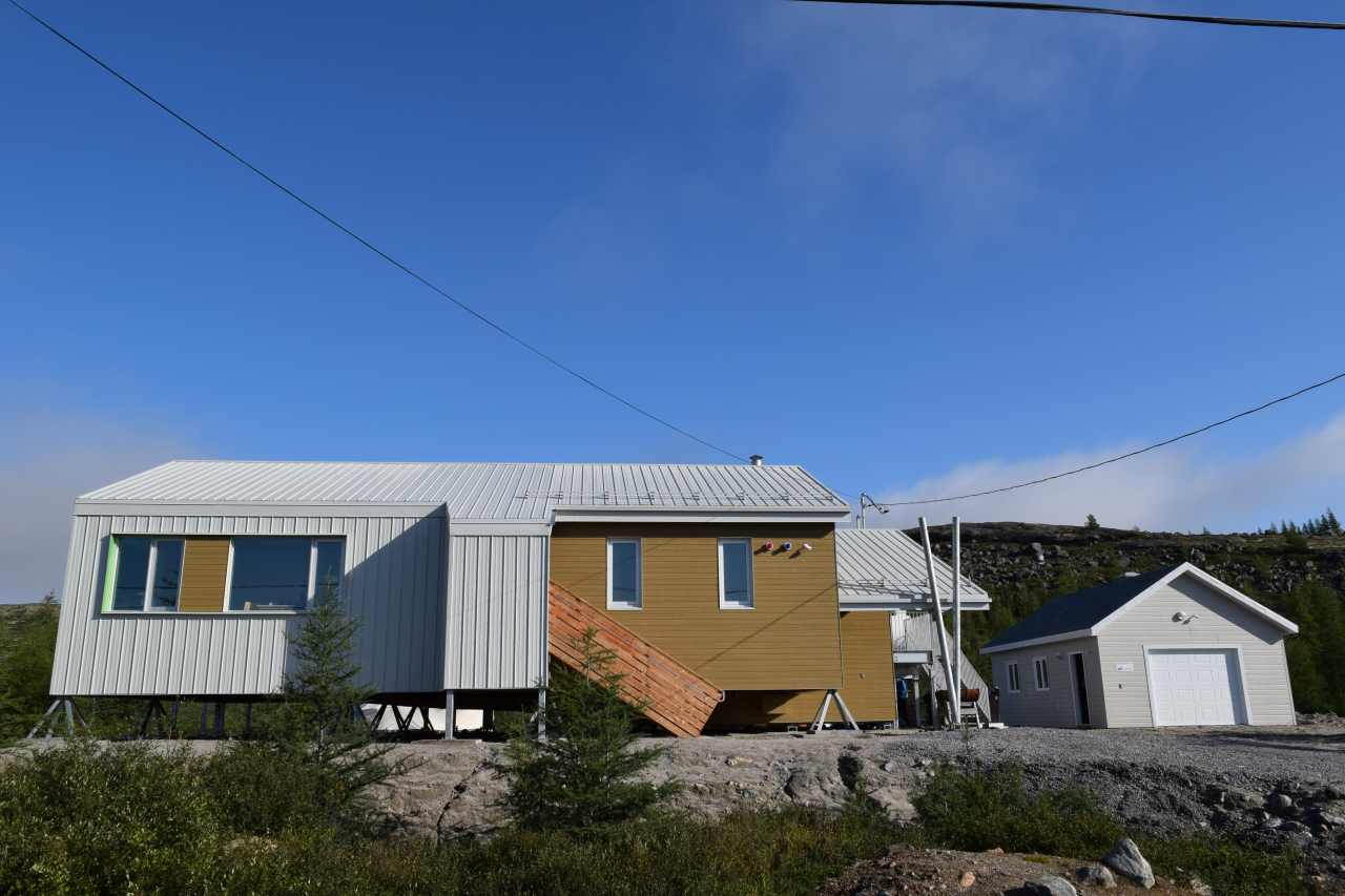
The station officially opened in the summer of 2018. It is open year-round and has 2 rooms, one with 1 bunk bed (2 beds) and one with two bunk beds (4 beds). The station also has one meeting room for about 25 persons, a kitchen, a sample manipulation room, and 2 bathrooms (one with shower and washer/dryer for residents). Power source is electrical, solar panels will be installed shortly. There is running water that is drinkable. Heating is with an oil furnace. Garbage is collected on a weekly basis, there are bins outside of the stations for this purpose. There is no recycling facility in the village. Chemical storage is not authorized. There is no fumehood, hence only mild chemicals can be used. All chemicals brought in must be brought out immediately. For sample preparation, there is an oven, a freezer (-80&deg;C), refrigerator, scales, some basic glassware, and centrifuge

General research and databases

<p>Past and current research focuses on permafrost, coastal geology and geomorphological characterization of the region. Other research areas cover caribou population dynamics, impacts of permafrost thawing in the context of climate warming; slope dynamics; wetland paleoecology; snow and ice dynamics; water quality and contamination; and plant community dynamics and northern plant response to climate change. Archaeological studies and community follow-up activities also take place in the area, such as Imalirijiit, a community-based environmental monitoring program and the Avativut project "Science in Nunavik, high school students learning in relation to their territory".</p> <p>CEN has been collecting extensive climate data since 1987 and currently operates four SILA climate stations. Seven thermistor cables were also installed to monitor permafrost temperature at various depths. <br />CEN's Nordicana D journal publishes data reports, facilitating the management of data sets generated by CEN. The following Nordicana D issue is available from Kangiqsualujjuaq: Sarrazin, D., Allard, M. 2018. Data from climate stations in the Kangiqsualujjuaq region of Nunavik, Quebec, Canada, v. 1.3 (1988-2017). Nordicana D14, doi: 10.5885/45264SL-AF7FDA53F9E44927. Visit the Nordicanca D site for a complete list of data series.</p>

Station Monitoring

Human dimension

The station is located directly within the limits of the village of Kangiqsualujjuaq which has a population of 942 inhabitants. Inuktitut, English and some French are spoken. As for the history, archaeological sites associated with Thule, Dorset and pre-Dorset populations have been identified in the Kangiqsualujjuaq area. The first traces of occupation are dated around 2350 BP. In 1838, the first trading post was established at the present site of the village by the Hudson's Bay Company. In 1959, the first Inuit co-op, the F&eacute;d&eacute;ration des coop&eacute;ratives du Nouveau-Qu&eacute;bec (FCNQ) was founded in Kangiqsualujjuaq. Until 1980, the village was known as George River or Port Nouveau-Qu&eacute;bec.

Access

<p>Daily access by commercial airline (Air Inuit) from Kuujjuaq. Kuujjuaq is accessible by commercial airline (Air Inuit, First Air) through Montreal, Ottawa and Quebec. The airport is only a few kilometres from the station. Every summer, two cargo ships allow shipping of heavy equipment and materials (May-June to August-September), though this requires advance planning. One ATV (1 passenger) and one side-by-side (6 passengers) can be rented at the station. Snowmobiles, trucks, canoes, and other ATV&rsquo;s can be rented in the village.</p> <p>No official research permit is required but local authorities must accept all research activities before they take place. You must prepare a letter and supporting documents (in plain language) and send them to the station manager, the Qiniqtiq Landholding Corporation and the Northern Village of Kangiqsualujjuaq. If you plan to work within the limits of Kuururjuaq Park, you must submit a research permit application many months in advance : http://www.nunavikparks.ca/en/research-requests&nbsp;&nbsp;&nbsp;</p>

Member of: