Address

Skalanes NHC,
710, Seyðisfjörður
Iceland

Station manager

Ólafur Örn Pétursson

Contact Station

Phone: +354 7797008
E-mail: skalanes@skalanes.com

www.skalanes.com

Station Features

Opening year: 2005 Status: Open
  • Type of station: Station
  • Operational period – year-round or Month A to Month B: Year-round
  • Name of station owner: Olafur Petursson
  • Type of owner: Private
  • Name of managing institution: Skalanes
  • Managing Institution Country: Iceland
  • Station owner country: Iceland
  • Partner institution: No
  • Station latitude: 65,29420755
  • Station longitude: -13,70558768
  • Country (station location): Iceland
  • Altitude of station: 15 m a.s.l
  • Min. altitude within study area: 1 m a.s.l
  • Max. altitude within study area: 923 m a.s.l
  • Nearest town/settlement: Seydisfjordur
  • Distance to nearest town/settlement: 17 km
  • Number of residents in nearest town: 650
  • Distance to nearest public transport facility (Airport, Ferry terminal, Train station, Bus station): 44 km
  • Distance to nearest research station: 160 km
  • Climate zone: Sub-Arctic
  • Period of measurments for climate data below [year to year]: 2017
  • Mean annual temperature: 5,3 °C
  • Mean temperature in February: 2,3 °C
  • Mean temperature in July: 9,8 °C
  • Precipitation type: Snow, Rain, Hail
  • Landscape features Mountains, Valleys, River, Sea
  • Permafrost zone None
  • Snow and ice on land Permanent snow patches
  • Vegetation zone Shrub tundra, Gramminoid tundra, Peatlands, Wetlands

Facilities

  • Area under roof: 350 m²
  • Max. number of visitors at a time : 30
  • Showers: Yes
  • Laundry facilities: Yes
  • Power supply – period (from ‘hour’ to ‘hour’ or 24 hours): 24 Hours
  • Power supply - plug type C, F
  • Logistics area: 400 m²
  • Workshops Metal, Wood
  • Means of transportation to/from station Car
  • Transport on water - at station Zodiac
  • Number of staff peak season/summer: 5
  • Number of staff off season/winter: 2
  • Staff able to assist (workshops): Yes - at a cost
  • Compulsory safety equipment VHF, Other
  • Field to station Mobile phone, VHF
  • Station to outside world Mobile phone, Internet
  • IT Infrastructure Wifi
  • Distance to hospital (estimated time – hours): 17

Science

  • Transnational Access: No
  • Remote Access: No
  • INTERACT Virtual Access: No
  • Climate
    • Snow
    • Rain
    • Hail
  • Features in the facility area
    • Permanent snowpatches
    • Mountain
    • Valley
    • Lake
    • River
    • Shoreline
    • Tree line
    • Polar deserts/semi-deserts
    • Shrub tundra
    • Gramminoid tundra
    • Forest tundra
    • Peatlands
    • Wetlands
    • Palsa mires
    • Deciduous forest
    • Evergreen forest
    • Human settlements or resource use in the area
    • Arable land
    • Other
  • Main science disciplines
    • Astronomy
    • Atmospheric sciences
    • Cryology
    • Geology
    • Hydrology
    • Limnic biology
    • Marine biology
    • Terrestrial biology
    • Human biology
    • Anthropology
    • Archaeology
    • Sociology
    • Climate change
    • Environmental science (incl. pollution)
    • Oceanography
    • Agriculture
    • Animal husbandry
    • Fisheries
    • Forestry
    • Hunting
    • Tourism
  • Housing and accomodation
    • Showers
    • Laundry facilities
    • A
    • B
    • C
    • D
    • E
    • F
    • G
    • H
    • I
    • J
    • K
    • L
    • M
    • N
    • O
    • Municipal grid
    • Diesel/oil/gas
    • Wood
    • Solar
    • Wind
    • Water
    • Geothermal
    • Biofuel
    • Other
  • Communication
    • Telephone
    • Satellite phone
    • VHF
    • E-mail
    • Internet
    • Computer
    • Printer
    • Scanner
    • Fax
  • Logistics
    • Electrical and IT technologies
    • Mechanical
    • Metal
    • Wood
    • Plexiglas
    • Other
    • Walk
    • None
    • Tracked vehicle
    • Truck
    • SUV (4x4)
    • Car
    • Zodiac
    • ATV
    • Snowmobile
    • Open boat/Dhinghy
    • Closed boat
    • Bicycles
    • Amphibie vehicle
    • Ski
    • Other
    • Snow shoes
    • KickSledges
    • Other
    • Ski
    • Snowmobile
    • Boat
    • Car
    • Tracked vehicle
    • Truck
    • SUV (4x4)
    • Bus
    • Train
    • Airstrip
    • Scheduled flight
    • Chartered plane/helicopter
    • Helipad
    • Other
    • None
    • Harbour/port
    • Warf/pier
    • Pontoon/float bridge
    • Barges
    • Beach
  • Aircraft landing facilities
    • Helipad
  • Permitting issues categories
    • Permits required for access to the station
    • Permits required for studies
  • Geology/Geomorphology
    • Quaternary geology
    • Sedimentology
    • Bedrock geology
    • Erosion
  • Hydrology/Limnology
    • River water discharge/water level
    • Lake water level
    • Water balance
    • Water temperature
    • Lake ice cover (formation/breakup/thickness)
    • Suspended sediment discharge
    • Organic matter discharge
    • PAR (Photosyntetically Active Radiation)/secchi depth
    • Water chemistry
  • Vegetation
    • Flowering phenology
    • Amount of flowering
    • NDVI (plot/transect)
    • Landscape NDVI (from satellite images)
    • Vascular plant community composition
    • Bryophyte community composition
    • Lichen community composition
    • Fungi community composition
    • Berry production
    • Aerobiological monitoring (pollen, spores, etc.)
    • Species list (community composition)
  • Arthropods
    • Abundance
    • Emergence phenology
    • Insect herbivory
    • Species list (community composition)
  • Birds
    • Abundance
    • Distribution
    • Phenology
    • Breeding birds
    • Nest initiation phenology
    • Nest predation rates
    • Species list (community composition)
  • Pollution
    • Pollution measurements in vegetation
    • Pollution measurements in water
    • Pollution measurements in mammals (body burdens, biomarkers)
    • Pollution measurements in birds (body burdens, biomarkers on both adults and offspring e.g. egg shell thinning, macro plastic in nests/in body)
  • Socio-ecological issues (disturbance)
    • Number of visitors
    • Surface activities (e.g. removal of vegetation, organisms, soil samples, ATV traffic, manipulations)
    • Aircraft activities
    • Emissions/discharge energy consumption, spill water, waste, garbage, atmospheric emissions, etc.)
  • Partner institutions (involved in the operation of the station)
    • Partner institution
  • Landscape and environment
    • Mountains
    • Nunataks
    • Volcano/crater
    • Lava fields
    • Plateaus
    • Moraines
    • Valleys
    • Homothermic Springs
    • Lake
    • Thermokarst lake
    • River
    • Delta/estuarie
    • Fjord
    • Sea
    • Continuous
    • Discontinuous
    • Beach
    • Sporadic
    • Rocky shores
    • Pingos/ice lenses
    • Sea cliffs
    • Other (text)
    • Palsa mires
    • None
    • Ice Caps
    • Glaciers
    • Permanent snow patches
    • None
    • Tree line
    • Polar desert/Semi-desert
    • Gramminoid tundra
    • Shrub tundra
    • Forest tundra
    • Wetlands
    • Peatlands/mires
    • Salt marshes/lagoons
    • Heath
    • Grassland
    • Deciduous forest
    • Evergreen forest
    • Terrestrial carnivores
    • Alpine heath
    • Ungulates
    • Hares
    • Other (text)
    • Rodents
    • Bird colonies
    • Polar bear
    • Whales
    • Seals
    • Fish
    • Settlement
    • Fishing
    • Hunting
    • Forestry
    • Agriculture
    • Tourism
    • Animal husbandry
    • Leisure activities
  • Field equipment
    • PLB
    • VHF
    • HF
    • Satellite phone
    • Mobile phone
    • GPS
    • Weapon/rifle
    • Flare gun
    • Bearspray
    • PLB
    • First aid kit
    • Glacier rescue kit
    • VHF
    • Avalanche rescue kit
    • HF
    • Satellite phone
    • Overnight equipment
    • Other
    • Mobile phone
    • GPS
    • Weapon/rifle
    • Flare gun
    • Bearspray
    • PLB
    • First aid kit
    • Glacier rescue kit
    • VHF
    • Avalanche rescue kit
    • HF
    • Satellite phone
    • Overnight equipment
    • Other
    • Mobile phone
    • GPS
    • Weapon/rifle
    • Flare gun
    • Bearspray
    • Tent
    • First aid kit
    • Glacier rescue kit
    • Sleeping matress
    • Avalanche rescue kit
    • Sleeping bag
    • Cooking equipment and utensils
    • Overnight equipment
    • Other
    • Gas/alcohol for cooking
    • Field power supply available at station
  • Communication and IT
    • Mobile phone
    • VHF
    • Satellite phone
    • Other
    • Satellite phone
    • Mobile phone
    • Internet
    • Other
    • Wireless transfer of data from field site to station
    • Wifi
    • Computers
    • Printer
    • Data storage
    • Statistical tools
    • GIS tools
    • Other
  • Medical facilities
    • Medical facilities
    • Basic
    • Medium
    • Extensive
    • Dental
    • Surgery
    • Other
    • No
    • In peak season
    • When open

Station name and owner

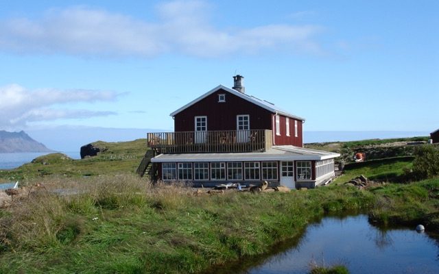
Skálanes Nature and Heritage Center is an independent research station directed and owned by Ólafur Örn Pétursson.

Location

Skálanes is located on the east coast of Iceland at the bay of the remote fjord, Seyðisfjörður. Here, skálanes sits within a 1250 hectare (3089 acre) independent nature reserve containing habitats and ecosystems representative of the East fjords region, including the common species of flora and fauna and especially known as a habitat for a wide variety of bird species.

Climate data

Grey colours are WMO Climate Normals including maximum and minimum values. Blue colours are individual years.

Climate data for the stations where extracted via Copernicus Climate Data Store, from the global gridded reanalysis product: ERA5 monthly averaged data on single levels from 1940 to present. Description and source code: Roemer J.K. 2023. https://doi.org/10.5281/zenodo.10214922 Data Source: Hersbach et al. 2023. Copernicus Climate Change Service (C3S) Climate Data Store (CDS), https://doi.org/10.24381/cds.f17050d7

Biodiversity and natural environment

The nature reserve surrounding Skálanes includes pastures, shoreline, fresh water rivers, inter tidal, hills, mountains, wetlands and a 640 m. coastal cliff. The area is a habitat of a rich wildlife including reindeer, the arctic fox and 47 different bird species such as a large arctic tern colony, puffins and a eider colony.</p> Plants of arctic origin are characteristic to the area and a large collection of archaeological sites is found within the nature reserve. The research center includes human activities such as eider farming, a vegetable garden and a small holding of ducks, pigs and chickens in the summer season.

History and facilities

Skálanes was established in 2005 as an experimental nature and heritage research center by the two local natural scientists, Ólafur Örn Pétursson and Rannveig Þorhallsdottir. The intention of Skálanes to be a place of learning, a place where the Icelandic environment and cultural history can be researched and interpreted. The remote and restored farmhouse at the mouth of Seyðisfjörður provides an ideal location for exploring the arctic wildlife and native plants, the mountains, waterfalls, sea cliffs, meadows and beaches. The site and center is available as a space for researchers and visitors to interact with nature, history and each other to develop ideas and be exposed to new ones. Skálanes can accommodate up to 20 people in separate and shared bedrooms, including two large living rooms with work desks, a dining hall, a professionally equipped kitchen, five bathrooms and an outdoor shower and sauna. Two laboratories (wet and a dry) are currently under construction and will be ready during Spring 2018. Skálanes is currently hosting 1-12 week student excursions mainly from American and British universities. The visiting students and researchers primarily work within the following fields: ecology, biology, geography, archaeology , computer science, zoology, and geology.

General research and databases

We are currently developing a monitoring program and a new database at Skálanes. The databases are currently not all publishable, but can act as a reference for further studies. Avian time series and baseline data on geology, plants, insects, birds is available.

Station Monitoring

Human dimension

The nearest town, Seyðisfjörður, consists of 650 inhabitants. It is historically a fishing community based around primary industries. During the past 20 year it has gone through a transformation process with more emphasis on arts and culture to counter the decline of its historic industry base. This has increased its attraction for tourists and also for individuals focusing on arts and creativity. The town has a big hospital, a primary school, an art school, a large community center, 2-5 restaurants depending on the season and a number of art residencies.

Access

Egilsstaðir Domestic Airport is located 25km from Seyðisfjörður. Visitors at Skálanes will have to take the local bus or drive with the Skálanes staff to and from the airport driving over a mountain pass at 650m stretching along a 10km plateau. During the winter season the road to Seyðisfjörður can become momentarily impassable due to snow and storm intensity. All travel to and from town should be planned according to the weather forecast. From Seyðisfjörður you follow a 17km dirt road out of the fjord towards the open sea. The drive can only be done in a large 4&times;4 wheel drive as the road out to Skálanes contains three large river crossings. Travel from town to Skálanes takes approximately 25 minutes in clear, snow free conditions. For winter stays and work, one should plan for extended stays lasting 3-7 days in a row between vehicles coming out to Sk&aacute;lanes.

Member of: