Address

Station manager

Mateusz Strzelecki
E-mail: mateusz.strzelecki@uwr.edu.pl

Station Features

Opening year: 1971 Status: Open
  • Type of station: Station
  • Operational period – year-round or Month A to Month B: June-September
  • Name of station owner: Institute of Geography and Regional Development, University of Wroclaw
  • Type of owner: Research institution
  • Name of managing institution: Institute of Geography and Regional Development, University of Wroclaw
  • Managing Institution Country: Poland
  • Station owner country: Poland
  • Partner institution: No
  • Station latitude: 77,07107220
  • Station longitude: 15,17843610
  • Country (station location): Svalbard and Jan Mayen Islands
  • Altitude of station: 15 m a.s.l
  • Min. altitude within study area: 0 m a.s.l
  • Max. altitude within study area: 799 m a.s.l
  • Nearest town/settlement: Langyearbyen
  • Distance to nearest town/settlement: 130 km
  • Number of residents in nearest town: 2500
  • Distance to nearest public transport facility (Airport, Ferry terminal, Train station, Bus station): 130 km
  • Distance to nearest research station: 12 km
  • Type of surface facility is built on: Rock
  • Maps available at station: 1:100.000
  • Climate zone: High Arctic
  • Mean annual temperature: -3,7 °C
  • Mean temperature in February: 0 °C
  • Precipitation type: Snow, Rain
  • Sea ice break up: May, June
  • Lake ice break up: June, July
  • Mean annual wind speed: 5,5 m/s
  • Landscape features Mountains, Valleys, Lake, River, Sea
  • Permafrost zone Continuous
  • Snow and ice on land Glaciers, Permanent snow patches
  • Vegetation zone Shrub tundra, Gramminoid tundra, Wetlands

Facilities

  • Number of staff peak season/summer: 0
  • Number of staff off season/winter: 0
  • Area under roof: 30 m²
  • Max. number of visitors at a time : 6
  • Power supply – period (from ‘hour’ to ‘hour’ or 24 hours): 2-3 Hours
  • Power sources at station Diesel/oil/gas, Wind, Other
  • Logistics area: 0 m²
  • Conference room capacity: 0
  • Means of transportation to/from station Boat
  • Compulsory safety equipment VHF, Weapon/rifle
  • Recommended safety equipment Satellite phone
  • Laboratory area: 0 m²
  • Distance to hospital (estimated time – hours): 130

Science

  • Transnational Access: No
  • Remote Access: No
  • INTERACT Virtual Access: No
  • Partner institutions (involved in the operation of the station)
    • Partner institution
  • Climate
    • Snow
    • Rain
    • Hail
  • Landscape and environment
    • Mountains
    • Nunataks
    • Volcano/crater
    • Lava fields
    • Plateaus
    • Moraines
    • Valleys
    • Homothermic Springs
    • Lake
    • Thermokarst lake
    • River
    • Delta/estuarie
    • Fjord
    • Sea
    • Continuous
    • Discontinuous
    • Beach
    • Sporadic
    • Rocky shores
    • Pingos/ice lenses
    • Sea cliffs
    • Other (text)
    • Palsa mires
    • Ice Caps
    • None
    • Glaciers
    • Permanent snow patches
    • None
    • Tree line
    • Polar desert/Semi-desert
    • Gramminoid tundra
    • Shrub tundra
    • Forest tundra
    • Wetlands
    • Peatlands/mires
    • Salt marshes/lagoons
    • Heath
    • Grassland
    • Deciduous forest
    • Evergreen forest
    • Terrestrial carnivores
    • Alpine heath
    • Ungulates
    • Hares
    • Other (text)
    • Rodents
    • Bird colonies
    • Polar bear
    • Whales
    • Seals
    • Fish
    • Settlement
    • Fishing
    • Hunting
    • Forestry
    • Agriculture
    • Tourism
    • Animal husbandry
    • Leisure activities
  • Housing and accomodation
    • Showers
    • Laundry facilities
    • A
    • B
    • C
    • D
    • E
    • F
    • G
    • H
    • I
    • J
    • K
    • L
    • M
    • N
    • O
    • Municipal grid
    • Diesel/oil/gas
    • Wood
    • Solar
    • Wind
    • Water
    • Geothermal
    • Biofuel
    • Other
  • Logistics
    • Electrical and IT technologies
    • Mechanical
    • Metal
    • Wood
    • Plexiglas
    • Other
    • Walk
    • None
    • Tracked vehicle
    • Truck
    • SUV (4x4)
    • Car
    • ATV
    • Zodiac
    • Snowmobile
    • Open boat/Dhinghy
    • Closed boat
    • Bicycles
    • Amphibie vehicle
    • Ski
    • Other
    • Snow shoes
    • KickSledges
    • Other
    • Ski
    • Snowmobile
    • Boat
    • Car
    • Tracked vehicle
    • Truck
    • SUV (4x4)
    • Bus
    • Train
    • Airstrip
    • Scheduled flight
    • Chartered plane/helicopter
    • Helipad
    • Other
    • None
    • Harbour/port
    • Warf/pier
    • Pontoon/float bridge
    • Barges
    • Beach
  • Field equipment
    • PLB
    • VHF
    • HF
    • Satellite phone
    • Mobile phone
    • GPS
    • Weapon/rifle
    • Flare gun
    • Bearspray
    • PLB
    • First aid kit
    • Glacier rescue kit
    • VHF
    • Avalanche rescue kit
    • HF
    • Satellite phone
    • Overnight equipment
    • Other
    • Mobile phone
    • GPS
    • Weapon/rifle
    • Flare gun
    • Bearspray
    • PLB
    • First aid kit
    • Glacier rescue kit
    • VHF
    • Avalanche rescue kit
    • HF
    • Satellite phone
    • Overnight equipment
    • Other
    • Mobile phone
    • GPS
    • Weapon/rifle
    • Flare gun
    • Bearspray
    • Tent
    • First aid kit
    • Glacier rescue kit
    • Sleeping matress
    • Avalanche rescue kit
    • Sleeping bag
    • Cooking equipment and utensils
    • Overnight equipment
    • Other
    • Gas/alcohol for cooking
    • Field power supply available at station
  • Laboratory
    • Freezer < -80
    • Freezer -40 - -10
    • Fridge
    • Microscopes
    • Basic laboratory equipment
    • Advanced laboratory equipment
    • Basic chemical reagents
    • Analytical instrumentation
    • Other
    • Laboratory available in nearby town/settlement
  • Medical facilities
    • Medical facilities
    • Basic
    • Medium
    • Extensive
    • Dental
    • Surgery
    • Other
    • No
    • In peak season
    • When open

Station name and owner

Stanislaw Baranowski Polar Station is operated by the Institute of Geography and Regional Development, the University of Wroclaw, Poland.

Location

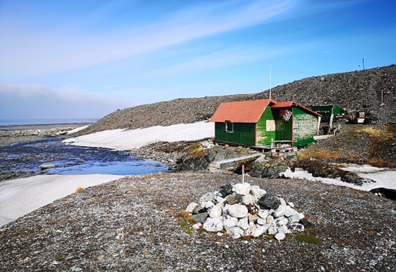
The research station is located on Wedel Jarlsberg Land, on the west coast of Spitsbergen, the largest island in the Svalbard archipelago. The station building is located on the bedrock outcrop, right under the embankment of the lateral moraine of the Werenskiold Glacier. This place is 550 m away from the coast of Nottinghambukta and elevated ca. 15 m above sea level. The Brattegg stream flows next to the building, where in a small river gorge, creates a 2.5-meter high waterfall. The station is located in the Sør-Spitsbergen National Park established in 1973.

Climate data

Grey colours are WMO Climate Normals including maximum and minimum values. Blue colours are individual years.

Climate data for the stations where extracted via Copernicus Climate Data Store, from the global gridded reanalysis product: ERA5 monthly averaged data on single levels from 1940 to present. Description and source code: Roemer J.K. 2023. https://doi.org/10.5281/zenodo.10214922 Data Source: Hersbach et al. 2023. Copernicus Climate Change Service (C3S) Climate Data Store (CDS), https://doi.org/10.24381/cds.f17050d7

Biodiversity and natural environment

Spitsbergen is a major island of one of the northernmost archipelagos in the Arctic - Svalbard. The station is surrounded by glaciers, moraines, rivers, mountains and a typical tundra system. Most of the fauna living in Svalbard is represented in the area with birds (auks, kittiwakes, terns, barnacle geese, etc.), reindeers, foxes, polar bears and often visible in the fjord are seals and sometimes belugas and walrus.

History and facilities

The station was built in 1971 below the site on the lateral moraine of the Werenskiold Glacier, where a meteorological station was established in 1970. The building was assembled from wooden, ready-made elements that were prepared earlier in Wrocław, Poland and transported to Spitsbergen on the ship. The initiator of the construction of the facility was Dr Stanisław Baranowski (glaciologist). Over the years the station overcome multiple renovations and modification and currently provides basic logistical resources: accomodation and storage facilities for research groups working in the area.

General research and databases

Station supports fieldowrk in number of scientific disciplines. The key areas of research are geomorphological (including permafrost studies), glaciological, climatological, geological and ecological studies. Both, long term and short term projects are carried out at the Station.

Station Monitoring

Human dimension

There is no permanent population living in the area and activities are mainly linked to science. The nearest, permanently inhabited place is the Polish Polar Station in Hornsund located 15 km to the south. Visits of tourists coming mostly from yachts for just a few hours are rather rare. The closest town is Longyearbyen (population c. 2000) located ca. 130 km north of the Station.

Access

Access is possible only by ship/yacht or sppedboat to nearby Hyttevika or Nothinghambukta. From the shore ca. 30 minutes walk in a rough terrain is required. There are no regular ship transport to the station and organization of own transport is required. Transport of freight is possible to the Polish Polar station in Hornsund, which later on can be transport near the Station using zodiacs. Fjord shores and islands are easily accessible using zodiacs.

Member of: